USGS - science for a changing world

USGS Open-File Report 2011-1172

Habitat Diversity in the Northeastern Gulf of Mexico: Selected Video Clips from the Gulfstream Natural Gas Pipeline Digital Archive

By Ellen A. Raabe, Robert D'Anjou, Domonique K. Pope, and Lisa L. Robbins


Overview | Study Locations | Seafloor Habitats | Habitat Mosaic | Resources


Study Locations

Northeastern Gulf of Mexico

The Gulf of Mexico is the ninth largest body of water in the world. It consists of a shallow intertidal zone, a slightly inclined continental shelf and slope, and a deep abyssal sea, exceeding 3,000 m in depth. The dynamic ecosystem and unusual structure of the gulf establish it as a major resource for offshore oil drilling, commercial and sport fishing, sand, and other natural resources.

The northeastern Gulf of Mexico seafloor, from Alabama to the central Florida Gulf Coast, is characterized by shallow, soft sediments. Along the Florida Panhandle coast and into Alabama, there are substantial influx and deposition of terrigenous sediment from several rivers. To the east and south, the surface deposits transition to carbonate-dominated sediments over a limestone shelf.

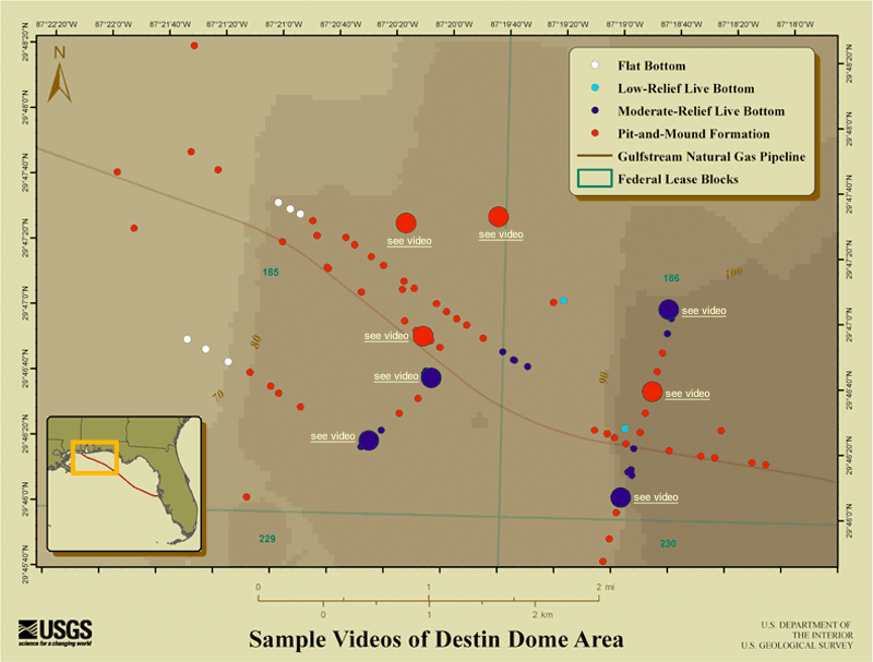
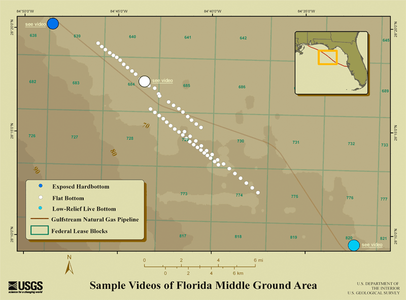
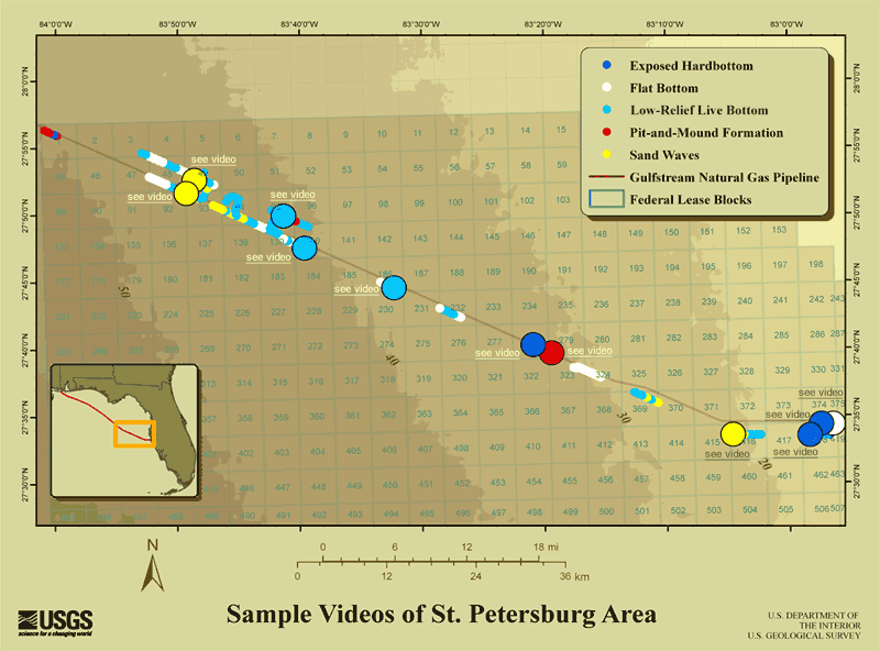
The video survey area encompasses 410 km of seafloor, from water depths of 5 to 100 m. The selected clips are available from three general block areas: Destin Dome, Florida Middle Ground, and St. Petersburg. The geographic location of each video segment is an accurate conversion of the x,y coordinates. However, the lease-block number provided for selected clips reflects the starting point of an entire 120-minute video. There is no video footage below approximately 100 m because the camera-cable length was limited.

Each area block is shown with more detail about the habitats and the movie clips available for each type of habitat. Click on the block area of interest and then select a habitat movie to view.

What is an area block?

An area block is a geographic unit established by Offshore Energy and Minerals Management (OEMM, a branch of the Federal Bureau of Ocean Energy Management) to designate lease activities on the Outer Continental Shelf (OCS). Each area block consists of 700-1,500 Federal lease blocks of 23 square kilometers each. Each Federal lease block may be evaluated and used for commercial extraction of natural resources, such as oil and natural gas.

Map showing the proposed Gulfstream Natural Gas Pipeline.
Click to view a map showing video locations from the Destin Dome Area Block. Click to view a map showing video locations from the Florida Middle Ground Area Block. Click to view a map showing video locations from the St. Petersburg Area Block.
Map showing the proposed Gulfstream Natural Gas Pipeline. The brown line shows the area of underwater video collected by Sea Byte, Inc. (2001). The dotted line shows water depths greater than 100 meters, where underwater videos were not collected.

Maps of Sample Video Locations

Destin Dome Area Block

Destin Dome Area Block Click to see the video for Pit-and-Mound Habitat #2 Click to see the video for Pit-and-Mound Habitat #3 Click to see the video for Pit and Mound #4 Click to see the video for Moderate-Relief Live Bottom #3 Click to see the video for Moderate-Relief Live Bottom #4 Click to see the video for Moderate-Relief Live Bottom #2 Click to see the video for Pit-and-Mound Habitat #1 Click to see the video for Moderate-Relief Live Bottom #1
Destin Dome Area Block. The small circles represent 5-minute video segments of seafloor habitat from which selected video clips were derived. The large circles represent select movie clips for different habitats. Click on a large circle to view the underwater video for that location.

Florida Middle Ground Area Block

Florida Middle Ground Area Block Click to see video for Exposed Hardbottom #2 Click to see video for Flat Bottom #1 Click to see video for Low-Relief Live Bottom #4
Florida Middle Ground Area Block. The small circles represent 5-minute video segments of seafloor habitat from which selected video clips were derived. The large circles represent select movie clips for different habitats. Click on a large circle to view the underwater video for that location.

St. Petersburg Area Block

 St. Petersburg Area Block Click to see video for Sandwave Habitat #2 Click to see video for Sandwave Habitat #1 Click to see video for Low-Relief Live Bottom #1 Click to see video for Low-Relief Live Bottom #2 Click to see video for Low-Relief Live Bottom #3 Click to see video for Exposed Hardbottom #3 Click to see video for Pit-and-Mound Habitat #5 Click to see video for Sandwave Habitat #3 Click to see video for Exposed Hardbottom #1 Click to see video for Exposed Hardbottom #4 Click to see video for Flat Bottom #2
St. Petersburg Area Block. The small circles represent 5-minute video segments of seafloor habitat from which selected video clips were derived. The large circles represent select movie clips for different habitats. Click on a large circle to view the underwater video for that location.

Accessibility FOIA Privacy Policies and Notices

Take Pride in America logo USA.gov logo U.S. Department of the Interior | U.S. Geological Survey
URL: http://pubsdata.usgs.gov/pubs/of/2011/1172/studylocations.html
Page Contact Information: GS Pubs Web Contact
Page Last Modified: Wednesday, 07-Dec-2016 23:50:14 EST