2009-002-FA: <http://woodshole.er.usgs.gov/operations/ia/public_ds_info.php?fa=2009-002-FA>
2010-004-FA: <http://woodshole.er.usgs.gov/operations/ia/public_ds_info.php?fa=2010-004-FA>
2011-004-FA: <http://woodshole.er.usgs.gov/operations/ia/public_ds_info.php?fa=2011-004-FA>
U.S. Geological Survey, 2012, VS_BACKSCATTERTRACKLINES: Survey lines along which acoustic backscatter data were acquired using a Klein 3000 sidescan sonar offshore of Massachusetts within Vineyard Sound by the U.S. Geological Survey in 2009, 2010, and 2011 (ESRI Shapefile, Geographic WGS84).: Open-File Report 2012-1006, U.S. Geological Survey, Coastal and Marine Geology Program, Woods Hole Coastal and Marine Science Center, Woods Hole, Massachusetts.This is part of the following larger work.Online Links:
- <http://pubs.usgs.gov/of/2012/1006/GIS/raster/backscatter/vs_backscatter_1m.zip>
- <http://pubs.usgs.gov/of/2012/1006/appendix.html>
Andrews, Brian D. , Ackerman, Seth D. , Baldwin, Wayne E. , Foster, David S. , and Schwab, William C. , 2012, High-Resolution Geophysical Data From the Inner Continental Shelf at Vineyard Sound, Massachusetts: Open-File Report 2012-1006, U.S. Geological Survey, Coastal and Marine Geology Program, Woods Hole Coastal and Marine Science Center, Woods Hole, Massachusetts.Online Links:
This is a Vector data set. It contains the following vector data types (SDTS terminology):
Horizontal positions are specified in geographic coordinates, that is, latitude and longitude. Latitudes are given to the nearest 0.000001. Longitudes are given to the nearest 0.000001. Latitude and longitude values are specified in Decimal degrees.
The horizontal datum used is D_WGS_1984.
The ellipsoid used is WGS_1984.
The semi-major axis of the ellipsoid used is 6378137.000000.
The flattening of the ellipsoid used is 1/298.257224.
Sequential unique whole numbers that are automatically generated.
Coordinates defining the features.
Character set.
Character set.
Character set.
Character set.
| Range of values | |
|---|---|
| Minimum: | 0.02367 |
| Maximum: | 20.5541 |
| Units: | kilometer |
508-548-8700 x2348 (voice)
508-457-2310 (FAX)
bandrews@usgs.gov
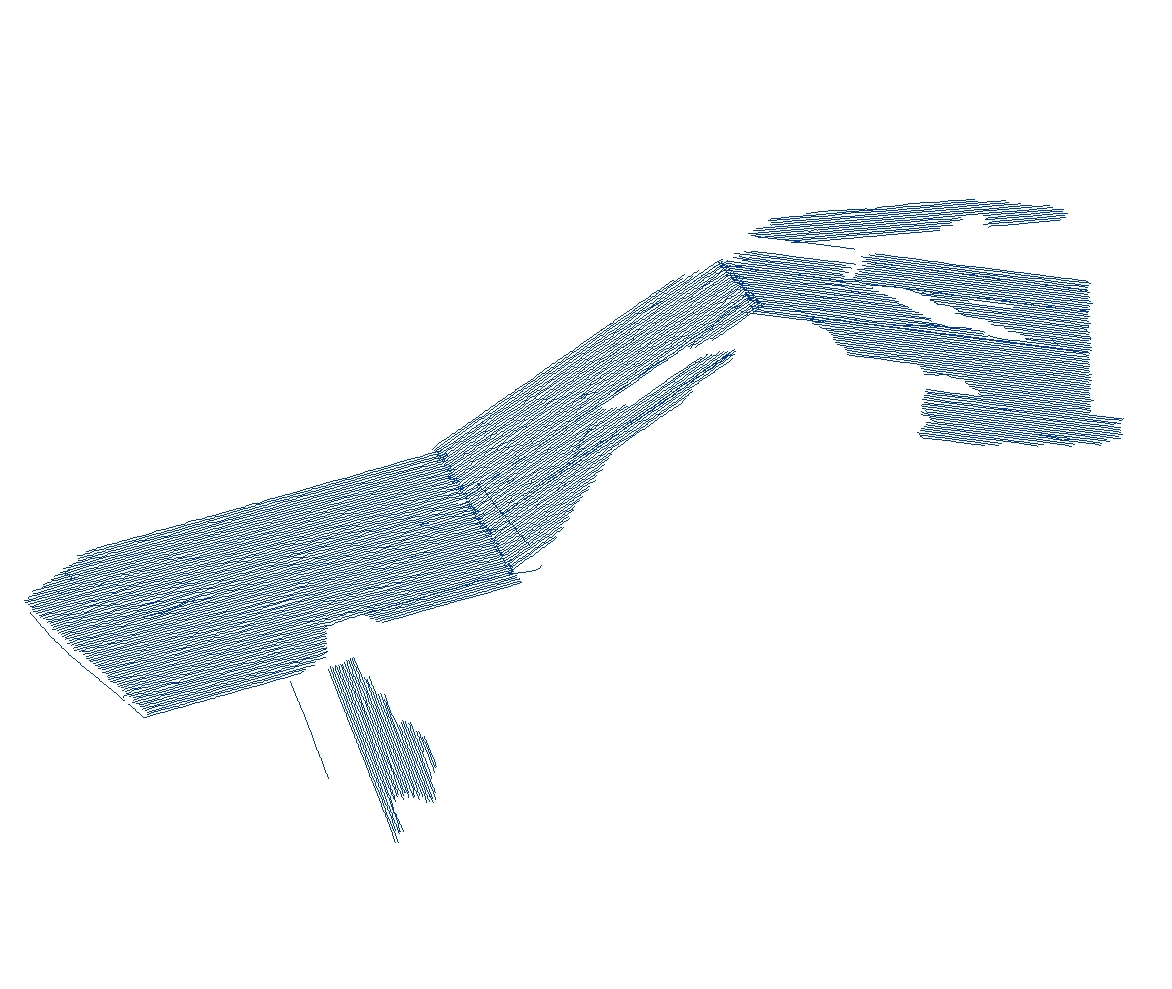
The purpose of these data is to provide the trackline navigation and filenames of all the acoustic backscatter data acquired using a Klein 3000 sidescan-sonar within the Vineyard Sound survey area during these surveys.
Person who carried out this activity:
508-548-8700 x2348 (voice)
508-457-2310 (FAX)
bandrews@usgs.gov
Person who carried out this activity:
508-548-8700 x2348 (voice)
508-457-2310 (FAX)
bandrews@usgs.gov
Person who carried out this activity:
508-548-8700 x2348 (voice)
508-457-2310 (FAX)
bandrews@usgs.gov
Person who carried out this activity:
508-548-8700 x2348 (voice)
508-457-2310 (FAX)
bandrews@usgs.gov
Danforth, William W. , 1997, XSonar/ShowImage: A complete system for rapid sidescan-sonar processing and display.: Open-File Report 97-686, U.S. Geological Survey, Woods Hole Science Center, Woods Hole, MA.
All attributes were checked in a consistent manner.
Field activity 2009-002-FA: The Klein 3000 was towed from the stern A-frame of the M/V Megan T. Miller. Differential GPS (DGPS) position data were provided by the Ashtech BRG2 receiver and recorded to the raw data files (XTF) via SonarPro (version 10.0) on the sonar acquisition computer. The GPS antenna was mounted on the aft end of the acquisition lab van. All GPS data during this survey was referenced to the WGS84 horizontal datum. The horizontal offsets between the GPS antenna and the sheave on the A-frame were measured prior to the survey (x: -2.0m; y:-8.35m; z:+2m). Additional layback position, accounting for the linear distance between the sheave on the A-frame and the towed sonar system were measured by a 3PS digital block cable counter on the winch that was used to deploy the sidescan-sonar towfish. All of the horizontal offsets were directly applied into the acquisition software so the navigation recorded in the XTF data reflect the position including the layback offset. The layback calculations do not account for fish motion behind the vessel, which is caused by sea state and vessel speed-induced changes in the angle and scope of the tow cable. DGPS positional accuracy is estimated to be within 3-5 m; Wide Area Augmentation System enable DGPS is estimated to be within less than 3 m. Considering the additional fish motion and cable movement, a conservative estimate of positional accuracy for this dataset is estimated to be within 10 m.
Field activity 2010-004-FA: The Klein 3000 was towed from the stern A-frame of the M/V Megan T. Miller. Real-Time Kinematic (RTK) GPS position data were provided by the Novatel DL-V3 receiver and recorded to the raw data files (XTF) via SonarPro (version 11.0) on the sonar acquisition computer. The GPS antenna was mounted on the top of the SWATHplus (interferometric bathymetry) transducer pole, midship on the starboard side (the middle of the 3 bathymetry system antennas). On a few brief occasions the RTK-GPS signal was lost and the navigation system fell back to standalone DGPS or GPS mode. In these cases, the lower quality positions were used and no corrections were made for RTK navigation gaps. All GPS data during this survey were referenced to the WGS84 horizontal datum. The horizontal offsets between the GPS antenna and the sheave on the A-frame were measured prior to the survey (x:-4.1m; y:-14.94m; z:-1.33m). Additional layback position, accounting for the linear distance between the sheave on the A-frame and the towed sonar system were measured by a 3PS digital block cable counter on the winch that was used to deploy the sidescan-sonar towfish. All of the horizontal offsets were directly applied into the acquisition software so the navigation recorded in the XTF data reflect the position including the layback offset. The layback calculations do not account for fish motion behind the vessel, which is caused by sea state and vessel speed induced changes in the angle and scope of the tow cable. RTK positional accuracy is estimated to be within less than 1 m. Taking the additional fish motion, cable movement and RTK-GPS navigation dropouts into account, a conservative estimate of positional accuracy for this dataset is estimated to be within 10 m.
Field activity 2011-004-FA: The Klein 3000 was towed from the stern A-frame of the M/V Scarlett Isabella. Differential GPS (DGPS) position data were provided by the Ashtech BRG2 receiver and recorded to the raw data files (XTF) via SonarPro (version 11.0) on the sonar acquisition computer. The GPS antenna was mounted on the forward end of the acquisition lab van. All GPS data during this survey was referenced to the WGS84 horizontal datum. The horizontal offsets between the GPS antenna and the sheave on the A-frame were measured prior to the survey (x: +4.31m; y:-9.18m; z:0.0m). Additional layback position, accounting for the linear distance between the sheave on the A-frame and the towed sonar system were measured by a 3PS digital block cable counter on the winch that was used to deploy the sidescan-sonar towfish. All of the horizontal offsets were directly applied into the acquisition software so the navigation recorded in the XTF data reflect the position including the layback offset. The layback calculations do not account for fish motion behind the vessel, which is caused by sea state and vessel speed induced changes in the angle and scope of the tow cable. DGPS positional accuracy is estimated to be within 3-5 m; WAAS enable DGPS is estimated to be within less than 3 m. Taking the additional fish motion and cable movement into account, a conservative estimate of positional accuracy for this dataset is estimated to be within 10 m.
Only the subset of sidescan-sonar trackline navigation collected during field activities 2009-002-FA, 2010-004-FA, and 2011-004-FA that are within the Vineyard Sound survey area are included in this spatial dataset.
Navigation data were extracted from the header of the raw line files. They have been compared to other navigation data collected during the cruise for consistency. Any spurious data points were removed during processing.
Are there legal restrictions on access or use of the data?
- Access_Constraints: None
- Use_Constraints:
- These data are not for navigational use. Public domain data from the U.S. Government are freely redistributable with proper metadata and source attribution. Please recognize the U.S. Geological Survey (USGS) as the source of this information.
508-548-8700 x2348 (voice)
bandrews@usgs.gov
Downloadable Data
Neither the U.S. Government, the Department of the Interior, nor the USGS, nor any of their employees, contractors, or subcontractors, make any warranty, express or implied, nor assume any legal liability or responsibility for the accuracy, completeness, or usefulness of any information, apparatus, product, or process disclosed, nor represent that its use would not infringe on privately owned rights. The act of distribution shall not constitute any such warranty, and no responsibility is assumed by the USGS in the use of these data or related materials. Any use of trade, product, or firm names is for descriptive purposes only and does not imply endorsement by the U.S. Government.
| Data format: | Trackline navigation for acoustic backscatter collected within the Vineyard Sound survey area and associated metadata. in format SHP (version ArcGIS 9.3) ESRI polyline shapefile Size: 0.721 |
|---|---|
| Network links: |
<http://pubs.usgs.gov/of/2012/1006/GIS/shapefile/VS_BackscatterTracklines.zip> |
| Media you can order: |
DVD-ROM
(Density 4.75
Gbytes)
(format UDF)
|
This zip file contains data available in Environmental Systems Research Institute (ESRI) shapefile format. The user must have software capable of uncompressing the WinZip file and displaying the shapefile. In lieu of ArcView or ArcGIS, the user may utilize another GIS application package capable of importing the data. A free data viewer, ArcExplorer, capable of displaying the data is available from ESRI at www.esri.com.
508-548-8700 x2348 (voice)
508-457-2310 (FAX)
bandrews@usgs.gov