 Summary Summary
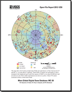
The Mars Global Digital Dune Database (MGD3) provides data and describes the methodology used in creating the global database of moderate- to large-size dune fields on Mars. The database is being released in a series of U.S. Geological Survey Open-File Reports. The first report (Hayward and others, 2007) included dune fields from lat 65° N. to 65° S. (http://pubs.usgs.gov/of/2007/1158/). The second report (Hayward and others, 2010) included dune fields from lat 60° N. to 90° N. (http://pubs.usgs.gov/of/2010/1170/). This report encompasses ~75,000 km2 of mapped dune fields from lat 60° to 90° S. The dune fields included in this global database were initially located using Mars Odyssey Thermal Emission Imaging System (THEMIS) Infrared (IR) images. In the previous two reports, some dune fields may have been unintentionally excluded for two reasons: (1) incomplete THEMIS IR (daytime) coverage may have caused us to exclude some moderate- to large-size dune fields or (2) resolution of THEMIS IR coverage (100 m/pixel) certainly caused us to exclude smaller dune fields. In this report, mapping is more complete. The Arizona State University THEMIS daytime IR mosaic provided complete IR coverage, and it is unlikely that we missed any large dune fields in the South Pole (SP) region. In addition, the increased availability of higher resolution images resulted in the inclusion of more small (~1 km2) sand dune fields and sand patches. To maintain consistency with the previous releases, we have identified the sand features that would not have been included in earlier releases. While the moderate to large dune fields in MGD3 are likely to constitute the largest compilation of sediment on the planet, we acknowledge that our database excludes numerous small dune fields and some moderate to large dune fields as well. Please note that the absence of mapped dune fields does not mean that dune fields do not exist and is not intended to imply a lack of saltating sand in other areas.
Where availability and quality of THEMIS visible (VIS), Mars Orbiter Camera (MOC) narrow angle, Mars Express High Resolution Stereo Camera, or Mars Reconnaissance Orbiter Context Camera and High Resolution Imaging Science Experiment images allowed, we classified dunes and included some dune slipface measurements, which were derived from gross dune morphology and represent the approximate prevailing wind direction at the last time of significant dune modification. It was beyond the scope of this report to look at the detail needed to discern subtle dune modification. It was also beyond the scope of this report to measure all slipfaces. We attempted to include enough slipface measurements to represent the general circulation (as implied by gross dune morphology) and to give a sense of the complex nature of aeolian activity on Mars. The absence of slipface measurements in a given direction should not be taken as evidence that winds in that direction did not occur. When a dune field was located within a crater, the azimuth from crater centroid to dune field centroid was calculated, as another possible indicator of wind direction. Output from a general circulation model is also included. In addition to polygons locating dune fields, the database includes ~700 of the THEMIS VIS and MOC images that were used to build the database.
|
First posted December 31, 2012
-
This report is available only on the Web.
Part of this report is presented in Portable Document Format (PDF); the latest version of Adobe Reader or similar software is required to view it. Download the latest version of Adobe Reader, free of charge. |

