Open-File Report 2012-1266
|
First posted December 3, 2013 Report
For additional information, contact: Part or all of this report is presented in Portable Document Format (PDF). For best results viewing and printing PDF documents, it is recommended that you download the documents to your computer and open them with Adobe Reader. PDF documents opened from your browser may not display or print as intended. Download the latest version of Adobe Reader, free of charge. |
Andrews, B.D., Chaytor, J.D., ten Brink, U.S., Brothers, D.S., Gardner, J.V., Lobecker, E.A., and Calder, B.R., 2016, Bathymetric terrain model of the Atlantic margin for marine geological investigations (ver. 2.0, May 2016): U.S. Geological Survey Open-File Report 2012–1266, 19 p., 1 pl., http://dx.doi.org/10.3133/ofr20121266.
ISSN 2331-1258 (online)
Abstract
Introduction
Setting
Methods
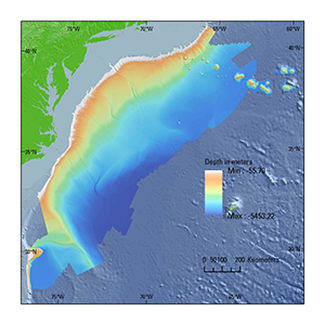
Bathymetry
Sediment Distribution
Bottom Photography
GIS Data Catalog
Summary
Acknowledgments
References

![]() U.S. Department of the Interior |
U.S. Geological Survey
U.S. Department of the Interior |
U.S. Geological Survey
URL: http://pubsdata.usgs.gov/pubs/of/2012/1266/index.html
Page Contact Information: GS Pubs Web Contact
Page Last Modified: Wednesday, 25-May-2016 13:27:54 EDT