U.S. Geological Survey Open-File Report 2013–1060
Sea-floor geology and topography offshore in northeastern Long Island Sound
 |
||
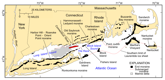
Figure 2. Map showing the location of end moraines, submerged moraine lines in southern New York and New England (modified from Gustavson and Boothroyd, 1987), the extent of marine deltaic deposits from the Connecticut River (Lewis and DiGiacomo-Cohen, 2000), and the location of the study area (red polygon). The Ronkonkoma-Block Island-Nantucket end moraine represents the maximum advance of the Laurentide Ice Sheet about 20,000-24,000 years ago; the Harbor Hill-Roanoke Point-Charleston-Buzzards Bay end moraine represents a retreated ice-sheet position from about 18,000-21,000 years ago (Uchupi and others, 1996; Balco and others, 2002, Balco and others, 2009). |
||

![]() U.S. Department of the Interior |
U.S. Geological Survey
U.S. Department of the Interior |
U.S. Geological Survey
URL: http://pubsdata.usgs.gov/pubs/of/2013/1060/html/fig2.html
Page Contact Information: GS Pubs Web Contact
Page Last Modified: Friday, 27-Sep-2013 08:53:50 EDT


