U.S. Geological Survey Open-File Report 2013–1060
Sea-Floor Geology and Topography Offshore in Northeastern Long Island Sound
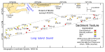
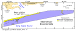
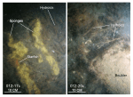
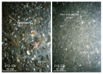
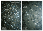
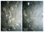
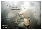
Sediments and Sedimentary EnvironmentsThe funnel-shaped geometry of eastern Long Island Sound constricts tidal flow, which produces strong bottom currents (Signell and others, 2000), coarse-grained sediments (Poppe and others, 2000), and high-energy sedimentary environments (Knebel and Poppe, 2000). Surface-sediment texture in the study area ranges from boulders to silt (fig. 23); sedimentary environments range from those characterized by processes associated with erosion and nondeposition to those characterized by coarse bedload transport (fig. 24). Erosion and NondepositionBoulders, which are present as lag deposits on bedrock outcrops and the winnowed surfaces of Pleistocene glacial drift, reflect high-energy sedimentary environments and are concentrated in the eastern part of the study area south of Black Point and at scattered locations along the study area's southern edge. Individual boulders are typically covered by sessile fauna (fig. 25), suggesting that they are immobile even during severe storms. The sessile fauna, which commonly includes sponges, hydroids, bushy hydrozoans, mussels, and anemones, is ecologically important because it adds to the overall benthic roughness and diversity that in turn promotes benthic biologic complexity (Zajac and others, 2000). Gravel and gravelly sediment surround the rocky eastern areas and dominate the surface sediment in a broad swath across the central and southern parts of the study area, serving to armor the sea floor and limit further erosion (figs. 23 and 26). The sea floor in these areas is relatively flat, and longitudinal ripples, an erosional bedform, and scour features around obstructions are common, suggesting that these areas are sediment starved. Sessile biota, such as bushy hydrozoans, cover the larger gravel, but smaller gravel is clean, suggesting episodic transport of the finer fraction. Although sediment discharged from the Connecticut River regularly impacts the study area, strong tidal currents apparently prevent deposition of this finer grained detritus. Mussel beds were observed at scattered locations in the gravelly areas (fig. 27). Accumulations of shells and shell debris associated with the mussel beds are thin, patchy, and probably ephemeral, but these shell beds are still ecologically important because they form sea-floor habitats of rough, relatively hard substrates that add to the overall benthic compositional complexity. Bottom photography, here and elsewhere in the sound (Poppe and others, 2011c), shows that infauna construct burrows in the shell deposits, juvenile finfish shelter between the shells, and sessile fauna and flora attach themselves to the hard substrate provided by the shells. Coarse Bedload TransportPoorly to moderately sorted sand dominates the surface sediments in the northwestern part of the study area and at scattered locations in deeper water (fig. 23). The sands in the northwestern corner of the study area are associated with reworked remnants of the large marine delta built by sediments from the draining of glacial Lake Hitchcock; the sands in the deeper water are associated with small, isolated fields of sand waves. These areas are characterized by well-developed current ripples and sedimentary environments characterized by processes associated with coarse-bedload transport (fig. 24). Shell hash concentrates in the ripple troughs, but where scattered larger shells and gravel are present, scour depressions have formed around the larger clasts (fig. 28). Gray to reddish-gray cohesive mud is present at station 012-11 from near the base of the eroded marine delta, where it occurs as both irregular, eroded clasts and as outcrops (figs. 28 and 29). We would argue that this lithology is that of the original unwinnowed deltaic deposits, and that its cohesiveness limits erosion, helping to maintain the steep southern slope of the marine delta. Although unsampled during this study, silt was reported in a core taken just east of station 012-11 (Williams, 1981; Poppe and others, 1998a) and exposed, cohesive gray sand-silt-clay interpreted to be part of the delta was reported in a study to the southwest (McMullen and others, 2012). Sediment DataThe sediment-grain-size dataset provided in the Data Catalog section of this report contains information on the collection, location, description, and texture of sediments at 21 stations occupied during the R/V Rafael 2010-010-FA and OSV Bold 2010-015-FA verification cruises (fig. 23). All analyses were conducted in the Sedimentation Laboratory at the USGS Woods Hole Coastal and Marine Science Center in Woods Hole, Mass. Records without textural data and statistics are based on visual descriptions. The basic structure of the data is a flat-file format, a matrix where records are rows representing individual samples and the columns contain sample- and station-specific information. This matrix consists of 42 fields, which are defined in the Data Dictionary below. The sediment data are provided in three formats: Esri shapefile, Microsoft Excel, and delimited ASCII text. In the delimited ASCII text file, each field or column of data is separated from the next by commas and can be downloaded into many types of software. These files are available through the Data Catalog section of this report. Data DictionaryAn integral part of any database is the dictionary that explains its structure and content. The dictionary contains a list of the fields and the definitions of parameters measured. Data utilization is facilitated by reference to this compilation because it defines abbreviations and lists field names. LABNO - Unique sample identifier assigned in the laboratory STATIONID - Sample name or number assigned in the field PROJECT - Project under which samples were collected or data generated CRUISEID - Name or number of cruise on which sample was collected or station occupied PRINCIPAL - Name of principal investigator LATITUDE - Latitude in decimal degrees LONGITUDE - Longitude in decimal degrees (west longitudes are negative values) DEPTH_M - Depth of water measured by a hull-mounted fathometer overlying sediment at the time of sampling, not corrected for tides, in meters T_DEPTH - Top depth of the sample below the sediment-water interface, in centimeters B_DEPTH - Bottom depth of the sample below the sediment-water interface, in centimeters DEVICE - Device used to collect the sample MONTH - Number of calendar month during which the sample was collected DAY - Calendar day on which the sample was collected YEAR - Calendar year during which the sample was collected WEIGHT – Dry weight of sample, in grams ZGRAVEL - Gravel (particles with nominal diameters greater than 2 millimeters (-1 phi and larger)) content of the sample, in percent dry weight ZSAND - Sand (particles with nominal diameters less than 2 millimeters but greater than or equal to 0.0625 millimeter (0 through 4 phi)) content of the sample, in percent dry weight ZSILT - Silt (particles with nominal diameters less than 0.0625 millimeter but greater than or equal to 0.004 millimeter (5 through 8 phi)) content of the sample, in percent dry weight ZCLAY - Clay (particles with nominal diameters less than 0.004 millimeter (9 phi and smaller)) content of the sample, in percent dry weight SEDCLASS - Sediment description based on a rigorous definition (Shepard, 1954; Schlee, 1973; Poppe and others, 2004b) where, for sediments with gravel equal to or greater than 10 percent: GRAVEL – gravel equal to or greater than 50 percent GRAVELLY SEDIMENT – gravel equal to or greater than 10 percent, but less than 50 percent and where, for sediments with gravel less than 10 percent: SAND – sand equal to or greater than 75 percent SILTY SAND - sand less than 75 percent and equal to or greater than 50 percent, silt greater than clay, and clay less than 20 percent CLAYEY SAND - sand less than 75 percent and equal to or greater than 50 percent, clay greater than silt, and silt less than 20 percent SILT - silt equal to or greater than 75 percent SANDY SILT – silt less than 75 percent and equal to or greater than 50 percent, sand greater than clay, and clay less than 20 percent CLAYEY SILT - silt less than 75 percent and equal to or greater than 50 percent, clay greater than sand, and sand less than 20 percent CLAY – clay equal to or greater than 75 percent SANDY CLAY - clay less than 75 percent and equal to or greater than 50 percent, sand greater than silt, and silt less than 20 percent SILTY CLAY - clay less than 75 percent and equal to or greater than 50 percent, silt greater than sand, and sand less than 20 percent SAND SILT CLAY – clay, sand, and silt greater than 20 percent each MEDIAN - Middle point in the grain-size distribution, in phi units MEAN - Average value in the grain-size distribution, in phi units STDDEV - Standard deviation (root mean square of the deviations) of the grain-size distribution (that is, sorting), in phi units SKEWNESS - Deviation from symmetrical form of the grain-size distribution KURTOSIS - Degree of curvature near the mode of the grain-size distribution PHI _11 - Weight percent of the sample in the 11-phi fraction (nominal diameter of particles greater than or equal to 0.0005 millimeter but less than 0.001 millimeter); fine clay PHI_10 - Weight percent of the sample in the 10-phi fraction (nominal diameter of particles greater than or equal to 0.001 millimeter but less than 0.002 millimeter); medium clay PHI_9 - Weight percent of the sample in the 9-phi fraction (nominal diameter of particles greater than or equal to 0.002 millimeter but less than 0.004 millimeter); coarse clay PHI_8 - Weight percent of the sample in the 8-phi fraction (nominal diameter of particles greater than or equal to 0.004 millimeter but less than 0.008 millimeter); very fine silt PHI_7 - Weight percent of the sample in the 7-phi fraction (nominal diameter of particles greater than or equal to 0.008 millimeter but less than 0.016 millimeter); fine silt PHI_6 - Weight percent of the sample in the 6-phi fraction (nominal diameter of particles greater than or equal to 0.016 millimeter but less than 0.031 millimeter); medium silt PHI_5 - Weight percent of the sample in the 5-phi fraction (nominal diameter of particles greater than or equal to 0.031 millimeter but less than 0.0625 millimeter); coarse silt PHI_4 - Weight percent of the sample in the 4-phi fraction (nominal diameters of particles greater than or equal to .0625 millimeter but less than 0.125 millimeter); very fine sand PHI_3 - Weight percent of the sample in the 3-phi fraction (nominal diameter of particles greater than or equal to 0.125 millimeter but less than 0.25 millimeter); fine sand PHI_2 - Weight percent of the sample in the 2-phi fraction (nominal diameter of particles greater than or equal to 0.25 millimeter but less than 0.5 millimeter); medium sand PHI_1 - Weight percent of the sample in the 1-phi fraction (nominal diameter of particles greater than or equal to 0.5 millimeter but less than 1 millimeter); coarse sand PHI_0 - Weight percent of the sample in the 0-phi fraction (nominal diameters of particles greater than or equal to 1 millimeter but less than 2 millimeters); very coarse sand PHIM1 - Weight percent of the sample in the -1-phi fraction (nominal diameter of particles greater than or equal to 2 millimeters but less than 4 millimeters); very fine pebbles (granules) PHIM2 - Weight percent of the sample in the -2-phi fraction (nominal diameter of particles greater than or equal to 4 millimeters but less than 8 millimeters); fine pebbles PHIM3 - Weight percent of the sample in the -3-phi fraction (nominal diameter of particles greater than or equal to 8 millimeters but less than 16 millimeters); medium pebbles PHIM4 - Weight percent of the sample in the -4-phi fraction (nominal diameter of particles greater than or equal to 16 millimeters but less than 32 millimeters); coarse pebbles PHIM5 - Weight percent of the sample in the -5-phi fraction (nominal diameter of particles greater than or equal to 32 millimeters); very coarse pebbles to boulders |

![]() U.S. Department of the Interior |
U.S. Geological Survey
U.S. Department of the Interior |
U.S. Geological Survey
URL: http://pubsdata.usgs.gov/pubs/of/2013/1060/html/seds.html
Page Contact Information: GS Pubs Web Contact
Page Last Modified: Friday, 27-Sep-2013 09:25:42 EDT