U.S. Geological Survey Open-File Report 2013–1060
Sea-floor geology and topography offshore in northeastern Long Island Sound
 |
||
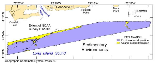
Figure 24. Distribution of sedimentary environments based on the digital terrain model from National Oceanic and Atmospheric Administration (NOAA) survey H12012 and verification data from U.S. Geological Survey cruises 2010-010-FA and 2010-015-FA. Areas characterized by erosion or nondeposition, and coarse bedload transport are shown. |
||

![]() U.S. Department of the Interior |
U.S. Geological Survey
U.S. Department of the Interior |
U.S. Geological Survey
URL: http://pubsdata.usgs.gov/pubs/of/2013/1060/html/fig24.html
Page Contact Information: GS Pubs Web Contact
Page Last Modified: Friday, 27-Sep-2013 10:06:23 EDT


