Open-File Report 2014–1234
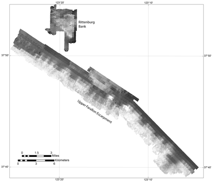
Data CatalogThis report contains bathymetry and acoustic-backscatter data collected along the outer mainland shelf and upper slope of the Farallon Escarpment as well as Rittenburg Bank. The report also contains interpreted seafloor character maps of the same region. These bathymetry and acoustic backscatter data were collected in 2011 by the U.S. Geological Survey in cooperation with the National Oceanic and Atmospheric Administration (NOAA) using a 100-kHz Reson 7111 multibeam echsounder (USGS FACS-ID F-01-11-NC). See report summary for mapping and data processing details. The tables below provide the bathymetry, acoustic-backscatter imagery, and interpreted seafloor character maps. To view an overview map, click on the "Quick View" links. Bathymetry data are available in ASCIIRaster format files and shaded-relief bathymetry geoTIFF images. Acoustic-backscatter images are available as geoTIFF images. The interpreted seafloor character maps are available as geoTIFF images. The bathymetry data are horizonatally projected to UTM, zone 10, North America Datum of 1983 (CORS96) coordinates, vertically referenced to the North American Vertical Datum of 1988 (NAVD88). The shaded-relief, acoustic backscatter, and seafloor character geoTIFF images are horizonatally projected to UTM, zone 10, North America Datum of 1983 (CORS96) coordinates. NOTE THAT THE USGS COLLECTS BATHYMETRIC DATA FOR SCIENTIFIC PURPOSES ONLY. THE USGS DOES NOT GUARANTEE THAT FULL BOTTOM SEARCH HAS BEEN ACHIEVED AND THE DATA HAVE NOT BEEN INSPECTED FOR DANGERS TO NAVIGATION. THESE DATA ARE NOT INTENDED FOR NAVIGATION. Bathymetry data available to download
Backscatter data available to download
Seafloor Character maps available to download
|
First posted November 24, 2014 For additional information, contact: Part or all of this report is presented in Portable Document Format (PDF). For best results viewing and printing PDF documents, it is recommended that you download the documents to your computer and open them with Adobe Reader. PDF documents opened from your browser may not display or print as intended. Download the latest version of Adobe Reader, free of charge. More information about viewing, downloading, and printing report files can be found here. |

![]() U.S. Department of the Interior |
U.S. Geological Survey
U.S. Department of the Interior |
U.S. Geological Survey
URL: http://pubsdata.usgs.gov/pubs/of/2014/1234/datacatalog.html
Page Contact Information: GS Pubs Web Contact
Page Last Modified: Wednesday, 07-Dec-2016 19:41:07 EST
