2019 Fiscal Year State of the Survey
How the U.S. Geological Survey Accomplishments in FY 2019 Align with Department of the Interior (DOI) Strategic Plan goals
Prepared by the Office of Budget, Planning, and Integration
The following mission area summaries are a high-level overview of the programs housed within each mission area and their annual budgets. These summaries further highlight fiscal year 2019 accomplishments related to the commitments each of the mission areas made to the U.S. Geological Survey priorities the prior year.
Ecosystems
Land Resources
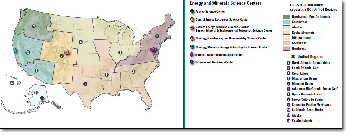
Energy and Minerals
Environmental Health
Natural Hazards
Water Resources
Core Science Systems
Science Support
Special Topic: Quality Management System
Facilities
USGS Regional Realignment
With great satisfaction, I present to you the first U.S. Geological Survey “State of the Survey.” This report focuses on USGS accomplishments from Fiscal Year 2019 that support the 2018–2022 Department of the Interior (DOI) Strategic Plan goals.
The State of the Survey captures notable accomplishments across our organization, demonstrating integrated science, as well as coordinated administrative support, for our enterprise. This report focuses on significant accomplishments that align with DOI Strategic Plan goals. It is not possible to include every accomplishment across the Survey; however, there will be accomplishments from your organization you won’t see. Please be assured the contributions of all of our employees are important and contribute to our success—from technicians collecting samples to acquisition and construction professionals updating our facilities to scientists pioneering the latest advances.
In addition, the State of the Survey provides a snapshot of funds used to finance our mission. It also provides a snapshot of the people who make our mission possible. The goal of including this is to help the reader better appreciate how we pay for what we do and the people who get the job done. I am excited to share this report with you and look forward to advancing our EarthMap concept in the coming year.
Jim

The purpose of the annual State of the Survey report is to provide a consolidated document that looks back at the U.S. Geological Survey’s (USGS’s) organizational performance, budget and finances, and workforce for this past fiscal year. It highlights significant accomplishments from fiscal year (FY) 2019 that support U.S. Department of the Interior (DOI) Strategic Plan goals.
The USGS is a world leader in the natural sciences through our scientific excellence and responsiveness to society’s needs.
The USGS was established in 1879 (43 U.S.C. 31) for “the classification of the public lands and examination of the geological structure, mineral resources, and products of the national domain.” In 1962, Congress expanded the USGS Organic Act to include examinations outside the national domain.
Today, the USGS provides science to inform stewardship of energy and mineral resources; to sustain healthy species populations; to monitor changes to land resources; to improve resilience to natural hazards and enhance community safety and well-being; to improve water resource decision making; and to provide accurate, high-resolution geospatial data. Scientific coordination and collaboration within DOI and across the government is central to the USGS mission. The diversity of USGS scientific expertise enables the Bureau to carry out large-scale, multi-disciplinary investigations and provide scientific information to resource managers and planners, emergency response officials, and the public.
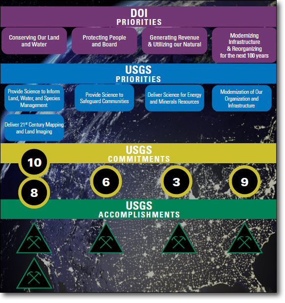
Many DOI priorities are addressed through the work of the USGS. The USGS supports four of the six DOI Strategic Plan1 goals—
The USGS addresses these goals by—
This report highlights selected significant accomplishments in FY 2019 that align with these USGS priorities and support the relevant DOI Strategic Plan goals.
1U.S. Department of the Interior Strategic Plan for Fiscal Years 2018-2022, www.doi.gov/sites/doi.gov/files/uploads/fy2018-2022-strategic-plan.pdf

The USGS Ecosystems Mission Area, the biological research arm of the DOI, provides science to help America achieve sustainable management and conservation of its biological resources. This work is done within the broader mission of the USGS to serve the Nation with science that advances understanding of our natural resources and inform land and water stewardship.
The Ecosystems Mission Area provided science to inform land, water, and species management. Notable accomplishments in FY 2019 in support of the DOI Strategic Plan goals include the following:
The USGS completed the development of the Conservation and Restoration Strategy Tool (CnR tool). This tool supports management decisions in the sagebrush biome and was developed in collaboration with the Bureau of Reclamation, U.S. Fish and Wildlife Service (FWS), the U.S. Department of Agriculture Forest Service, and Western Association of Fish and Wildlife Agencies. The CnR tool was created as a result of the Integrated Rangeland Fire Management Strategy, which sets forth a priority to “suppress rangeland fire and restore sagebrush landscapes impacted by fires across the west.”
The USGS made further improvements to the National Aquatic Species information system (NAS, https://nas.er.usgs.gov/) to improve the ability of managers to conduct biosurveillance for aquatic invasive species. After each observation of a new aquatic nonindigenous species or the observed range expansion of an established nonindigenous species, the NAS alert system sends notification of the observation to interested registered users. In 2018, USGS developed a simplified Alert Risk Mapper (ARM) for the southeastern United States. The ARM provides a mapped visualization of the observation and indicates other waterbodies at risk of invasion given the new observation. In 2019, USGS expanded the scale of the simplified ARM of the NAS to the national scale.
Working with FWS, the USGS established an operational Endangered Species Act (ESA) prelisting species science team to conduct multi-species status assessments. These assessments will increase FWS’s technical capacity and improve efficiency of 7-year work plan species reviews, leading to more expedient decisions. The benefit of this workplan is increased scientific certainty and timeliness of prelisting science decisions, more directed recovery strategies to address key stressors, and reduced public impact for species that do not require listing due to improved scientific understanding.
The USGS developed and made available online data visualization tools for the Wildlife Health Information Sharing Partnership Event Reporting System (WHISPers, https://whispers.usgs.gov/), including interactive maps and summary analytics. WHISPers is a wildlife disease event reporting system where users can explore wildlife mortality data submitted by partners across North America and verified by trained biologists interested in the location of wildlife disease outbreaks.
The USGS published a major review of the impacts of wind energy siting and operations on wildlife. The publication reviews the positive impacts of wind energy for society, as well as the negative and uncertain ecological impacts that affect wildlife. It proposes research needed to minimize negative impacts of land-based and offshore wind energy development and operations.
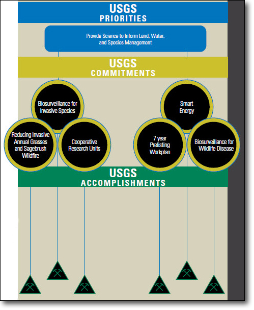
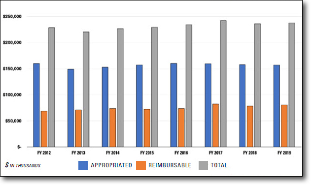
The FY 2019 Ecosystems budget supported six programs: Status and Trends, Fisheries, Wildlife, Environments, Invasive Species, and Cooperative Research Units.
The Land Resources Mission Area uses scientific expertise to help understand a changing world and how it affects our natural resources, livelihoods, and communities. Science plays an essential role in helping communities and resource managers understand the local to global implications of change, anticipate the effects of change, prepare for change, and reduce the risks associated with decision making in a changing environment.
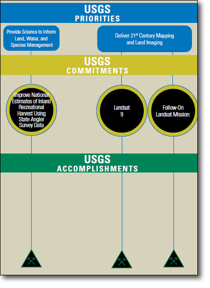
The Land Resources Mission Area provided science to inform land, water, and species management and delivered 21st century mapping and land imaging. Notable accomplishments in FY 2019 in support of the DOI Strategic Plan goals include the following:
The USGS aims to improve national estimates of inland recreational harvest to ensure that the important economic, social, and cultural services provided by inland angling are not discounted. In FY 2019, the USGS has completed compiling data from all 50 States and Puerto Rico on recreational fishing harvest to begin work on a standardized database to model recreational harvest at a national level.
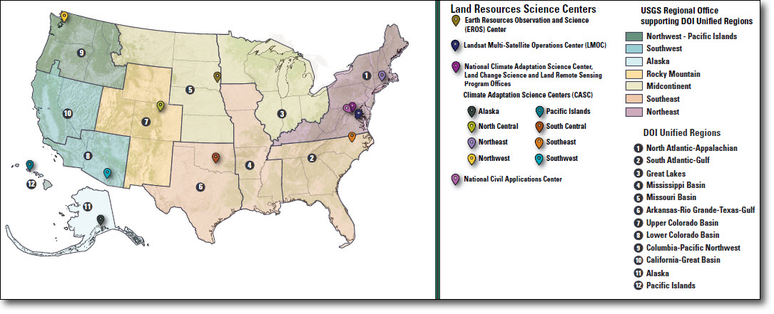
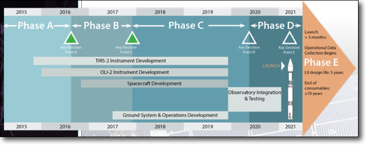
The USGS continued the build, integration, and test phases for the Landsat 9 ground system and remains on track for a Landsat 9 launch in FY 2021. At the end of FY 2019, the USGS met critical milestones including successfully executing the first of a series of Ground Readiness Tests for the Ground Network Element at EROS in South Dakota and the Landsat Multi-Satellite Operations Center (LMOC) at the Goddard Space Flight Center in Maryland. The LMOC receives and monitors spacecraft telemetry, ensures its health and safety, and sends commands to the Landsat 9 satellite. While the LMOC utilizes some of the Landsat 8 software subsystems, the LMOC is new, and this initial test is a significant accomplishment for the incremental delivery of the Landsat 9 ground system.
The USGS, in a joint effort with National Aeronautics and Space Administration (NASA), continues to make progress on developing ground system requirements and acquisition strategies specific to operations and data processing/distribution for the next Landsat mission. In FY 2019, the USGS and NASA successfully completed two checkpoints and both agencies anticipate leveraging rapidly advancing technologies for space systems development, launch and operations, data communications, and cloud-based data management services. The resulting next-generation land-observing capabilities will continue to support advanced, integrated and predictive science by USGS and its partners.
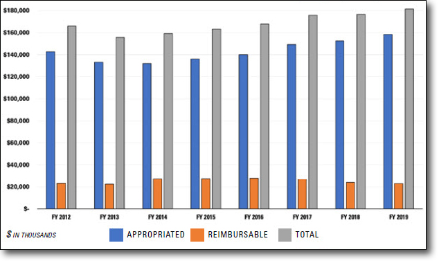
The FY 2019 Land Resources budget supported three programs: National Land Imaging, Land Change Science, and the National and Regional Climate Adaptation Science Centers.
The Energy and Minerals (EM) Mission Area provides impartial science and information for understanding the occurrence and distribution of national and global energy and mineral resources that may contribute to supplies; the potential environmental and socioeconomic effects associated with resource occurrence and use; and the global supply and flow of nonfuel mineral commodities. EM’s research provides a scientific foundation for policy and decision making with respect to resource use, sustainability, environmental protection, and an adaptive resource management approach.
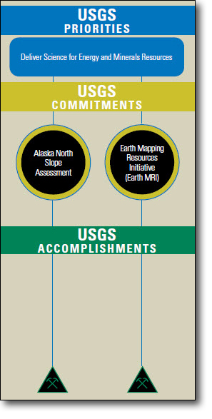
The Energy and Minerals Mission Area delivered science to improve the understanding of energy and mineral resources. Notable accomplishments in FY 2019 in support of the DOI Strategic Plan goals include the following:
The USGS continued technical and outreach activity in support of Secretarial Order 3352: National Petroleum Reserve, a multi-agency effort to update resource assessments for the Alaska North Slope (ANS). Activity included conducting seasonal field work on the North Slope of Alaska, publishing several major papers in technical journals, conducting core workshops for industry, and participating in interviews with local media. Increased technical activity leads to improved understanding of ANS resource potential, which underlies future ANS resource assessments These will be used by policy makers and resource managers to make informed decisions about future resource management on ANS lands. Outreach activity keeps governmental, industry, and public stakeholders informed of our progress and future plans.
The USGS completed the first assessment of undiscovered, technically recoverable gas-hydrate resources on the North Slope of Alaska. The assessment estimated 85 trillion cubic feet (TCF) of undiscovered, technically recoverable gas resources within gas hydrates in northern Alaska. In addition, the USGS participated in the successful drilling and logging of a stratigraphic test well in the greater Prudhoe Bay oil field that confirmed the occurrence of gas hydrates in two reservoirs that are suitable for potential future testing.
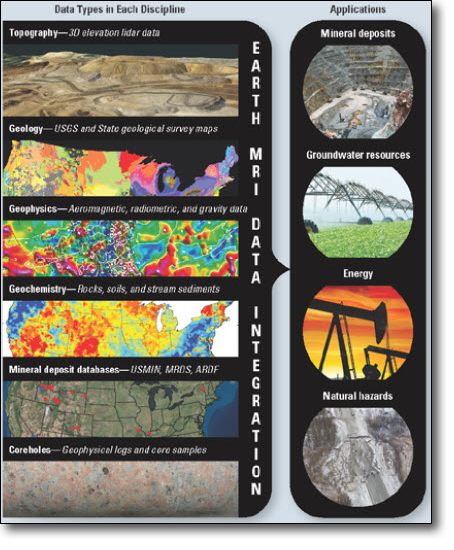
The USGS has collaborated with the Association of American State Geologists to implement the Earth Mapping Resources Initiative (Earth MRI), a program of geologic, geophysical, and topographic mapping to better inform the nation about its critical minerals potential. Earth MRI is being implemented in response to Executive Order 13817 “A Federal Strategy to Ensure Secure and Reliable Supplies of Critical Minerals” and Secretarial Order 3359 “Critical Mineral Independence and Security.” It is a coordinated, long-term strategy to maximize the Nation’s understanding of its subsurface geology and critical mineral resources, by acquiring and interpreting high-resolution three-dimensional (3D) geophysical, geologic, and topographic data across the Nation. This advanced mapping also directly benefits the understanding of other economically valuable mineral resources, energy resources, groundwater resources, geologic hazards, infrastructure dependencies on subsurface geology, and other pressing needs.
The FY 2019 Energy and Mineral Resources Mission Area budget supported two programs: Mineral Resources and Energy Resources.


The Environmental Health Mission Area, via the Toxic Substances Hydrology and Contaminant Biology Programs, work collaboratively to assess and differentiate the environmental contaminant and pathogen exposures that cause actual health risks versus those that are only perceived. Specialized teams of hydrologists, geologists, chemists, biologists, and geographers work together in the field and laboratories across the United States.

The Environmental Health Mission Area provided science to inform land, water, and species management; provided science to safeguard communities; and delivered science for energy and mineral resources. Notable accomplishments in FY 2019 in support of the DOI Strategic Plan goals include the following:
The USGS data and interpretive publications documented the occurrence of environmental mercury in various arctic environments, and in tissue of several species of birds and fish. These data and publications supplied actionable intelligence to land and resource managers on the occurrence, fate/transport, and ecotoxicity of environmental mercury.
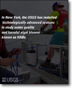
The USGS is a national leader in harmful algal bloom (HABs) science made possible by the state-of-the-art laboratory for algal toxin research at the USGS Water Science Center in Lawrence, Kansas. The Environmental Health Integrated Science Algal Toxin team works with other science centers in the northeast, Great Lakes, Pacific Northwest, Missouri, and Florida to develop emerging approaches for HABs monitoring and assessment, ecotoxicity, sensor testing with the Observing Systems Division of the Water Mission Area, and to evaluate processes that lead to algal toxin outbreaks with the potential to harm aquatic and human health. This information is being used to develop health- and economic-based decision tools, prevention, and mitigation strategies that protect life while balancing the use of water resources for recreational, ecological, and drinking water purposes.
The USGS completed thousands of laboratory analyses to characterize the chemical mixtures of tap water from dozens of sites across the United States. Additionally, a collaborative study with public health epidemiologists and others found bladder cancer risk was associated with water in-take among participants with a history of private domestic well use. These accomplishments provided the first comprehensive science that follows water from the origins of drinking water sources in watersheds and aquifers to the point of exposure at individual taps.
The USGS completed a collection and analysis of drinking water samples for 17 per- and polyfluoroalkyl substances (PFAS) for raw and treated water at 25 public water utilities and for tap water in dozens of locations across the United States. This work adds to a small but growing body of evidence that shows where, when, and at what levels PFAS occur in drinking water resources. PFAS are effective chemicals for many applications and with the recent discovery that they will persist in the environment for decades, decision makers require reliable information on sources, fate and transport, ecotoxicity, and pathways of human exposure.
The USGS published research that showed biologically active contaminants in surface water near a deep well injection site were limited in range to several meters from the spill and could not be detected downstream where water resources are used for recreation, wildlife, and drinking water sources. Another study showed that more than 30 years after an oil spill, hydrocarbons measured in groundwater near Bemidji, Minnesota, have been depleted between 25 and 85 percent. However, some components have remained for many decades and some are expected to remain longer indicating that natural attenuation of petroleum hydrocarbons in groundwater is an effective but slow process.
The FY 2019 Environmental Health Mission Area budget supported two programs: Toxic Substances Hydrology Program and Contaminant Biology Program.
Every year in the United States, natural hazards threaten lives and livelihoods and result in billions of dollars in damage. The Natural Hazards Mission Area (NHMA) works with many partners to monitor, assess, and conduct targeted research on a wide range of natural hazards so that policymakers and the public have the understanding they need to enhance preparedness, response, and resilience.
The Natural Hazards Mission Area provided science to safeguard communities and delivered science for energy and mineral resources. Notable accomplishments in FY 2019 in support of the DOI Strategic Plan goals include the following:
More than 70 newly installed seismic stations began sending data to the ShakeAlert system and approvals for an additional 20 stations have been given to facilitate the continued build-out of the network. Public alerting began in January 2019 using the ShakeAlertLA app developed under agreement with the City of Los Angeles.
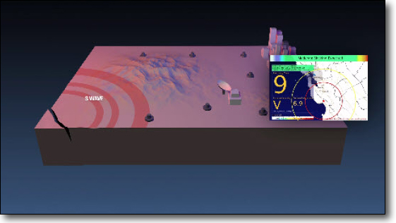
The Alaska Volcano Observatory (AVO) began a 3-year effort to convert all remaining analog stations in the volcano monitoring network to digital telemetry, including sites in the Aleutians. During the summer 2019, a new receiver site at Adak Island was built, and the Great Sitkin and Kanaga subnetworks were successfully converted.
We delivered data and assessments used to establish limits of the ECS. This information, provided in support of the U.S. Department of State, was used to explain the U.S. position on its ECS boundary in the Bering Sea, and we also delivered data for the eastern and western Gulf of Mexico.
Provided 12 post-wildfire debris flow hazard assessments for areas burned by wildfires. These assessments are delivered at the request of partners and were made available within 2 days of receiving a request.
The FY 2019 Natural Hazards Mission Area budget supported six programs: Earthquake Hazards Program, Volcano Hazards Program, Landslide Hazards Program, Global Seismographic Network, Geomagnetism Program, and Coastal/Marine Hazards and Resources Program.

Water information is fundamental to national and local economic well-being, protection of life and property, and effective management of the Nation’s water resources. The USGS works with partners to monitor, assess, conduct targeted research, and deliver information on a wide range of water resources and conditions including streamflow, groundwater, water quality, and water use and availability.
The Water Resources Mission Area provided science to inform land, water, and species management and provided science to safeguard communities. Notable accomplishments in FY 2019 in support of the DOI Strategic Plan goals include the following:
The USGS published two papers that link models of multiple stressor effects on stream health with forecasts of how stream health may change in the future in the southeast Piedmont. The multi-stressor models present a picture of what stream health will look like in the future and what stressors or factors are most important in affecting that health. This information provides valuable guidance to decision makers as they look to address and mitigate any adverse effects of urbanization.
The USGS is now providing daily estimates in all small Hydrologic Unit Code (HUC-12) watersheds nationally for four water budget components: precipitation, streamflow, soil moisture, and recharge. By 2022, nine components of the water budget will be published to support delivery of a National Water Census describing the Nation’s water availability. The water budget describes all the inputs and outputs to a hydrologic system—providing information on when water is available or when there is too much water. By making this information available nationally, the USGS gives decision makers nationally consistent information on water availability in their local area.
The USGS trained over 300 undergraduate, graduate, and post-doctoral students in water-related disciplines. As a foundational component of the Water Resources Research Act (WRRA) Program, students are trained and prepared for future work in water resources research and management fields by participating in research funded by the WRRA Program. Participants in the WRRA-funded research are commonly hired by Federal and State agencies and consultants.
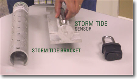
The USGS deployed 294 water level sensors and 44 wave height sensors from Florida to Virginia along the Atlantic coast storm tide network, and 47 rapid deployment gages (RDGs) in advance of Hurricane Dorian (Cat 5). These instruments allow the USGS to document the timing, extent, and magnitude of hurricane storm surge, critical information for determining flood insurance maps and building codes and for calibrating hurricane inundation models that inform community storm response and evacuation plans.
The FY 2019 Water Resources Mission Area budget supported four programs: Water Availability and Use Science Program, Groundwater and Streamflow Information Program, National Water Quality Program, and Water Resources Research Act Program.

Core Science Systems (CSS) leads USGS’s mission as the civilian mapping agency for the Nation. CSS conducts detailed surveys and develops high–quality, highly accurate topographic, geologic, hydrographic, and biogeographic maps and data. The maps allow precise planning for critical mineral assessments, energy development, infrastructure projects, urban planning, flood prediction, emergency response, and hazard mitigation.
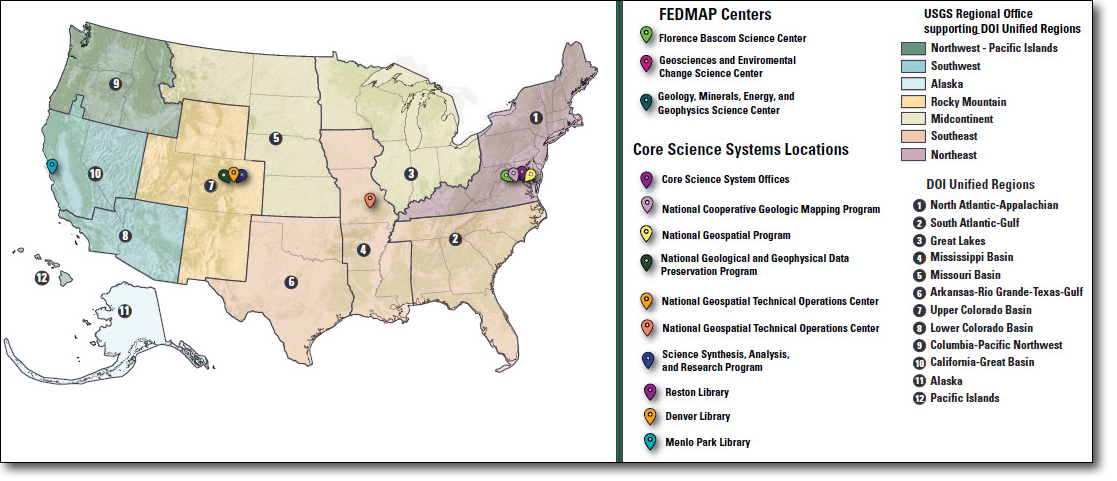
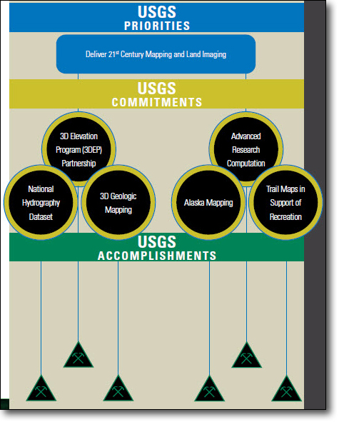
The Core Science Systems Mission Area provided 21st century mapping and land imaging. Notable accomplishments in FY 2019 in support of the DOI Strategic Plan goals include the following:
The USGS made 3DEP data available or in progress for 67% of the Nation. The goal is to reach 100% coverage by the end of FY 2023. These data are transforming infrastructure and transportation planning, utility and pipeline routing, conventional and renewable energy planning, critical mineral and geologic resource assessments, aviation safety, precision agriculture, civil engineering, emergency response, landslide assessment, earthquake and volcano assessments, forestry management, and more. The 3DEP responds to growing needs for high-quality, 3D topographic data representations of the Nation’s natural and constructed features. Through contracts with private industry mapping firms and the growing commercial and industrial uses for the data, 3DEP is creating jobs, generating $690 million in annual benefits to the Nation, and capturing a return on investment of 5:1.
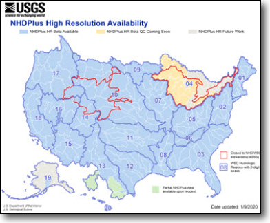
The USGS made the National Hydrography Dataset Plus High Resolution (NHDPlus HR) available for almost 76% of the Nation. The NHDPlus HR will provide a single, scalable hydrography framework for the Nation that contains 10 times more detail than currently available data. The goal is to create an “address system” for America’s inland waterways and catchment areas that drain into streams to enable flood forecasting from the regional to the local, neighborhood level. This framework underpins a host of hydrography-based applications including flood modeling and prediction, chemical spill response, and public safety.
The USGS awarded 14 Cooperative Agreements totaling over $2.0 million to State geological surveys to support geologic mapping for critical minerals as part of the Earth MRI. These agreements are essential to establishing the partnerships between the USGS and State geological surveys needed to acquire the high-quality geologic framework information that is fundamental to the goals of Earth MRI.
The USGS has increased usage of its High Performance Computing system through the addition of 144 users, four training workshops, and has seen over 16 million Central Processing Unit (CPU) hours of use, including the completion of over 1 million jobs increasing the scale, scope, and timeliness of scientific research. The Advanced Research Computation (ARC) enables USGS researchers to gain access to advanced computing technologies and expertise in support of their ever-growing, complex research demands. This has resulted in significant breakthroughs in research data analysis, processing methods, local– to national–scale landscapes and multi-variables.
At the end of FY 2019, the USGS completed interferometric synthetic aperture radar (IfSAR) data collection in Alaska meaning that 100 percent of the high-resolution data was available or in progress. The updated elevation and hydrography data and maps support infrastructure planning, recreation, navigation safety, hazards mitigation, and Arctic wildlife assessments.
The FY 2019 Core Science Systems Mission Area budget supported three programs: National Geospatial Program, National Cooperative Geological Mapping Program, and the Science Synthesis, Analysis, and Research Program.


Science Support, organizationally located within the Director’s Office and the Office of Administration, aids USGS science by providing core business and information functions in the areas of acquisitions and grants, finance, internal controls, communications, budget and performance, monitoring and evaluation of science quality and integrity, information assurance, information management and technology services, and human capital. Science Support consists of the offices listed below.
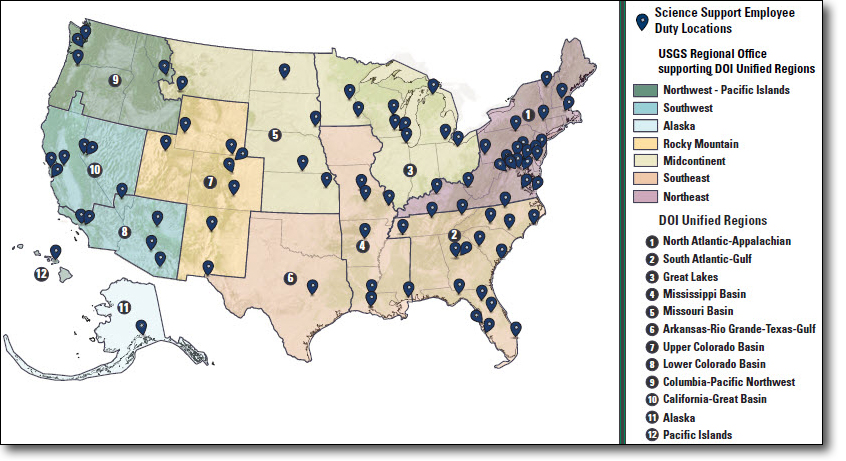
2Data points on Science Support map were derived from Federal Personnel Payroll system (FPPS) duty station locations for personnel assigned to the Director’s Office and Office of Administration. Map includes remote employees who are not located within USGS or GSA facilities.
Office of Budget, Planning, and Integration
The Office of Budget, Planning, and Integration (BPI) secures fiscal resources needed for the USGS to perform its scientific mission and provides in-depth analysis of budget and program performance data for the USGS to understand, anticipate, and respond to shifts in social and political paradigms.
Office of Communications and Publishing
The Office of Communications and Publishing (OCAP) is the “front door” to the USGS. While USGS scientists are conducting in-depth research, OCAP presents their research in a format suitable to the public. OCAP is also in charge of social media and congressional affairs for the USGS.
Office of Diversity and Equal Opportunity
The Office of Diversity and Equal Opportunity (DEO) manages the Equal Opportunity (EO) Program for the USGS in compliance with the Civil Rights Act of 1964 and amended in 1991.
Office of Enterprise Information
The Office of Enterprise Information (OEI) provides the critical Information Management and Technology (IMT) foundation for USGS to facilitate research, data gathering, analysis and modeling, scientific collaboration, knowledge management, and work processes. OEI supports numerous IMT services, such as the USGS information assurance program; infrastructure and cloud services; applications and customer support; and information investment, management, and delivery programs. Additionally, OEI leads critical initiatives such as the DOI Federal IT Acquisitions Reform Act (FITARA) and Cloud Hosting for the USGS.
Office of International Programs
The Office of International Programs provides reliable scientific information about the earth and its resources from an international perspective. This office supports U.S. foreign policy and national security, provides a basis for science diplomacy, improves the scientific basis for managing ecosystems and natural resources, and promotes the competitiveness of our private sector.
Office of Science Quality and Integrity
The Office of Science Quality and Integrity (OSQI) monitors and enhances the integrity, quality, and health of USGS science through executive oversight and development of strong practices, policy, and supporting programs, including Science Integrity, Fundamental Science Practices, Tribal Relations, Youth, Education, Mendenhall Research, Quality Management Systems, and more.
Office of Accounting and Financial Management
The Office of Accounting and Financial Management (OAFM) provides Bureau–wide financial management and administrative support for payments, collections, and travel; technical support, training, and management control for users of the Financial Business Management System (FBMS); and oversight and monitoring of fiscal programs, financial operating procedures, and allocation management. OAFM is also responsible for evaluating the adequacy of the internal control environment within the Bureau, including the effectiveness of existing policies and procedures and operational activities, in addition to performing internal and external financial reporting for the USGS.
Office of Acquisition and Grants
The Office of Acquisition and Grants (OAG) is responsible for managing the Bureau acquisition, financial assistance, and charge card functions.
Office of Human Capital
The Office of Human Capital (OHC) ensures that the USGS has the right people, in the right jobs with the right skills. The office supports employee recruitment, onboarding, performance management, employee and organizational development, pay and benefits, and retirement services. OHC also manages the National Training Center.
Office of Management Services
Office of Management Services (OMS) is responsible for the development and implementation of Bureau-wide policies, procedures, programs, and systems for space, facilities, safety, environmental, security, transportation, supplies, mail, property, energy conservation, and other general services. The OMS provides operational support services for all identified program areas to all USGS staff and office locations.
Office of Policy Analysis
The Office of Policy Analysis (OPA) leads the USGS Directives Management System, the Technology Transfer program, and the patent and licensing program.
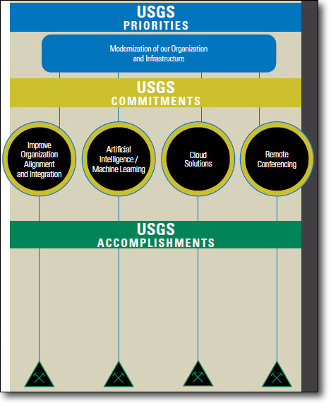
Science Support contributed to modernizing our organization and infrastructure. Notable accomplishments in FY 2019 in support of the DOI Strategic Plan goals include the following:
The USGS developed a comprehensive, scalable Quality Management System (QMS) composed of requirements designed to meet the quality needs of 500 USGS laboratories across the country. Requirements are in review, as the USGS awaits a final report from the National Academies of Science with recommendations on development and implementation of the USGS laboratory QMS. In FY 2019, both the Energy Resources and Mineral Resources Programs fully implemented a QMS. USGS laboratory data will be of known and documented quality, which will help to meet the strategic goals and mission of the Bureau, uphold the Bureau’s scientific reputation and Fundamental Science Practices, and underscore its mandate to provide reliable science to address pressing societal issues. (Note: QMS is a Special Topic discussed later in this section.)
The USGS Associate Chief Information Officer (ACIO) became a member of the National Science and Technology Subcommittee on Technology Machine Learning and Artificial Intelligence. Through work on this subcommittee, USGS provided input on guidance for regulating artificial intelligence and updated the strategic plan for the Federal Government. Participation on the National Science and Technology Subcommittee on Technology Machine Learning and Artificial Intelligence allows the USGS to lead the way in the adoption of artificial intelligence throughout the Federal Government.
The USGS established a collaborative group through the USGS Community for Data Integration to discuss Artificial Intelligence and Machine Learning (AI/ML) usage and opportunities for the USGS. The USGS also completed a baseline inventory of AI/ML activities across the USGS. AI/ML-enabled processes can perform analysis much faster than humans thus allowing increased efficiency and reduced costs. AI/ML also allows scientists to direct actions based on certain criteria for faster response and to dedicate focus to tasks that require a higher level of scientific expertise.
The USGS completed technical requirements necessary to meet the USGS unified video conferencing needs. This project will deliver a high definition (HD) video conferencing system to provide the USGS Director and Executive Leadership the ability to conduct effective collaboration while at geographically dispersed locations of major centers and regional offices. Completing the technical requirements enabled USGS to quantify the acquisition need and pursue working with the Bureau of Reclamation in the procurement of the technical hardware.
The FY 2019 Science Support budget supported two programs: Administration and Management and Information Services.
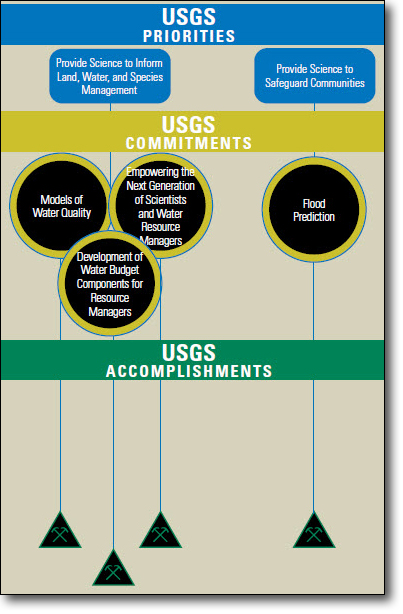
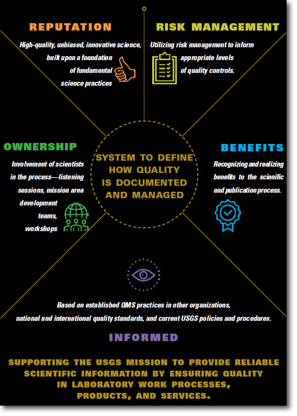
The USGS is creating a consistent and flexible Quality Management System (QMS) designed to ensure quality in laboratory work processes, products, and services. Laboratory science is critical to the mission of the USGS, and once fully implemented, the USGS QMS will provide transparency, traceability, reproducibility, reliability, and defensibility to laboratory activities and results.
The foundation for QMS, demonstrated in the graphic below, to is define how quality is documented and managed in USGS laboratories. It is based on having a strong reputation for high-quality, unbiased, innovative science, built upon a foundation of fundamental science practices. It uses risk management to inform appropriate levels of quality controls. QMS benefits the scientific and publication process. It is informed by QMS practices in other organizations, national and international quality standards, and current USGS policies and procedures. It involves ownership from scientists across USGS through listening sessions, mission area development teams, and workshops.
In FY 2019, approximately 120 USGS employees contributed to the development of the USGS QMS. Listening sessions with 180 USGS laboratories and 30 science centers were held to engage staff from across the USGS. Benchmarking was conducted to compare USGS QMS efforts with other USGS policies and programs; other Federal, academic, and geological survey practices; and international standards regarding quality assurance. Guidance documents, training modules, tools and resources were also drafted in FY 2019 to support the implementation process.

The USGS Facilities Activity provides safe, functional workspace to accomplish the USGS scientific mission with an emphasis on the mission driving facility needs. Funds support rent; basic facility operations; security; facility maintenance in compliance with Federal, State, and local standards; and provide a safe, sustainable working environment for USGS employees, visiting partners, and customers.

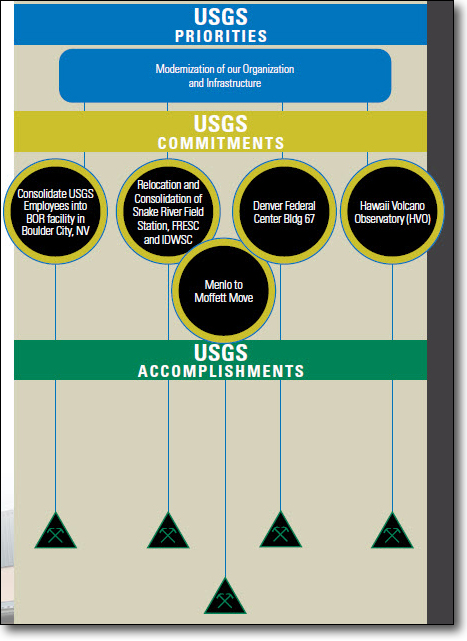
Facilities contributed to modernizing the organization and infrastructure. Notable accomplishments in FY 2019 in support of the DOI Strategic Plan goals include the following:
The USGS completed the revised construction estimate for Building 500 (offices) on the Bureau of Reclamation campus in Boulder City, Nevada. USGS is moving from GSA-leased space in Henderson, NV, to colocated spaces on the Bureau of Reclamation campus in Boulder City. The relocation provides both enhanced collaboration opportunities between the two DOI bureaus as well as lower and more stable facilities costs for the foreseeable future.
The USGS completed the HVO move into new long-term but temporary facilities in Hilo and Keaau, Hawai‘i, following loss of the permanent facility inside Hawai‘i Volcanoes National Park owing to earthquake damage in 2018.
The USGS relocated over 200 employees from Menlo Park to Moffett Field. As background, in fiscal year 2018, USGS began the full implementation-plan to relocate from the Menlo Park Campus operated by the General Services Administration (GSA) to the NASA Ames Research Center and Moffett Field in Mountain View, CA. This 5- to 6-year-long endeavor is in partnership with both GSA and NASA and will ultimately result in an estimated $14 million annual facility savings to USGS including an approximate reduction of 40 to 50 percent of our current footprint once completed.
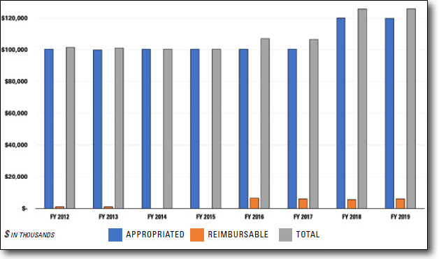
The FY 2019 Facilities budget supported two subactivities: Rental Payments and Operations & Maintenance and Deferred Maintenance and Capital Improvement.3
3The increase in funding between 2017 and 2018 was due to the $11 million increase for the Menlo to Moffett move and an increase in the Deferred Maintenance and Capital Improvement budget of $8 million.
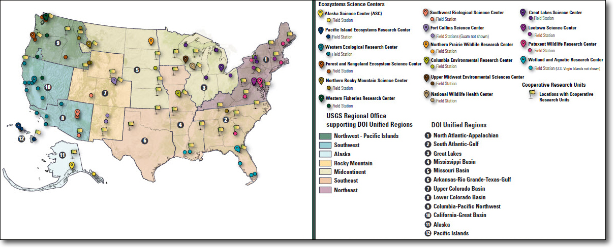
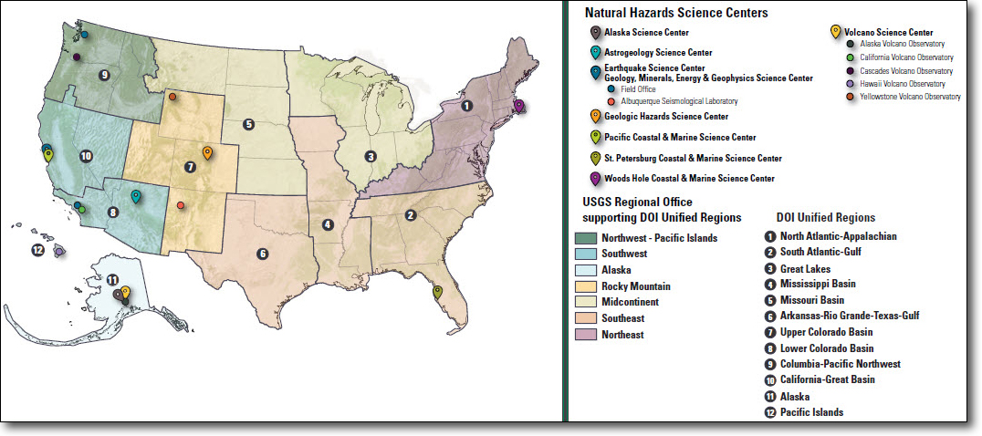
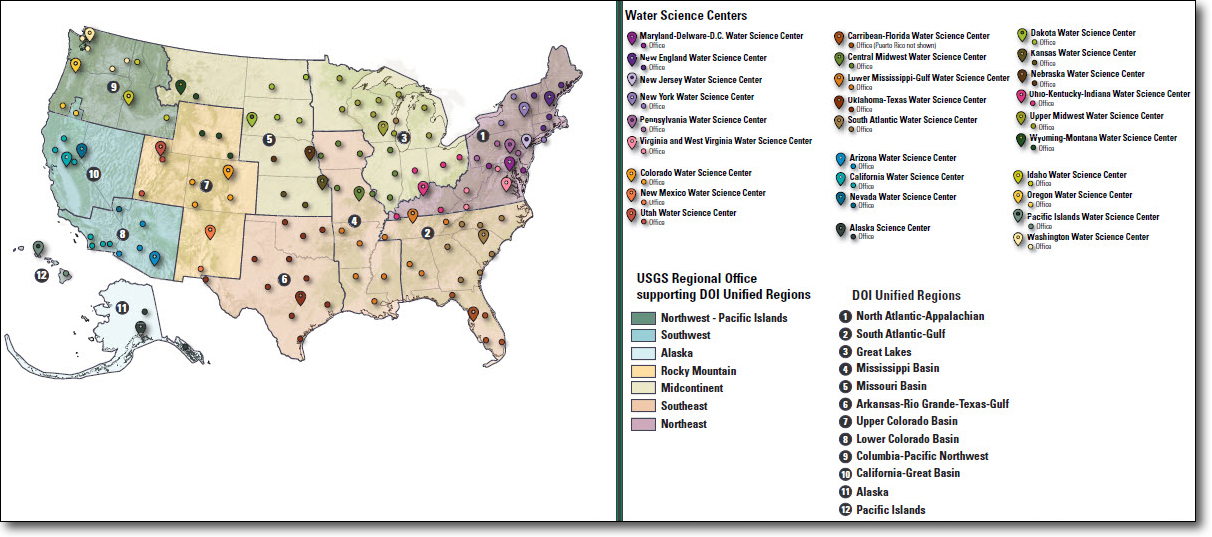
DOI implemented the Interior Regional structure in May 2019 which reorganized 49 regions across 8 bureaus to 12 Unified Regions. The goal of the reorganization is to achieve to greater efficiency, accountability, collaboration and consistency across our bureaus. The reorganization seeks to make joint problem-solving and improved coordination between bureaus and local partners easier and improve the experience for DOI customers. The new DOI regional boundaries are based on watersheds and were adjusted to follow State lines where possible based on feedback received from State Governors.4, 5
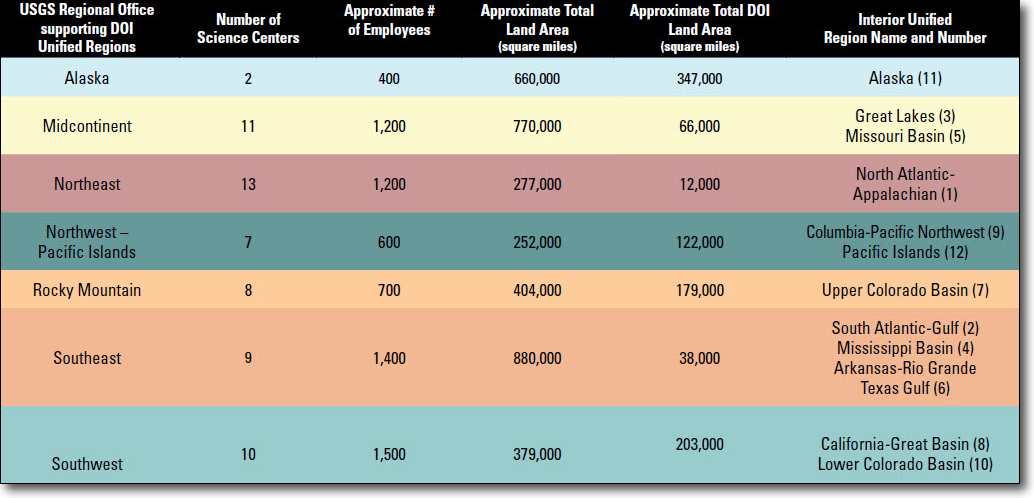
The USGS has regional offices that support the 12 DOI Unified Regions. The USGS regional construct focuses on priorities and issue-based, integrated science to align the USGS with the DOI bureaus and other Federal, State, Tribal, and local agencies, and to enhance partnerships at the local and regional level.
Proximity of the USGS regional offices and science centers to the Interior field offices and to other partners allows USGS scientists and managers to understand and address land and resource management issues and increase opportunities for partnerships and leverage resources. Science centers, located within the regions, ensure the USGS mission is implemented with the high-priority land management, urban planning, and security needs of stakeholders and decision makers.
The USGS has been at the forefront of the DOI’s regionalization activities. USGS Regional Directors served on the original multi-bureau Executive teams in each Interior Region, and in some cases served as the formal Interior Region (IR) Liaisons. In 2019, USGS became the first bureau within the Department to geographically align its regional boundaries to completely match those of the new Interior Regions.
4https://www.doi.gov/employees/reorg/unified-regional-boundaries
5https://www.doi.gov/employees/reorg/faq

2019 Fiscal Year State of the Survey
Developed by Office of Budget, Planning, and Integration
![]() U.S. Department of the Interior |
U.S. Geological Survey
U.S. Department of the Interior |
U.S. Geological Survey
URL: https://pubsdata.usgs.gov/pubs/periodicals/ss2019/ss2019.html
Page Contact Information: Contact USGS
Page Last Modified: Friday, August 07, 2020, 06:44:34 PM