FISC - St. Petersburg
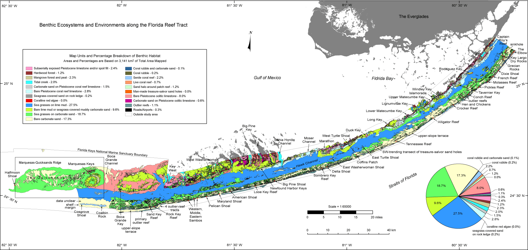
Benthic Ecosystems map and pie chart: The benthic map shows 22 types of habitats identified from the northern Florida Keys to The Quicksands (from Lidz et al., 2005). The habitats were derived from field observation, prior knowledge, and interpreted aerial photomosaics. Three are terrestrial, including a roads/airports map unit. In terms of spatial area mapped, the largest marine habitats are the zones of sea grasses on lime mud (27.5%; Hawk Channel), sea grasses on carbonate sand (18.7%; outer shelf and The Quicksands), and bare carbonate sand (17.3%; outer shelf and The Quicksands). Together, they constitute 63.5% of the total acreage mapped (314,060.21 hectares = 776,032.17 acres = 3,140.5 km2). The fourth largest habitat is the zone of bare lime mud or seagrass-covered muddy carbonate sand (9.6%; inner shelf). All other habitats together equal 26.9% of the mapped area. Precision of map-label placement on coral reefs was verified by overlaying the benthic dataset on top of geo-referenced NOAA raster nautical charts.
The pie chart shows areas and percentages of total area mapped for habitats and urban features (roads/airports). The acreage of each map unit was derived from the original benthic-habitat ArcInfo coverage. The coverage was converted into an ArcView shapefile and re-projected from geographic (latitude/longitude) into UTM coordinates. The re-projection converted the acreage from a measurement of degrees into area (m2 and km2).
The Crystal Report wizard in ArcMap was used to generate the final map-unit sums in m2 and km2. The sums were entered into an Excel spreadsheet to calculate percentages and produce the pie chart.
|
Can't see the printable PDF version? Get the free Adobe Acrobat® Reader. |

![]() U.S. Department of the Interior |
U.S. Geological Survey
U.S. Department of the Interior |
U.S. Geological Survey
URL: [disc] /pubs/pp/2007/1751/professional-paper/figures/benthic-ecosystems.html
Page Contact Information: Feedback
Page Last Modified: December 01, 2016 @ 04:11 PM (JSS)
