FISC - St. Petersburg
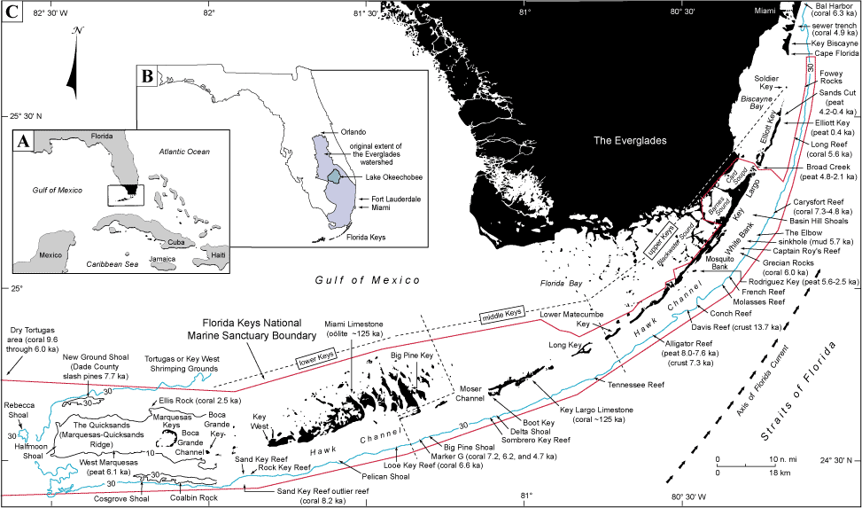
Summary Illustration index map: A summary illustration index map (A, B, and C) shows geography in the Florida Keys area (modified from Lidz, 2004). Dashed lines indicate natural division of the Keys, based on orientation and rock composition, into the lower Keys (oolitic Miami Limestone) and middle and upper Keys (reefal Key Largo Limestone). Age (~125 ka) of the two formations is well established. Holocene reefs lie between the keys and the 30-m contour (blue line), which marks the shelf margin. Red line marks the boundary of the Florida Keys National Marine Sanctuary. Contours are in meters.
(A) Inset shows geographic study area.
Inset (B) shows the location of Fort Lauderdale, where tiered barrier reefs developed offshore ~7 to 6 ka (Lighty, 1977; Lighty et al., 1978, 1982), and the city of Orlando, once the northern boundary of the Everglades watershed (shaded area; e.g., Douglas, 1947). The Everglades watershed today extends from Lake Okeechobee southward.
Primary map (C) shows locations and ages of radiometrically dated materials. Conventional radiocarbon (14C) ages <10 ka are the oldest Holocene dates at the site indicated. The dates shown are uncorrected for variations in production of the 14C isotope used to date the materials and are given in calendar years before present. Two-sigma calibration ranges are given in tables presented in Tile 1. Coral ages show that growth began first to the southwest due to uneven flooding along a westward-sloping shelf (e.g., Perkins, 1977; Lidz et al., 2003).
|
Can't see the printable PDF version? Get the free Adobe Acrobat® Reader. |
