|
 |
 |
Primary Products - Overview Maps & Evolution Overview:
|
|
|
|
|
|
|
|
|
|
|
|
|
|
|
|
|
|
|
|
 |
|
|
|
|
|
|
|
|
|
|
|
|
|
|
|
Tile 1
Tile 1 coordinates:
25°01'49.46" N. 80°31'10.14" W.
25°13'12.35" N. 80°20'35.08" W.
25°08'31.56" N. 80°14'15.98" W.
24°57'01.47" N. 80°24'52.12" W. |
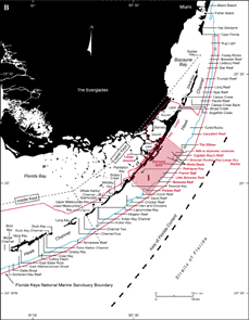
Major Geographic Sites: Tile 1 (upper Keys) includes north Key Largo, Largo Sound, and nearshore Rodriguez Key (Fig. 22A, 22B). Shelf features include a 600-m-diameter sinkhole, Captain Roy's Reef, Grecian Rocks and nearby Key Largo Dry Rocks, White Bank, and Mosquito Bank. Offshore reefs include The Elbow, French, Little Molasses, Molasses, and Pickles Reefs. Carysfort Reef, an offshore reef approximately 9 km northeast of Tile 1, is included in discussion of geology in this sector because of the significant data available for the Carysfort area.
Fully protected "no-take" zones have been established as Sanctuary Preservation Areas (SPAs) at Carysfort Reef, The Elbow, Grecian Rocks, Key Largo Dry Rocks, French Reef, and Molasses Reef (see Marine Sanctuaries). A broad Existing Management Area (EMA) surrounds these and other outer-shelf reefs in Tile 1 and due north of Carysfort Reef (i.e., Turtle Rocks, Fig. 22B). The EMA is demarcated on navigational charts.
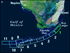 |
| Figure 22. (A) Landsat satellite image of south Florida shows individual tile boundaries (blue rectangles) of this regional study in the Florida Keys National Marine Sanctuary. Tile 1 is highlighted. (B) Index map shows locations of named reefs and shoals in the upper Keys and northeastern middle Keys, delineated by dashed lines. Red rectangle shows geographic boundaries of Tile 1 with its geographic sites highlighted. Because of the amount of data available for the Carysfort Reef area, Carysfort Reef is discussed in the section for Tile 1. Sanctuary boundary is in red; shelf-margin contour (blue) is in meters. [larger version] |
|
 |
continue to: Sector-Specific Studies
|


