FISC - St. Petersburg
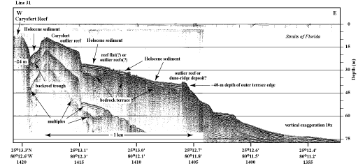
Figure 35. Seismic profile (1991) shows shelf-margin features at Carysfort Reef (from Lidz et al., 2003; Fig. 27). Note that water depth to bedrock in the trough behind the Carysfort outlier reef (24 m) is less than the depth (30-40 m) of the present seaward upper-slope bedrock terrace. Shapes of geologic features in this area are different from those at Sand Key Reef (Fig. 18). The Carysfort outlier reef is thought to represent a different tract of outlier reefs than the tracts seaward of Sand Key (Toscano and Lundberg, 1998; Lidz et al., 2003). 'Multiples' are an artifact common in seismic-reflection data. These reflections replicate those of existing, overlying, geologic surfaces and should not be regarded as representing any subsurface stratigraphic horizon. Latitude and longitude in degrees and decimal minutes based on GPS coordinates. Hours (military time) below coordinates serve as navigational correlation points along seismic line.
|
Can't see the printable PDF version? Get the free Adobe Acrobat® Reader. |

![]() U.S. Department of the Interior |
U.S. Geological Survey
U.S. Department of the Interior |
U.S. Geological Survey
URL: [disc] /pubs/pp/2007/1751/professional-paper/tile1/figures/fig35.html
Page Contact Information: Feedback
Page Last Modified: December 01, 2016 @ 04:12 PM (JSS)
