FISC - St. Petersburg
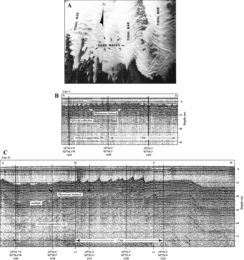
Figure 133. Aerial photo (pre-1990) and seismic profiles (1981) show the sand bedforms and flat Pleistocene bedrock surface that characterize much of The Quicksands in the Gulf of Mexico (from Shinn et al., 1990). (A) Tidal bars are oriented north-south. Sand waves are oriented east-west. Patterns of sand buildups are a response to strong north-south currents. Turtle sea grass (Thalassia testudinum) and various species of a calcareous green alga (Halimeda) populate the dark areas. Corals are absent. Distance across photo is approximately 2.5 km. (B) Seismic profile across middle part of The Quicksands (Fig. 129B) shows low-amplitude (~1 m high) sand waves on shallow (~5 m deep) bedrock. The prominent seismic reflection below the bedrock surface is the Q3 unconformity of Perkins (1977; Table 5). Comparison of photo in (A) with direction of seismic line in profile (B) shows the seismic line paralleled the tidal bars and crossed normal to the sand waves. Sand-wave reflections thus represent true (non-distorted) images. (C) Seismic profile across channel bottom west of Halfmoon Shoal (Fig. 129B) shows large, high-amplitude (~5 m high) asymmetric sand waves resting on deep (~20 m) bedrock. c/c indicates course change. The westernmost sand wave has been smoothed (distorted) by the ship's change in course. For sand-wave height and bedrock-depth comparison, depth scales in (B) and (C) match. Approximate lateral distance based on boat speed of 4 knots. 'Multiples' are an artifact common in seismic-reflection data. These reflections replicate those of existing, overlying, geologic surfaces and should not be regarded as representing any subsurface stratigraphic horizon. Latitude and longitude below vertical time lines on both profiles are given in degrees and decimal minutes based on Loran C TDs (Time Differences). Hours (military time) below coordinates serve as navigational correlation points along seismic line.
|
Can't see the printable PDF version? Get the free Adobe Acrobat® Reader. |

![]() U.S. Department of the Interior |
U.S. Geological Survey
U.S. Department of the Interior |
U.S. Geological Survey
URL: [disc] /pubs/pp/2007/1751/professional-paper/tile11/figures/fig133.html
Page Contact Information: Feedback
Page Last Modified: December 01, 2016 @ 04:13 PM (JSS)
