FISC - St. Petersburg
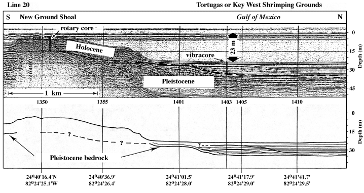
Figure 134. Seismic profile and interpretation show geology across the reef at New Ground Shoal and into Key West Shrimping Grounds, an area of muddy carbonate sediment (see Fig. 129A for location; from Shinn et al., 1990). Rotary core drilled into New Ground Shoal showed underlying Pleistocene corals to be equivalent to those of the Key Largo Limestone of the middle and upper Florida Keys, though the corals were not dated. The fauna of the 8-m-thick Holocene section was similar to that of the Pleistocene and lacked branching corals. The vibracore taken north of the shoal penetrated 8 m of seafloor lime mud and fine carbonate sand lacking corals. Seaward-dipping reflections in area of vibracore were possibly caused by concentrations of mollusc shells, probably deposited by storms. Hours (military time) below vertical time lines on profile serve as navigational correlation points along seismic line. Latitude and longitude below interpretation are given in degrees and decimal minutes based on Loran C TDs (Time Differences).
|
Can't see the printable PDF version? Get the free Adobe Acrobat® Reader. |

![]() U.S. Department of the Interior |
U.S. Geological Survey
U.S. Department of the Interior |
U.S. Geological Survey
URL: [disc] /pubs/pp/2007/1751/professional-paper/tile11/figures/fig134.html
Page Contact Information: Feedback
Page Last Modified: December 01, 2016 @ 04:13 PM (JSS)
