FISC - St. Petersburg
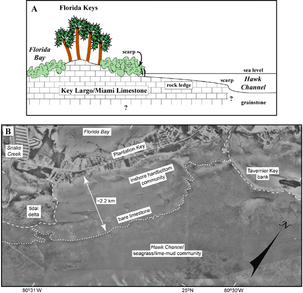
Figure 46. (A) Drawing shows cross section of nearshore rock ledge as presently inferred (modified from Lidz et al., 2006). (B) Aerial photo (1975) shows seaward extent of the nearshore rock ledge (dotted line) in the area of Tavernier Key bank and Plantation Key (upper Keys, Fig. 42B; from Lidz et al., 2003). Note the ledge is much wider than Plantation Key. Maximum extent of the ledge anywhere along the seaward side of the keys is approximately 2.5 km. Its landward edge is coincident with the shoreline of the keys. Sands (dashed lines) of adjacent Snake Creek tidal delta and sandy lime mud of Tavernier Key bank cover parts of the ledge. Sands are thinner on the shoreward part that harbors the inshore hardbottom community (Table 2). The seaward side of the mud bank at Tavernier Key is lined with a narrow zone of coralline red algae (dark ribbon on right edge of dashed line), like the seaward edge of Rodriguez Key bank (see Benthic Ecosystems for Tile 1 and Tile 2). The most extensive habitat on the shelf is the shelf-wide seagrass/lime-mud community that lines the floor of Hawk Channel (see pie chart).
|
Can't see the printable PDF version? Get the free Adobe Acrobat® Reader. |

![]() U.S. Department of the Interior |
U.S. Geological Survey
U.S. Department of the Interior |
U.S. Geological Survey
URL: [disc] /pubs/pp/2007/1751/professional-paper/tile2/figures/fig46.html
Page Contact Information: Feedback
Page Last Modified: December 01, 2016 @ 04:13 PM (JSS)
