FISC - St. Petersburg
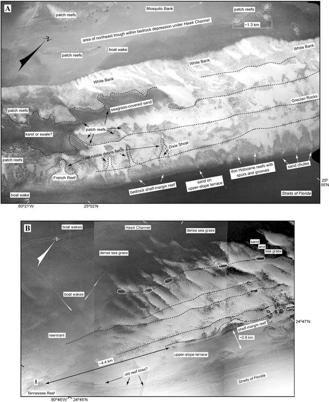
Figure 78. Aerial photos (1975) show various sand-body forms in the Florida Keys (from Lidz et al., 2003). Compare with interpreted Benthic Ecosystems for Tile 1 and Tile 3. (A) The backreef marine sand belt of White Bank (Ball, 1967) lines the landward edge of the outer shelf. Note that linear outer-shelf rock ridges (dotted lines) become sinuous around a possible karst or swale depression. Hundreds of patch reefs line the sinuous ridges. Also note numerous sand chutes at the shelf margin and storm-transported reef rubble behind French Reef, Dixie Shoal, and two unnamed reefs located between them. These features lie seaward of Mosquito Bank and its patch reefs, which are located in Hawk Channel on the inner shelf (upper Keys, Fig. 77B). What caused the patch reefs to grow in the channel is a trough within the channel bedrock (Lidz et al., 2006). Patch reefs colonized its landward edge and bedrock highs within the trough. Although a topographic feature, the trough is not discernible in aerial photos as being deeper than other channel areas. This is one of two inner-shelf topographic troughs that constitute newly recognized coral reef nuclei in the Florida reef record (Lidz et al., 2006). The second trough is located in the same inner-shelf position to the southwest (Fig. 75), along the seaward side of the main bedrock depression under Hawk Channel. (B) Seafloor morphology in vicinity of Tennessee Reef (middle Keys, Fig. 77B). Note that an ~4.4-km-wide break or reentrant occurs in the shelf-margin reef in this area. Also note the wide, essentially flat sand-covered upper-slope terrace and the absence of outlier reefs seaward of the reentrant. 'Tripod' symbol represents location of Tennessee Reef Light. Tennessee Reef is composed of Holocene corals that grew on an isolated section of the Pleistocene (~80 ka) shelf-margin reef. The Tennessee Reef high is surrounded by lower bedrock topography that is similar in depth to bedrock in Hawk Channel (see Bedrock Surface map). Dark lines interpreted as rock ridges can be traced along the shelf margin (dotted lines) and at the seaward edge of the upper-slope terrace (arrows). Ovals mark areas of patch reefs on the landward ridge. There is no topographic trough landward of Tennessee Reef other than the main bedrock depression under Hawk Channel.
|
Can't see the printable PDF version? Get the free Adobe Acrobat® Reader. |

![]() U.S. Department of the Interior |
U.S. Geological Survey
U.S. Department of the Interior |
U.S. Geological Survey
URL: [disc] /pubs/pp/2007/1751/professional-paper/tile5/figures/fig78.html
Page Contact Information: Feedback
Page Last Modified: December 01, 2016 @ 04:14 PM (JSS)
