FISC - St. Petersburg
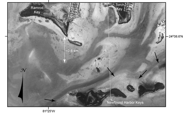
Figure 82. Aerial photo (1991) shows area where the Key Largo Limestone coral reef (Newfound Harbor Keys, middle Keys) is in contact with the Miami Limestone tidal-bar oolite (south parts of Ramrod and Torch Keys, lower Keys) (Hoffmeister and Multer, 1968). The Newfound Harbor Keys represent the westernmost exposure of the Key Largo reef. Black arrows show submerged parts of the Pleistocene reef. Shallow areas around Ramrod and Torch Keys are Pleistocene oolite (Shinn et al., 1989b). Submerged reef and oolite compose the nearshore rock ledge in this area. Note east-west orientation of Newfound Harbor Keys vs. north-south trend of Ramrod and Torch Key tidal bars (see Benthic Ecosystems map and Benthic Ecosystems for Tile 5). Also note pockmarked nature of the shallow oolite vs. smooth surface of the shallow reef. Pockmark holes are filled with seagrass-covered sand. Mangroves fringe the islands.
|
Can't see the printable PDF version? Get the free Adobe Acrobat® Reader. |

![]() U.S. Department of the Interior |
U.S. Geological Survey
U.S. Department of the Interior |
U.S. Geological Survey
URL: [disc] /pubs/pp/2007/1751/professional-paper/tile5/figures/fig82.html
Page Contact Information: Feedback
Page Last Modified: December 01, 2016 @ 04:14 PM (JSS)
