FISC - St. Petersburg
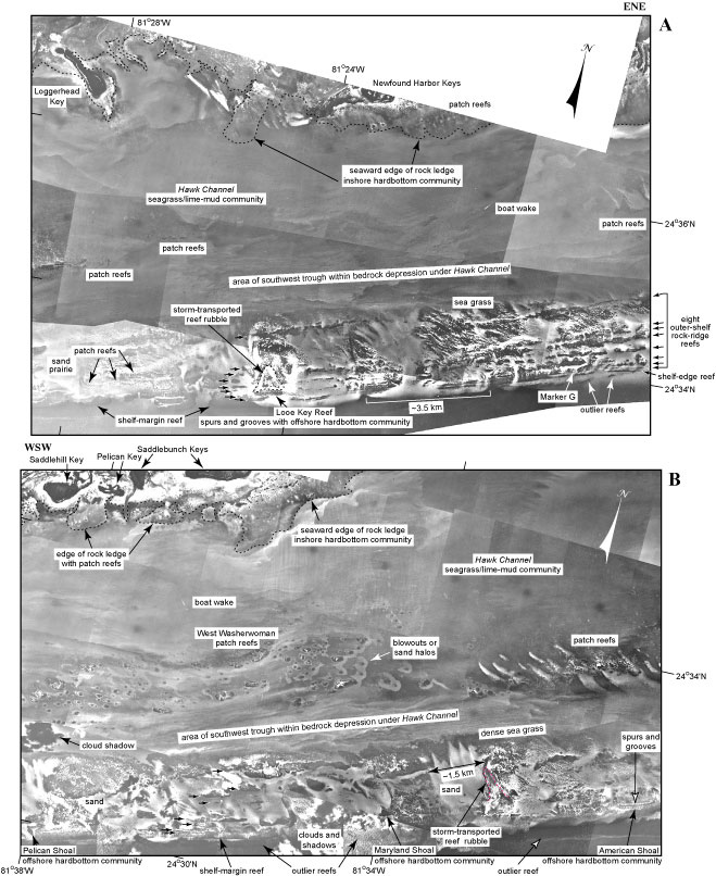
Figure 87. Contiguous aerial photos (1975) show seabed features and habitats seaward of (A) the Newfound Harbor Keys (middle Keys, Tile 5) and (B) the Saddlebunch Keys (lower Keys, Tile 6; from Lidz et al., 2006). Shelf-edge reefs include Looe Key Reef and reefs at American, Maryland, and Pelican Shoals, and at Eastern Sambo. Eastern Sambo lies just out of the photo in (B) at the left edge. Classification of marine habitats and ecosystems follows those of Marszalek (1977) and Lidz et al. (1997b). The parts of the keys visible in these photos are mangrove habitats (see Benthic Ecosystems for Tile 6, and benthic organisms in Table 2). Note that head corals form patch reefs on the nearshore rock ledge (outlined by black dotted lines in A and B). The ledge ranges in water depth from 0 to ~4 m. The seagrass/lime-mud community in Hawk Channel, including the two bedrock troughs, is the largest ecosystem along the entire shelf off the keys (see pie chart). Note the many patch reefs aligned along the landward edge of the trough in both photos. The seagrass/sand community, usually confined to areas of the outer shelf, is the second largest ecosystem. Also note eight linear old reef-line trends on the outer shelf (arrows at right edge of photo in A). They are believed to be narrow coral reefs separated by sediment-filled swales, such as have been cored near Marker G (Shinn et al., 1977a; Fig. 79A). The reef lines are readily visible behind Marker G, can be traced just west of Looe Key Reef (small black arrows on photo A), then become less visible westward until they are again observed more clearly between Maryland and Pelican Shoals (small black arrows on photo B). Offshore hardbottom communities occupy the rock ridges and senile coral reefs at the shelf edge. Senile reefs are those that are not actively accreting reef framework. Also note presence of outlier reefs and storm-transported rubble between American and Maryland Shoals (red dotted line in B). Outlier reefs formed on a 30- to 40-m-deep upper-slope terrace seaward of the shelf-edge reef (Lidz et al., 1991).
|
Can't see the printable PDF version? Get the free Adobe Acrobat® Reader. |

![]() U.S. Department of the Interior |
U.S. Geological Survey
U.S. Department of the Interior |
U.S. Geological Survey
URL: [disc] /pubs/pp/2007/1751/professional-paper/tile6/figures/fig87.html
Page Contact Information: Feedback
Page Last Modified: December 01, 2016 @ 04:14 PM (JSS)
