FISC - St. Petersburg
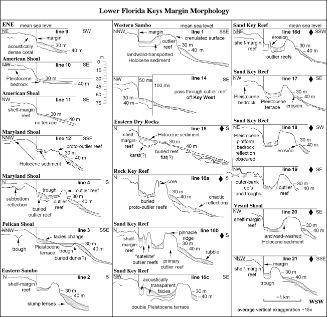
Figure 89. Interpreted seismic reflections representing Pleistocene and Holocene surfaces traced from profiles across shelf margin off the lower Keys (from Lidz et al., 1997a). Note the subdued nature of the reef-and-trough system at the margin (less discernible backreef trough than off the upper Keys, Fig. 90) and expansive system of outlier reefs and unfilled troughs on the upper-slope terrace. Profiles are aligned on what this study uses as the modern margin (vertical line at the 30-m-contour depth) in consecutive order from east to west (see Fig. 91B for locations). Lower Keys are at left. Straits of Florida are at right. Note deep pass between outliers off Key West (scale change from 50 to 100 milliseconds on trackline 14). Corals from four cores recovered from the primary outlier off Sand Key Reef (line 16a) yielded important radiometric ages (Table 5, Table 6, Table 7). Essentially empty troughs behind the outlier reefs indicate that parts of the margin fronted by outlier reefs are progradational, that is, those parts will have expanded seaward rapidly over several kilometers at the point when the troughs become filled (Shinn et al., 1991; Lidz, 2004). Elevations of shelf-edge and outlier reefs are on average at or below the shelf bedrock surface, indicating lack of protective offbank rock-island barriers during shelf flooding. Distance along margin between end profiles is ~65 km. Diamonds indicate profiles used in block diagrams (Tile 7/8). Line 16c was not used in the lower Keys block diagrams due to oblique orientation of the trackline (see Fig. 91B), which distorted width of features in seismic imagery.
|
Can't see the printable PDF version? Get the free Adobe Acrobat® Reader. |
