FISC - St. Petersburg
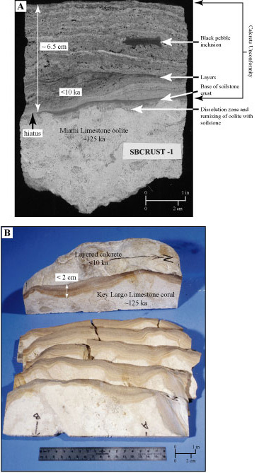
Figure 93. (A) Slabbed drill core shows thick, reddish-brown layered soilstone crust or calcrete that developed as an unconformity on top of the Miami Limestone oolite. The core was taken in the Saddlebunch Keys (lower Keys, Fig. 86C). (B) Rock sample shows the same calcrete unconformity that developed on top of the Key Largo Limestone coral reef. The sample came from the Key Largo Waterway (also called Adams Cut), located between Blackwater and Largo Sounds on Key Largo (upper Keys, Fig. 86B). Note the crust on the oolite (A) is much thicker than the crust on the coral (B). A difference in porosity between the two limestones is thought to cause the difference in thickness between the calcrete accretions. Less porous than the coral reef, the oolite retained rainfall moisture longer, allowing longer periods of layered-calcrete buildup. Reddish and brownish layers in both calcretes represent periods of influx of non-carbonate minerals on African dust. The hiatus or gap in these rock records represents an interval of more than 115 ka during which no marine deposition occurred.
|
Can't see the printable PDF version? Get the free Adobe Acrobat® Reader. |

![]() U.S. Department of the Interior |
U.S. Geological Survey
U.S. Department of the Interior |
U.S. Geological Survey
URL: [disc] /pubs/pp/2007/1751/professional-paper/tile6/figures/fig93.html
Page Contact Information: Feedback
Page Last Modified: December 01, 2016 @ 04:14 PM (JSS)
