FISC - St. Petersburg
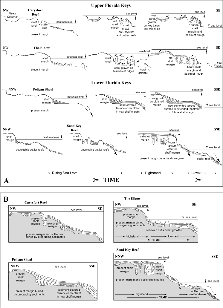
Figure 109. Summary diagram based on seismic data shows present margin surface and two scenarios for possible future development at the four sites modeled: (A) coral growth and sedimentation, and (B) sedimentation with no coral growth. Long curved arrows indicate offshelf sediment transport. Short curved arrows indicate landward sediment transport and infilling of backreef troughs. Carysfort Reef: Filling of the existing trough behind the outlier reef would extend the margin seaward. However, if corals once again grow on the outlier reef, elevation of the new margin could be as high as the present shelf edge, unless corals also resume growth on Carysfort Reef. If corals do not colonize either reef (B), sediment would eventually bury both, and this part of the margin would develop a pronounced slope. The Elbow: If corals renew growth on the linear terrace features, new outlier reefs and backreef troughs could form. If there is no coral growth on these features, sediments should build up on the terrace, raising elevation of its horizontal surface. Pelican Shoal: On the terrace, no hard, sediment-free surface for coral colonization presently exists. Sediments will continue to accumulate, extending the dip angle of the sediment wedge upward and seaward across the terrace. The terrace at this site lies between two outlier-reef segments in a single discontinuous reef tract (Fig. 89, lines 4, 3, and 2). The Pelican Shoal site could become a reentrant in a new shelf margin with infilling of the trough behind the outlier reefs at Maryland Shoal and Eastern Sambo. Sand Key Reef: When the troughs behind the outlier reefs become filled with sediment and/or coalescing fringing reefs, the shelf margin would instantaneously "step" seaward, relative to geologic time. Considering present status of The Elbow and its infilled backreef trough (Fig. 39A, 39B), some parts of the south Florida shelf may have built seaward in this fashion in the past. These scenarios are dependent on the position of sea level and its duration at that position.
|
Can't see the printable PDF version? Get the free Adobe Acrobat® Reader. |

![]() U.S. Department of the Interior |
U.S. Geological Survey
U.S. Department of the Interior |
U.S. Geological Survey
URL: [disc] /pubs/pp/2007/1751/professional-paper/tile7-8/figures/fig109.html
Page Contact Information: Feedback
Page Last Modified: December 01, 2016 @ 04:14 PM (JSS)
