
CONTRIBUTIONS TO THE GEOLOGY OF KENTUCKY
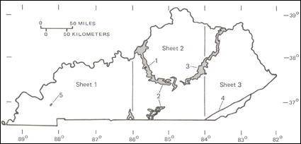
FIGURE 5.--Area of outcrop of Devonian strata in Kentucky (shaded). Numbers refer to geographic areas discussed in text. |
The basal unconformity truncates rocks ranging in age from Late Ordovician on the crest of the Cincinnati arch to Middle and Late Silurian on the flanks of the arch. In most exposures, this unconformity appears planar, as in the vicinity of Jefferson County, where it can be followed without interruption for nearly a mile along the north side of Interstate Highways I-71 and I-264. Where the unconformity truncates rocks of contrasting hardness, as in south-central Kentucky (Simmons, 1967; Kepferle, 1973), the Devonian carbonates and shales are thick over easily eroded Silurian shale but thin over nearby Silurian-dolomite capped cuestas or monadnocks. The limestone and dolomite at the base of the Devonian sequence are also thicker in structurally negative areas such as the Illinois basin and the southern part of the Appalachian basin, and several areas along the Cincinnati arch where syndepositional tectonism appears to have exerted minor influence. The erosion that preceded the Middle Devonian accumulation of carbonate rocks took place during an interval of mild tectonic warping along structures such as the incipient Cincinnati arch and the tighter folds that parallel or are normal to the present strike of the Appalachian Valley and Ridge province and the Pine Mountain thrust fault.
The Devonian rocks of Kentucky accumulated in a gradually deepening epeiric sea (Kepferle, 1977, p. 41; Jordan, 1980; Ettensohn and Barron, 1981, p. 59, 69). This is inferred from the upward facies change from carbonate at the base to clay-rich shale at the top and from the lack of evidence of subaerial exposure within the sequence.
For purposes of discussion, the Devonian rocks are grouped in five general areas of outcrop (see fig. 5): (1) the west flank of the Cincinnati arch, where the rocks dip gently westward into the Illinois basin along a line extending southward from the Ohio River in Jefferson and Oldham Counties to the sharp eastward bend in the outcrop in Nelson and Larue Counties; (2) the faulted and warped Cumberland Saddle area of outcrop extending eastward and northeastward through Madison and Estill Counties and southward in discontinuous exposures to the Tennessee border; (3) the northward-extending outcrop on the east flank of the Cincinnati arch where the bedrock dips gently eastward into the Appalachian basin; (4) the discontinuous exposures in the sole of the Pine Mountain thrust fault on the west flank of Pine Mountain; and (5) minor exposures beneath the more recent sediments in the faulted Mississippian Embayment area of the Jackson Purchase region of Marshall and Lyon Counties. The carbonates are thickest in the northern part of area 1 and in area 2. The shale is thickest in the northern parts of areas 3 and 4. Thickness, composition, and paleocurrent data suggest that the source of terrigenous elastics lay to the east during much of the Devonian period (Kepferle, Lundegard, and others, 1978; Potter and others, 1979).
The Jeffersonville Limestone consists mostly of olive-gray, brownish-gray, and medium- to light-gray fossiliferous limestone, which is in part dolomitic. Chert in thin irregular stringers has locally replaced the limestone; some of the fossils have been silicified. Stylolites are conspicuous in quarry exposures. The entire thickness of the Jeffersonville Limestone, 18 to 30 ft, is exposed in several abandoned quarries, along Interstate Highways I-71 and I-264, and along U.S. Highway 42 between Goose Creek and Little Goose Creek; the thickest exposures are at the Falls of the Ohio, where whole and broken fossils are conspicuous. The Jeffersonville Limestone pinches out beneath an unconformity southward against the northwest-facing flank of the northeast-trending Lyndon syncline (Kepferle, 1974). Zonation of the unit based on fossils has been proposed by numerous workers, including Oliver (1960), Perkins (1963), Stumm (1964, p. 7-9), and Conkin and Conkin (1972, p. 311-317). The detailed ecological relations of some of the corals in the Jeffersonville Limestone at the Falls have been studied by Kissling and Lineback (1967). Evidence of the shallow-water origin of the initial carbonates is provided by abundant large colonial corals in the basal part of the Jeffersonville Limestone.
The Jeffersonville is correlative with the Columbus Limestone of Ohio, the Onondaga Limestone of New York, the Huntersville Chert of the subsurface in eastern Kentucky, West Virginia, and Pennsylvania, the Detroit River Group of northwestern Ohio and the Michigan basin, the Grand Tower Limestone of Illinois, and, locally in south-central Kentucky, part of the Boyle Dolomite (Limestone) (Oliver and others, 1969).
The Silver Creek Limestone Member of the Sellersburg Limestone is bluish gray, olive gray, and light greenish gray on freshly exposed surfaces, and it weathers pale yellowish brown, yellowish gray, olive gray, and yellowish orange. It is fine grained, clayey, dolomitic, and locally cherty; it tends to fracture to smooth conchoidal faces. Fossils are rare to abundant in sparse lenses, and include brachiopods such as Chonetes yandellanus, gastropods, pelecypods, and trilobites; bioturbation has imparted a mottled appearance. The contact with the underlying Jeffersonville Limestone is unconformable and locally is marked by phosphatic pebbles, quartz sand, pyrite, and glauconite. The unit is thickest on the Indiana shore of the Ohio River opposite McAlpine Dam, where as much as 15 ft of limestone is preserved in individual beds. A complete thickness of 7.5 ft is exposed along the north side of Interstate Highways 1-71 and 1-264, but the unit is locally missing between the overlying Beechwood Limestone Member of the Sellersburg Limestone and the underlying Jeffersonville Limestone. The Silver Creek Limestone Member has not been identified where the Jeffersonville is missing, south of the vicinity of Louisville. The Silver Creek is correlated with the Stafford Limestone Member of the Skaneateles Formation (Hamilton Group of New York) by Oliver and others (1969).
The Beechwood Limestone Member of the Sellersburg Limestone is light gray to greenish gray; it weathers moderate yellowish brown, light to medium brown, and light olive gray. Fossil fragments and whole fossils are common in a micritic to sparry matrix and are characterized in part by distinctive three-vaned columnal plates of the crinoid commonly called Dolatocrinus; silicified fragments of brachiopods and horn corals are locally abundant where the formation has weathered to a chert-littered terra rossa. Reference sections and correlation are discussed by Orr and Pollock (1968), who follow Indiana usage (Patton and Dawson, 1955) in designating the unit a member of the North Vernon Limestone. The thickness in the vicinity of Louisville ranges from 2 to 11 ft. A lag concentration of phosphatic pebbles, quartz sand, pyrite, and glauconite occurs locally at the contact with the underlying unit, which in the vicinity of Louisville is either the Silver Creek Limestone Member of the Sellersburg Limestone or the Jeffersonville Limestone. In Jefferson and Oldham Counties, the Beechwood is overlain unconformably by the New Albany Shale.
New Albany, Chattanooga, and Ohio Shales, Boyle Dolomite (Limestone), and Sellersburg Limestone (MDnb). Southward from Jefferson County (area 1 in fig. 5), this unit consists of the Beechwood Limestone Member of the Sellersburg Limestone and the overlying black New Albany Shale. Together they total less than 100 ft thick, of which the Beechwood is less than 10 ft. The Beechwood lies above an unconformity that truncates successively older rocks southward to Marion County: the Silver Creek Limestone Member of the Sellersburg Limestone and Jeffersonville Limestone (Early to Middle Devonian), and the Louisville Limestone, Waldron Shale, Laurel Dolomite, Osgood Formation, and Brassfield Dolomite (Early to Middle Silurian). In this area, the Beechwood is too thin or too discontinuous to delineate consistently on the quadrangle maps; therefore the unit has been mapped with the overlying New Albany Shale, although the Beechwood is separated from the New Albany by a locally distinct unconformity. In broad flat areas that make up the eastern part of the outcrop belt in these areas, residuum on thin remnants of the New Albany Shale is difficult to distinguish from the terra rossa of the weathered Beechwood.
The Boyle Dolomite and the Beechwood Limestone Member of the Sellersburg Limestone are considered equivalent. The boundary between these units is arbitrarily placed along the northwest part of the Cumberland Saddle. In and near the faulted area of the saddle (area 2, fig. 5), however, the Boyle may include at its base equivalents of the Jeffersonville Limestone, as shown by the generalized correlation diagram at the base of sheet 2 of the geologic map. The thickness of the Boyle is extremely variable and probably reflects irregularities on the surface on which it lies unconformably. The unit is thickest in the vicinity of the faulted area in south-central Kentucky (area 2), where as much as 60 ft of Boyle Dolomite has been mapped in the Stanford quadrangle, Lincoln County (Shawe and Wigley, 1974). The Boyle pinches out to the northeast on the east side of the Cincinnati arch (area 3) and has not been mapped with certainty north of Fleming County. It is also missing beneath the Chattanooga Shale over a wide area in the southern part of the Cumberland Saddle. In the Raywick quadrangle, the Boyle thickens to 26 ft in an erosional channel in the underlying shale of the Silurian Osgood Formation.
In the Raywick quadrangle, the Boyle consists of limestone, dolomite, and sandstone. The limestone is greenish gray to light gray or light olive gray and is composed of coarse-grained fossil fragments that weather white in a moderate-yellowish-brown or light-brown matrix of silt-sized calcite; the combination of colors results in a very pale yellowish brown to grayish orange appearance. The limestone contains some chert. The dolomite is grayish yellow to pale yellowish orange and moderate yellowish brown to dark yellowish orange; it contains some quartz sand and occurs near the base of the unit, as well as locally at the top, where the unit is thickest. In thin exposures, less than 1 ft of limestone overlies as much as 1.3 ft of dark-yellowish-orange calcareous sandstone, which contains a lag concentrate of sandstone pebbles as much as 2 inches in diameter as well as pyritic phosphatic debris. Beds in the unit are commonly 0.2 to 0.6 ft thick in discontinuous sets 2 to 3 ft thick; the unit is locally shaly weathering. Common fossils include crinoids, bryozoans, and horn corals. To the east, in the Stanford quadrangle, dolomite of the Boyle Limestone is light olive gray to light brownish gray and weathers on exposures to yellowish brown, olive gray, or olive black. Chert occurs in irregular layers and nodules, as much as 0.3 ft thick, which are pale brown to medium gray and weather light gray to white. Original textures of the limestone are preserved locally and include oolites and fossil fragments. Cherty beds locally occur at the top of the Boyle, at the base of the Boyle, or throughout.
Subdivisions within the Boyle are valid for small areas and may be useful for some regional correlations. Variations in lithology, both areally and in vertical succession from place to place within the Boyle, preclude generalization. The Boyle Dolomite in Kentucky has also been called the "Corniferous" Limestone, the Onondaga Limestone, and the Hamilton Limestone.
The New Albany Shale is an organic-rich black shale that contains thin beds of greenish-gray shale in two zones, one near the top and the other near the base. In Jefferson and Oldham Counties, the New Albany is mapped separately and attains a thickness of 110 ft. It is mainly Late Devonian in age, although some of the lowermost beds in Madison County are Middle Devonian and the uppermost fraction of a foot to 25 ft or so in exposures on the west side of the Cincinnati arch is Early Mississippian. Fossils include the sporomorph commonly called Tasmanites, microfossils such as conodonts and radiolaria, carbonized and silicified wood fragments, fish scales, teeth, and bones, and linguloid and orbiculoid brachiopods. Trace fossils are common in the greenish-gray shale beds. Phosphatic nodules are locally common at or near the top of the shale. The New Albany Shale thins to the southeast from 110 ft in Jefferson County toward the Cincinnati arch, where thickness ranges from 20 to 40 ft. The New Albany is continuous with the Chattanooga Shale southward in the Cumberland saddle (area 2, fig. 5), where the shale locally thins to less than 4 ft. The New Albany thickens northeastward (area 3) to Olympia (Bath County). A tongue of Bedford Shale (Upper Devonian and Lower Mississippian) extends southwestward from Ohio into the upper part of the black shale sequence in this area; there the black shale is divided into the Sunbury Shale, 10 to 25 ft thick, above the tongue and the Ohio Shale below the tongue (see generalized stratigraphic diagram at the top of sheet 3). Northward, in Lewis County, the Ohio Shale reaches a thickness of 260 ft and the Middle Devonian carbonates are missing beneath the black shale, which there lies on Middle Silurian dolomite.
Chattanooga and Ohio Shales (MDc).-Along Pine Mountain (area 4, fig. 5) the lower part of the black shale sequence is everywhere cut by the Pine Mountain thrust fault. Here the thickness of the Devonian shale sequence preserved along the fault is as much as 1,000 ft. Where the Bedford Shale, Berea Sandstone, and overlying Sunbury Shale are mapped separately, mainly along the northern part of the fault, the unit includes only the Ohio Shale. To the southwest along the Pine Mountain exposures, where the Bedford thins and the Berea disappears, the black shale includes equivalents of the Sunbury Shale at the top and is called the Chattanooga. The eastward thickening of the Ohio and Chattanooga Shales in Pine Mountain is accompanied by an increase in the thickness and number of greenish-gray shale beds, an increase in the silt content of the shale, and an overall decrease in the organic content of individual black shale beds. Devonian chert and clay (Dcc).-Weathered Chattanooga Shale and chert and clay residue of the underlying Middle and Lower Devonian limestone is exposed in faulted localities in Marshall and Lyon Counties in western Kentucky (area 5, fig. 5) (Rogers, 1963; Lambert and MacCary, 1964; Fox and Olive, 1966).
NEXT || PREVIOUS || Return to STRATIGRAPHY