
CONTRIBUTIONS TO THE GEOLOGY OF KENTUCKY
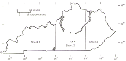
FIGURE 3.--Area of outcrop of Silurian strata in Kentucky (shaded). |
During the cooperative mapping program, five Silurian formations were recognized on the west side of the Cincinnati arch and three on the east. Only the basal unit, the Brassfield Dolomite, is present on both sides.
For the purposes of discussion, the outcrop area is separated into three parts: (1) the western outcrop belt, (2) the eastern outcrop belt, and (3) other exposures.
The total thickness of the Silurian within this outcrop belt ranges from 0 to about 180 ft, as a result of erosion along the superjacent unconformity. The rocks are thickest west of Mount Washington and thinnest at the southern end of the outcrop belt, where they pinch out. Because of this erosion, the Louisville Limestone is at the top of the Silurian section throughout the northern two-thirds of the outcrop belt, whereas older formations occur at the top in the southern part of the belt. This description of the western outcrop belt has been abstracted from a recent summary by Peterson (1981).
Brassfield Dolomite.--South of Mount Washington, the Brassfield Dolomite is thin-bedded gray dolomite that contains nodules and discontinuous beds of chert, which probably constitute less than 5 percent of the formation, and a few thin beds of shale in the upper few feet. Glauconite is common in both the dolomite and the chert. Fossils, which occur in both the dolomite and the chert, are sparse to abundant and are generally indistinct and poorly preserved; they include brachiopods, crinoid columnals, horn corals, and colonial corals. The thickness ranges from about 10 to about 30 ft where the entire formation is present.
North of Mount Washington, the Brassfield is much thinner and is composed of limestone, interbedded dolomite, and minor chert; here it has been called the Brassfield Formation. The limestone, which accounts for more than 50 percent of the formation, contains abundant crinoid columnals, brachiopods, bryozoans, and solitary and colonial corals. The dolomite is finely crystalline and unfossiliferous. The bedding tends to be irregular and disrupted. Glauconite is sparse to common in both the limestone and the dolomite. The Brassfield in this area ranges in thickness from 0 to about 10 ft but is commonly 2 to 3 ft thick.
The basal contact is an erosional unconformity of small relief, probably less than a few feet, over most of the western outcrop belt, but it may be conformable in a small area near Bardstown (Peterson, 1981).
Osgood Formation.--The Osgood Formation is composed of greenish-gray clay shale and gray clayey dolomite. Shale makes up about 90 percent of the unit, is commonly dolomitic, and weathers with a blocky fracture to a plastic clay; less commonly it is crudely fissile. The dolomite occurs in thin interbeds in the shale and is concentrated near the top and at the base. Where the entire unit is present the Osgood ranges in thickness from about 10 to about 50 ft. It is thickest near Bardstown and thinnest in the northern part of the outcrop belt. The basal contact appears to be gradational with the underlying Brassfield Dolomite through a few inches to a foot or so by interlayering of shale and dolomite south of Mount Washington, and is commonly sharp and apparently conformable to the north. Rexroad (1967), however, concluded on the basis of missing conodont zones that the Osgood and underlying Brassfield are separated by an unconformity.
Laurel Dolomite.--The Laurel Dolomite is composed 95 percent or more of gray dolomite with minor greenish-gray shale and sparse gray limestone. The Laurel is divisible into six remarkably persistent and distinct subunits throughout most of the outcrop belt (Peterson, 1981). The subunits are (1) a thinly interbedded dolomite and shale at the base, (2) a thin shale, (3) a vuggy-weathering dolomite, (4) a smooth weathering dense dolomite, (5) a thin-bedded dolomite, and (6) a dolomite oolite at the top. Fossils, which are sparse to abundant, are commonly strongly dolomitized and poorly preserved. Recognizable forms include crinoid stems and columnals, brachiopods, and trilobites. The Laurel has a minimum thickness of about 40 ft; maximum thickness ranges from about 55 ft in the northern half of the outcrop belt to 65 ft in the southern half, where it is overlain by Waldron Shale and thus was not eroded before deposition of the Devonian rocks. The basal contact with the underlying Osgood Formation is gradational by interlayering of shale and dolomite through several inches to as much as 3 ft.
Waldron Shale.--The Waldron Shale is composed of greenish-gray shale and minor gray dolomite; probably at least 95 percent is shale. The shale is dolomitic and weathers with angular fracture or crude fissility, eventually producing a plastic clay. The dolomite is clayey and occurs in irregular masses, lumps, and thin discontinuous beds. Fossils, which are sparse in both the shale and the dolomite, include brachiopods, crinoid columnals, gastropods, and bryozoans. The Waldron Shale ranges in thickness from 9 to 15 ft where overlain by the Louisville Limestone and not eroded prior to deposition of the Devonian sediments. The basal contact with the underlying Laurel Dolomite is conformable and sharp.
Louisville Limestone.--The Louisville Limestone is mostly thin-bedded gray dolomitic limestone and gray calcitic dolomite, commonly in lumpy or irregular beds. Shale, in partings and very thin beds, constitutes a few percent, and very sparse chert is present in nodules and thin layers. South of La Grange, most of the Louisville is finely crystalline calcitic dolomite; the sparse fossils are dolomitized and include crinoid columnals, brachiopods, horn corals, and colonial corals. North of La Grange, the Louisville is mostly a dolomitic limestone containing abundant, well-preserved whole and fragmental fossils, including horn corals, colonial corals, stromatoporoids, brachiopods, bryozoans, and crinoid columnals. The upper contact of the Louisville is a regional erosional unconformity or paraconformity. The maximum thickness, about 95 ft, occurs in a small area about 10 mi southwest of Mount Washington; it is thinner to the north and south and is completely removed below the unconformity in the southern part of the western outcrop belt. The basal contact with the Waldron Shale is conformable and generally sharp.
The Silurian rocks overlie Ordovician rocks with apparent conformity, although faunal studies have suggested that the uppermost Ordovician is not present (McDowell, 1983, p. 19). No evidence of erosion is discerned except for a conglomerate at the base of the Silurian composed of underlying Ordovician rocks near Berea (Weir, 1967). Rexroad (1967) has suggested that a hiatus exists at the base because of the thinness of the lowest Silurian conodont zone. The upper contact of the Silurian system is everywhere a regional erosional unconformity.
The total thickness of the Silurian within the outcrop belt ranges from 0 to 300 ft. It is generally thickest at the north and thinnest at the south end. This thickness range is the result of erosion along the superjacent unconformity.
Most of the information used in the following description of the Silurian rocks in the eastern outcrop belt has been abstracted from a recent summary by McDowell (1983); some is taken from various geologic quadrangle maps. McDowell has slightly revised the terminology used during the mapping program and on the State geologic map (fig. 4), but the nomenclature used herein is that shown on the map.
Brassfield Dolomite.--The Brassfield Dolomite is composed of thick- to thin-bedded gray dolomite with minor interbedded greenish-gray shale and, locally, chert nodules and lenses. The shale is more abundant in the upper part. Fossils are sparse to abundant and include crinoid columnals, brachiopods, horn corals, colonial corals, trilobites, pelecypods, and bryozoans. Gordon and Ettensohn (1984) have described the depositional environment of the Brassfield in eastern Kentucky.
The top of the Brassfield is distinct only south of Owingsville, Bath County, where the overlying Crab Orchard Formation is dominantly shale. North of Owingsville, dolomite beds are more abundant in the lower part of the Crab Orchard, and the top of the Brassfield, as characterized by fossils (the "bead bed" of some authors; see Gordon and Ettensohn, 1984, p. 105) at the type section, is not at a lithologic contact. Consequently, in the northern part of the outcrop belt a contact was mapped at the top of the dominantly dolomitic lower part of the Silurian section and the unit was labeled "Lower part of Crab Orchard Formation and Brassfield Formation" without specifying the top of the Brassfield. McDowell (1983) has subsequently modified the stratigraphic nomenclature to match the mappable units (fig. 4).
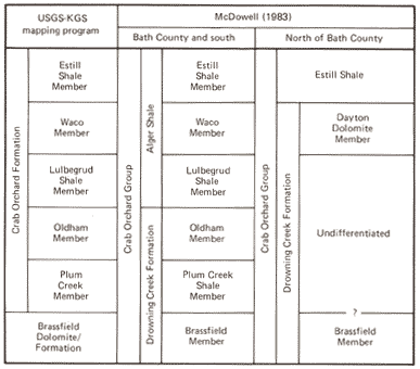
FIGURE 4.--Recent revisions in Silurian nomenclature in Kentucky. |
As shown in figure 4, the Brassfield Formation was reduced in rank to member, and a new formation, the Drowning Creek, was erected to reflect the units shown on the geologic quadrangle maps (McDowell, 1983, p. 7-11). The Drowning Creek Formation, described from exposures in Estill County, includes at the top dolomite members of the Crab Orchard Formation as used during the mapping program: Oldham Member south of Bath County and Dayton Dolomite Member to the north (see fig. 4). This revision separates the Silurian of eastern Kentucky below the Bisher Dolomite into two mappable units of lithologic homogeneity: predominantly dolomite below and predominantly shale above (McDowell, 1983, p. 18).
The Brassfield ranges in thickness from about 9 to 28 ft within the areas where the top can be definitely located and where it has not been truncated by the unconformity at the top of the Silurian.
Crab Orchard Formation.--The Crab Orchard Formation, as used during the mapping program, is composed mainly of greenish-gray clay shale with minor amounts of dolomite, which occur mostly near the base. In the southern part of the outcrop belt, south of Owingsville, the Crab Orchard is composed of five members, which are, from oldest to youngest, (1) Plum Creek Member, greenish-gray clay shale ranging from 2 to 12 ft in thickness, (2) Oldham Member, gray fossiliferous dolomite interbedded with greenish-gray clay shale, which ranges in thickness from 3 to 15 ft, (3) Lulbegrud Shale Member, greenish-gray clay shale with minor amounts of dolomite which ranges in thickness from 2 to 21 ft, (4) Waco Member, interbedded greenish gray clay shale and lesser fossiliferous dolomite which range from about 2 to 13 ft in thickness, and (5) Estill Shale Member, mainly greenish-gray clay shale, with a few brownish-gray, inch-thick, dolomite beds and lenses, which ranges in thickness from 60 to 170 ft. The Plum Creek, Oldham, and Lulbegrud Shale Members are not readily identifiable north of Owingsville, where the Waco Member pinches out.
The basal beds of the Waco reappear 2 to 3 mi northward, as the Dayton Dolomite Member, where they form the top of the dominantly dolomitic basal Silurian map unit now named the Drowning Creek Formation. The Estill Shale Member forms the upper part of the Crab Orchard in the northern part of the eastern outcrop belt.
The Crab Orchard Formation is conformable with the underlying Brassfield Formation, and the contact south of Owingsville is sharp or gradational through a few inches.
Bisher Dolomite.--The Bisher Dolomite (Sb) is a thick- to thin-bedded gray dolomite with locally abundant brachiopods, trilobites, gastropods, bryozoans, crinoid columnals, and scattered algal heads. The unit is everywhere truncated by the unconformity at the top of the Silurian. It has a maximum thickness of about 100 ft at the Ohio River and thins to pinch-out about 10 mi to the south; it reappears locally southward beyond the pinch-out as thin erosional remnants. The Bisher is conformable on the underlying Crab Orchard Formation with a sharp contact.
NEXT || PREVIOUS || Return to STRATIGRAPHY