
CONTRIBUTIONS TO THE GEOLOGY OF KENTUCKY
FIGURE 8.--Area of outcrop of Pennsylvanian strata in Kentucky (shaded). |
The Pennsylvanian rocks of the two basins are lithologically similar and consist largely of sandstone, siltstone, and shale. Coal beds and thin marine shale and limestone units are widespread and occur in most parts of the stratigraphic section. These deposits indicate that in Pennsylvanian time Kentucky was near sea level, alternately covered by lakes, extensive swamps, shallow bays, and estuaries. Thus piedmont, alluvial, and coastal-plain environments extended across the State at times during the Pennsylvanian, resulting in the deposition of the strata of the two great coal fields.
The western Kentucky coal field contains, at the top of the section, a few hundred feet or more of strata of Permian age (Kehn and others, 1982). These beds are described in the section on the Permian System.
There is no consensus concerning the position and nature of the boundary between the Mississippian and Pennsylvanian Systems in southeasternmost Kentucky. Stratigraphic studies demonstrate that the largely Mississippian Pennington Formation intertongues with the largely Pennsylvanian Lee Formation (Englund and Smith, 1960; Englund and DeLaney, 1966), and quadrangle maps locally place the systemic boundary either in the Pennington or Lee Formation or at the more traditional position at the base of the Lee Formation. Although intertonguing of the Pennington and Lee Formations suggests at least partial contemporaneity of the formations and depositional continuity across the systemic boundary, Englund (1974; see also Englund and Henry, 1984) postulated an unconformity at the base of the Middlesboro Member of the Lee Formation which truncates older Pennsylvanian strata in most areas northwest of Cumberland Mountain in Kentucky and which becomes coextensive with the widespread unconformity at the base of the Pennsylvanian in other parts of the State. On the other hand, Rice (1984) suggests that the unconformity extends throughout Kentucky and that the earliest Pennsylvanian deposition began in areas east of the State and progressively onlapped an eroded Mississippian surface to the northwest. Rice further suggests, on the basis of both surface and subsurface studies, that broad paleochannels as much as 300 ft deep are cut into strata of the Pennington Formation even in easternmost Kentucky and in areas along the border between Kentucky and Virginia. Because of scale, details of the Mississippian-Pennsylvanian unconformity cannot be easily seen on the cross sections (D-D'; G-G'); however, several of the generalized stratigraphic diagrams on the geologic map clearly show the unconformable relationships of Mississippian and Pennsylvanian units (see the diagram of Mississippian units across Rockcastle, Pulaski, and Jackson Counties on sheet 1, and the diagram of uppermost Mississippian and lowermost Pennsylvanian rocks in southeastern Kentucky on sheet 3).
In the eastern Kentucky coal field, Upper Pennsylvanian rocks crop out on hilltops only in a synclinal structure in northeastern Kentucky. In western Kentucky, Upper Pennsylvanian rocks are widespread and are conformably overlain by calcareous shale and thin limestone sequences of Permian age in a small fault block in the Dekoven quadrangle (Kehn, 1974; Kehn and others, 1982).
Although the rocks of the Appalachian and Eastern Interior basins are generally similar an were derived from the same source areas, the southeastern parts of the Canadian Shield and the Appalachian orogenic belt, they differ in subtle and important ways. The two basins are differently shaped (see cross sections B-B' and G-G'; Rice, Sable, and others, 1979, fig. 10) and have different stratigraphic sections. Thin marine units are more common in the lower half of the Pennsylvanian in the Appalachian basin but are more common in the upper part of the stratigraphic section in the Eastern Interior basin. Given these differences, the following discussion is a brief generalization of the stratigraphy and nomenclature of the Pennsylvanian rocks of the two basins and their application on the State geologic map.
Stratigraphy.--The Pennsylvanian rocks of eastern Kentucky comprise parts of the Pennington and Lee
Formations and all of the overlying Breathitt, Conemaugh, and Monongahela Formations (see columnar
sections on sheet 3 of the geologic map). In general, the lower part of the Pennsylvanian is dominated by
thick pebbly to conglomeratic quartzose sandstone units of the Lee Formation; the middle part consists
largely of sequences of gray siltstone and shale, subgraywacke, and coal of the Breathitt Formation; and the
Upper Pennsylvanian is characterized by red and green shale and siltstone of.the Conemaugh and
Monongahela Formations.
Pennington Formation (PMp).--In parts of the Mississippian-Pennsylvanian outcrop belt along Pine Mountain,
fine-grained elastics that make up the upper part of the Pennington Formation include gray shale and thin
coal beds which contain Pennsylvanian flora (Maughan, 1976). The inclusion of these beds in the Pennington
Formation results from poor exposures and the inability to recognize a mappable contact between the more
marine strata of the Mississippian and the more terrestrial strata of the Pennsylvanian.
Pebbly to conglomeratic quartzose sandstone units are identified in the middle and upper parts of the Pennington Formation on many quadrangle maps of the Cumberland overthrust sheet south of Pine Mountain. Some of those sandstones, while clearly Mississippian in age, are informally called "lower tongue" or "sandstone tongue" of the Lee Formation on many geologic quadrangle maps because of their lithologic similarities with units of the Lee Formation. Englund (1964) formally named a sandstone in that part of the Pennington Formation the "Pinnacle Overlook Member" of the Lee Formation, and it is possible that "lower tongue" and "sandstone tongue" refer to different sandstone units in the same general part of the stratigraphic section (Rice, 1984).
Other Lee-like quartzose sandstone units such as the Stony Gap Sandstone Member of the Pennington Formation and the Carter Caves Sandstone occur locally in the Pennington or in other Upper Mississippian strata in eastern Kentucky. All strata called Pennington or enclosed in strata of the Pennington Formation, such as the Pinnacle Overlook Member of the Lee Formation, are mapped for convenience as Pennington (IPMP) on the State geologic map.
Lee Formation (PMI, Plc, Pr, Pll).-The Lee Formation is characterized by massive pebbly quartzose sandstone that locally contains lenses of conglomerate with quartz pebbles as much as 2.5 inches in diameter. In the type area in Lee County, Va., near Middlesboro, Ky., the formation is commonly more then 1,600 ft thick and is about 80 percent sandstone (Campbell, 1893). The sandstone is mostly thick bedded, moderately well sorted, and fine to coarse grained. Sandstone units are interpreted to be fluviatile because they are commonly fining-upward, crossbedded, channel-form deposits that contain mineralized or coalified plant remains such as ancient logjams at their bases. The Lee Formation has been described in detail by Rice (1984).
Rocks of the Lee Formation are exposed in three major outcrop belts: in steeply dipping beds along Cumberland Mountain and Pine Mountain (PMI), and along the western side of the Cumberland Plateau ( Plc, Pir, Pll) (fig. 9). Also, isolated outcrops of Lee sandstone occur in highly folded and sheared masses along and just northwest of the trace of the Pine Mountain overthrust fault as part of the lower (autochthonous) plate of the fault (fig. 9). The sandstone members of the Lee are resistant and generally form prominent hogbacks at or near the crests of Cumberland and Pine Mountains and, in that area, make up two other prominent ridges: Rocky Face Mountain northeast of Middlesboro and White Mountain north of Pineville. Lee sandstone units also cap the Pottsville Escarpment along the western side of the Cumberland Plateau.
In the type area, which is part of the Cumberland Mountain outcrop belt in Lee County, Va. and adjacent parts of Kentucky, the Lee is divided into eight members. These are, in ascending order, the Pinnacle Overlook, Chadwell, White Rocks Sandstone, Dark Ridge, Middlesboro, Hensley, Bee Rock Sandstone, and Naese Sandstone Members (Englund, 1964). The Dark Ridge and Hensley Members are mostly shale, siltstone, thin-bedded silty sandstone, and coal; the Hensley also locally contains beds of conglomeratic quartzose sandstone. The other members are dominantly sandstone.
In the Cumberland Mountain outcrop belt, the earliest quadrangle maps tentatively placed the base of the Pennsylvanian at the base of strata equivalent to the Chadwell Member (Englund and others, 1961). Englund (1979) later showed that both the Chadwell and White Rocks Members intertongue with marine strata of Mississippian age and placed the Mississippian-Pennsylvanian systemic boundary at the top of the White Rocks or at the base of the overlying Dark Ridge Member.
FIGURE 9.--Area of outcrop of Lee Formation in eastern Kentucky. Depositional pinch-outs of members are shown by zero isopachs. |
In the Pine Mountain outcrop belt, members of the Lee Formation below the Middlesboro are commonly
not identified on the quadrangle maps and the Mississippian-Pennsylvanian boundary is generally placed at
the base of the Middlesboro or, as previously noted, in the upper part of the Pennington Formation where
that unit locally contains Pennsylvanian strata (see stratigraphic column, sheet 3 of the geologic map). Those
Pennington strata of Pennsylvanian age are correlated in the Cumberland Mountain outcrop belt with strata
of the Dark Ridge Member of the Lee Formation, which also underlie the Middlesboro Member (Rice, 1984,
fig. 11).
In the outcrop belt along the Pottsville Escarpment, the name "Lee" has been applied generally to resistant,
massive, cliff-forming, quartzose sandstone, but actual usage has varied from place to place. As originally
described by Campbell (1898), all Pennsylvanian strata below the top of the Corbin Sandstone Member
along the escarpment were assigned to the Lee Formation. In the early part of the mapping project,
geologists attempted to adapt Campbell's nomenclature to the different stratigraphic conditions of their
map areas. Thus, in some reports the contact between the Lee and Breathitt Formations was placed at the
top of the Corbin, while in other reports it was placed at the top of the highest resistant quartzose
sandstone. Where the Corbin or another resistant sandstone used as the formational boundary pinched out,
geologists either projected the boundary or dropped the contact to a quartzose sandstone at a lower
stratigraphic level. Locally, the boundary between the two formations was projected at the base of a coal
bed that was more conveniently mapped than the top of a sandstone. In some reports where boundaries
could not be projected, strata were designated "Lee and Breathitt Formations, undivided." Because detailed
mapping showed the Lee and Breathitt Formations to intertongue and intergrade along the western margin
of the Cumberland Plateau, the name "Lee Formation" was ultimately restricted to previously named
sandstone members of the Lee that were shown by mapping to have regional extent (Weir and Mumma,
1973). These members, from oldest to youngest the Livingston Conglomerate (Pll), the Rockcastle
Sandstone (Plr), and the Corbin Sandstone (Plc), are shown separately on the geologic map. The younger
Grayson sandstone bed of Whittington and Ferm (1967) was included locally in the Lee in northeastern
Kentucky on quadrangle maps (see fig. 9) but is included with the Breathitt Formation on the State map.
The relation of these units to one another and to the members of the Lee in the Pine Mountain outcrop belt
is shown on the "Generalized Stratigraphic Diagram" of the uppermost Mississippian and the lowermost
Pennsylvanian rocks in southeastern Kentucky on sheet 3 of the geologic map.
The Livingston Conglomerate occupies two south-trending channels on the geologic map (see also fig. 9). The map also shows that the Rockcastle Sandstone pinches out to the northwest and the Corbin Sandstone pinches both to the southeast and the northwest (see fig. 9). In northeastern Kentucky, the Corbin is largely in the subsurface but as the result of local structure is exposed in two inliers northeast of Paintsville, Ky.
Breathitt Formation (Pbl, Pbm, Pbu).--The Breathitt Formation takes its name from Breathitt County, Ky.
(Campbell, 1898), where it consists largely of gray siltstone and shale, subgraywacke, and minor amounts of
ironstone and limestone. The formation, which underlies all of eastern Kentucky, contains most of the
economic deposits of coal in eastern Kentucky and about 55 percent of the original reserves estimated for
the State (Huddle and others, 1963).
The Breathitt Formation is as much as 3,700 ft thick in the Black Mountain area in southeastern Kentucky
but is preserved in its entirety only in northeastern Kentucky, where it is as thin as 550 ft (see stratigraphic
columns, sheet 3). These differences in thickness are due to greater subsidence in the central part of the
basin during the Pennsylvanian and are all the more remarkable because post-Pennsylvanian uplift and
erosion may have removed as much as the upper one-third of the Pennsylvanian section in the Black
Mountain area. The large differences in thickness of Pennsylvanian strata in southeastern and northeastern
Kentucky are accompanied by abrupt lateral changes in lithology; these features make basinwide
correlations difficult. As a result, the more than 25 major coal beds or coal zones have given rise to a local
nomenclature that probably amounts to more than 400 different names for the coal beds in different areas
in eastern Kentucky (Rice and Smith, 1980). The correlation chart on sheet 3 of the geologic map generalizes
that nomenclature by region and shows the more commonly used coal bed names.
The Breathitt Formation directly overlies the Lee Formation on the eastern side of the basin. The contact is gradational through a few feet or tens of feet as the subgraywacke or siltstone of the Breathitt grades downward to quartzose sandstone of the Lee Formation. However, along the western side of the basin, the Breathitt intertongues with the Lee, and there, strata of the Breathitt locally directly overlie red and green shale or limestone of Mississippian age in sharp contact.
Correlation charts have traditionally placed the top of the Breathitt Formation at the top of the Upper Freeport coal bed (Huddle and others, 1963). However, because this coal bed is commonly absent or too thin to identify, the boundary with the overlying Conemaugh Formation is perceived as gradational and the contact is placed at the base of persistent red shale or, where that unit is poorly exposed, the contact is commonly projected at about 100 ft below the Brush Creek Limestone Member of the Conemaugh Formation.
Because the Breathitt Formation consists of heterogenous and discontinuous sequences of sandstone, siltstone, and shale, it cannot be formally subdivided on the basis of lithology. The formation is informally subdivided on most of the quadrangle maps of eastern Kentucky in order to aid readers in scanning the maps. The boundaries of these informal intervals are mostly placed at economically important or extensive coal beds or at the base of the major marine units, the Kendrick Shale, Magoffin, or Stoney Fork Member of the Breathitt Formation. Because of their economic importance, many coal beds were shown as lines on the quadrangle maps, and the bases of the marine zones were commonly delineated by the underlying coal bed. Since key beds are generally discontinuous, the intervals are commonly different from area to area and from map to map.
On the Cumberland overthrust sheet, strata equivalent to the Breathitt Formation were subdivided by Ashley and Glenn (1906) into five formations, from oldest to youngest the Hance, Mingo, Catron, Hignite, and Bryson Formations. Because these formations are lithologically alike, this subdivision, as in the informal intervals northwest of Pine Mountain, is based on coal beds. Englund and others (1963), recognizing that these rocks were equivalent to the Breathitt Formation in other areas of eastern Kentucky, introduced the Breathitt as a group on the Cumberland overthrust sheet to include the Hance, Mingo, Catron, Hignite, and Bryson Formations. Quadrangle mapping on the overthrust sheet began in different areas at different times and resulted in different interpretations and usages of Ashley and Glenn's nomenclature. The seemingly irreconcilable stratigraphic confusion growing out of the those different usages and a desire to treat the lithologically similar Breathitt strata as a single formational unit throughout eastern Kentucky led to use of Breathitt Formation on the geologic map for this area of the State rather than the names used by Ashley and Glenn; this usage has now been extended to other reports (McDowell and others, 1985). Furthermore, because of the uncertainty of the correlation of those formations from place to place, no attempt was made to show their stratigraphic position in the stratigraphic diagrams or columns. These stratigraphic problems of the Cumberland overthrust sheet illustrate how dependent the stratigraphic framework of the Pennsylvanian is on regional correlation of key beds that are commonly poorly exposed and difficult to identify.
Among the most important key beds of the Breathitt are the two marine members, the Magoffin and the Kendrick Shale Members, and the Fire Clay coal bed, which commonly occurs about midway between the marine members. The Fire Clay coal bed and its correlatives have long been recognized as a regional marker owing to a distinctive flint-clay parting that is generally present. The parting is interpreted as a volcanic ash fall (Seiders, 1965; Bohor and Triplehorn, 1981), which, though not continuous, has been traced widely in the central Appalachian basin in West Virginia, Virginia, and Tennessee as well as in eastern Kentucky. The flint-clay parting ranges from a fraction of an inch to as much as 14 in thick and is generally dark brown, microcrystalline, and hard and fractures conchoidally. Similar partings are associated with at least five other coal beds in the Middle Pennsylvanian strata, and where the principal parting is missing or poorly exposed, these other coal beds have been locally misidentified as the Fire Clay coal bed. Other coal beds that contain flint clay partings are a bed in the Amburgy coal zone, the Little Fire Clay coal bed, and beds in the Hazard, Peach Orchard, and Skyline coal zones.
The Magoffin and Kendrick Shale Members are the most widely recognized and persistent examples of marine transgression in the Breathitt and consist of upward-coarsening bay-fill sequences of shale, siltstone, and sandstone; the sequences are commonly fossiliferous and contain rare lenses of limestone near the base and limestone concretions in the middle and upper parts. The marine units range from a few feet to as much as 120 ft in thickness. More than a dozen marine units occur in the Breathitt, but, because of their lithologies, they are not well exposed and are generally not well known. Still, these marine units are commonly the most important elements in detailed stratigraphic analyses of the Breathitt and are used increasingly as primary datums by private industry in coal exploration and development. Of the other marine units, two are of particular importance with respect to interregional correlations because they contain fusulinids. These units are the Stoney Fork Member (Ping and Rice, 1980) and the Vanport Limestone Member as used by Phalen (1912) (see sheet 3).
The Elkins Fork shale of Morse (1931) (see correlation chart) represents a different kind of marine unit than the transgressive Magoffin and Kendrick Shale Members. This unit, which has been identified in many parts of easternmost Kentucky, does not have a well-defined fossiliferous base but consists primarily of several thin to thick zones of brachiopods and other marine fossils within a siltstone unit that may be locally more than 100 ft thick. Units of this description probably represent deposition in a largely fresh- or brackish-water bay environment that was at times, perhaps as the result of major storms, open to the sea.
Several other formal units have been named in the Breathitt Formation. All are cliff-forming sandstone units and most were named in the Cumberland Gap coal field southeast of Pine Mountain by Ashley and Glenn (1906). Some of the more important sandstones are shown on the columnar section for the area along and south of Pine Mountain (sheet 3). The Yellow Creek, Puckett, Jesse, and Reynolds Sandstone Members do not persist regionally, but a cliff-forming sandstone is commonly conspicuous above the Magoffin Member at the stratigraphic position of the Reynolds in most of eastern Kentucky. The Jesse Sandstone Member commonly contains small pebbles of quartz one-eighth to one-fourth inch in diameter (Ashley and Glenn, 1906, p. 41); the Reynolds Sandstone Member also locally has a few quartz pebbles at its base (Froelich and Stone, 1973).
On the geologic map, the Breathitt Formation is informally subdivided into a lower, a middle, and an upper part. The lower part extends from the base of the formation upward to the base of the Magoffin Member. The middle part (Pbm) includes the Magoffin and extends upward to the base of the Skyline coal zone or its correlatives, the Princess No. 5 coal zone, Richardson coal zone, or Knobs coal zone (fig. 10; see also correlation chart on sheet 3 of the geologic map). The upper part (Pbu) extends to the base of the overlying Conemaugh Formation.
The base of the Magoffin Member, the contact between the lower and middle parts of the Breathitt, is mapped or otherwise identified on many quadrangle maps in the eastern Kentucky coal field. The member is identified informally as the Magoffin Beds of Morse (1931) on some maps, particularly south of Pine Mountain, but on others the Magoffin Member was not mapped and the contact between the lower and middle parts of the Breathitt is projected 80 to 120 ft above the Limestone coal bed or its equivalents. Unpublished fieldwork in 1978 by C.L. Rice extended the Magoffin Member across the Hima quadrangle and into the Blackwater quadrangle in areas near the juncture of Laurel, Clay, and Knox Counties near Blackwater. In parts of northeastern Kentucky, the Magoffin thins and pinches out; however, the stratigraphic section is also thin and the Magoffin is projected on the map midway between the Fire Clay coal bed and the Princess No. 3 coal bed, an interval generally less than 100 ft.
The contact between the middle and upper parts of the Breathitt Formation on the map is placed at the base of the Skyline coal zone or its equivalents, the Richardson, Princess No. 5, and Knob coal zones. That contact corresponds to the boundary between the Pottsville and the Allegheny Formations of the earlier Geologic Map of Kentucky (Jillson, 1929) and as used in Ohio (fig. 10). The Skyline coal zone is commonly characterized by a coal bed as thick as 15 ft at its base which is strip-mined on hilltops in many places in the central and northern parts of the coal field. In northern Kentucky, the contact is drawn at the base of the Princess No. 5 coal bed or coal zone or is locally projected a few tens of feet below the Vanport Limestone Member. Lenses of flint, which may be correlatives of the Flint Ridge flint of Morse (1931), occur on hilltops just north of Pine Mountain in Harlan and Leslie Counties (Rice, 1975); these isolated occurrences support both the correlation of the underlying Knob coal zone with the Skyline coal zone and the projection of the upper part of the Breathitt Formation as a map unit into that area of the State.
Monongahela and Conemaugh Formation (Pmc).--The Conemaugh and Monongahela Formations were extended by Phalen (1908) from Ohio and West Virginia into northeastern Kentucky, where they occur in a broad syncline south of Ashland. In their type areas in Pennsylvania, the base of the Conemaugh is placed at the top of the Upper Freeport coal bed, and the base of the overlying Monongahela Formation is placed at the base of the Pittsburgh coal bed. In Kentucky, few coal beds occur in this part of the Pennsylvanian section and those that do are thin, not persistent, and poorly exposed and cannot be correlated with any certainty. As a result, in Kentucky the base of the Conemaugh is a horizon projected about 100 ft below the Brush Creek Limestone Member of the Conemaugh Formation at about the base of persistent red shales. Because the Conemaugh and Monongahela Formations are lithologically similar and the Pittsburgh coal bed cannot be identified, the two formations are shown as a single unit on quadrangle maps and on the Geologic Map of Kentucky.
The Conemaugh and Monongahela Formations crop out in an area of about only 400 mi2 and have a combined thickness of about 600 ft; the upper 140 ft may be assignable to the Monongahela. The strata are characterized mainly by siltstones and shales that are various shades of red, green, and gray. The shales are commonly calcareous and contain thin beds and concretions of marine and possibly freshwater limestone. The formations also contain sandstone (subgraywacke) in channel and associated deposits as thick as 60 ft. The sandstone is very fine to coarse grained and locally contains rounded quartz pebbles as much as an inch in diameter.
The Conemaugh contains two regionally extensive marine members, the Brush Creek Limestone and Ames Limestone Members. The limestones are argillaceous, commonly only a few feet thick, and contain brachiopods, crinoids, gastropods, and fusulinids. Locally, the Brush Creek Limestone consists of two beds as much as 30 ft apart; these beds probably correlate with the Brush Creek Member and the overlying Cambridge Limestone Member of the Conemaugh Formation in Ohio. The Ames Limestone Member is in places only a few inches thick in northeastern Kentucky and pinches out locally. Its regional distribution is illustrated by Norton and others (1979, p. 67, fig. 61).
Strata of the Monongahela Formation, as previously noted, cannot be distinguished from the underlying Conemaugh strata. The Monongahela, which includes the youngest Paleozoic strata in eastern Kentucky, is poorly exposed on hilltops in the northeastern part of the State. Its uppermost beds have been removed by erosion.
Like the Pennsylvanian rocks of eastern Kentucky, these strata are largely alluvial or deltaic in origin and contain many coal beds. Unlike the Appalachian basin, however, subsidence in the Kentucky part of the Eastern Interior basin was nearly uniform during Pennsylvanian time, and stratigraphic intervals appear to vary little in thickness from place to place within the area. However, the stratigraphic section does thin slightly toward the east and northeast, and basal Pennsylvanian strata onlap successively older Mississippian rocks in that direction, suggesting the influence of an emerging Cincinnati arch.
Because the basin was very near sea level during much of the Pennsylvanian, continental deposition was interrupted by widespread transgressions of the sea whenever subsidence exceeded deposition or the sea level rose. Periodic marine transgressions in the Eastern Interior basin during the latter part of the Middle and most of the Late Pennsylvanian spread across the Cincinnati arch into the north-central part of the Appalachian basin and resulted in deposition of extensive thin limestone beds. Many of the more persistent limestones have been formally named in both the Eastern Interior and the Appalachian basins, and they can be correlated from one basin to the other on the basis of their faunal content (Douglass, 1979). Unlike most of the Appalachian basin in Kentucky, where marine units are largely shale, named marine units of the Eastern Interior basin are commonly limestone sequences that may contain shale and siltstone and, locally, coal beds. Examples are the Lead Creek Limestone Member (Lead Creek Limestone of Crider, 1913a) of the Tradewater Formation and the Providence Limestone Member of the Sturgis Formation
The Pennsylvanian and Permian rocks of western Kentucky comprise the Caseyville, Tradewater, Carbondale, Sturgis, and Mauzy Formations. The stratigraphic section varies little in lithology from bottom to top, though fluviatile quartzose pebbly sandstone units are prevalent in the Caseyville and Tradewater Formations in the lower part of the section. Economic deposits of coal are most common in the middle part (Tradewater, Carbondale, and Sturgis Formations), and marine shales and limestones in the middle and upper parts, particularly the uppermost part (Mauzy Formation). Because of the general lithologic similarity of the formations, boundaries are placed at the base of key coal or limestone beds (see columnar section for western Kentucky on sheet 1; also see fig. 10).
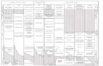
FIGURE 10.--Generalized correlation chart of uppermost Mississippian, Pennsylvanian, and Lower Permian
stratigraphic units in Kentucky and adjacent States.
[Click on image to open a larger version in a new window.] |
Caseyville Formation (Pca).--The Caseyville Formation was named for exposures of massive cliff-forming, crossbedded, pebbly sandstone on the Ohio River near Caseyville, just north of the mouth of the Tradewater River (Owen, 1856). At the type locality, the Caseyville is a channel deposit that occupies the broad Evansville paleovalley of Potter and Desborough (1965). The valley, which is as much as 15 mi wide and 250 ft deep, has been traced in the subsurface by Bristol and Howard (1971, fig. 4) for about 130 mi across Kentucky and Indiana. At the type section, about 10 mi northwest of Caseyville, Lee (1916) described the Caseyville as a formation about 500 ft thick that includes pebbly quartzose sandstone, carbonaceous and calcareous shale, limestone, and coal. Lee placed the top of the Caseyville at the top of a massive pebbly to conglomeratic sandstone that is about 80 ft thick.
None of the sandstone units of the Caseyville Formation are persistent: some sandstone units are terminated at the walls of the paleovalleys, and others pinch out or grade into siltstone (Potter and Desborough, 1965, fig. 6). As a result, the Caseyville varies greatly in thickness and lithology from place to place. Thus, the top of the Caseyville is mapped locally in the western part of the western Kentucky coal field at the base of the Bell (or No. lb) coal bed because that coal is in places only a few tens of feet above pebbly Caseyville sandstone, but in most other parts of the basin where the Bell coal bed does not persist or cannot be identified owing to poor exposures, the Caseyville has been combined on the quadrangle maps with the overlying Tradewater Formation. On the State geologic map, the contact at the top of the Caseyville in most areas of the western Kentucky coal field is approximately located by projection of the horizon of the Bell coal bed from overlying and underlying units, such as the Lead Creek or Curlew Limestone Members of the Tradewater Formation or the top of the Mississippian, all of which were identified in drill hole logs by T.M. Kehn and J.G. Beard.
Tradewater Formation (Pt).--The Tradewater Formation was named by Glenn (1912, p. 74) for exposures along the Tradewater River in Kentucky. The formation is about 600 ft thick and extends from the top of a pebbly quartzose sandstone in the Caseyville Formation or from the base of the Bell (No. lb) coal bed to the base of the No. 6 (Davis) coal bed. The formation is composed of about equal amounts of sandstone, siltstone, and shale and contains several beds of limestone as well as several economic coal beds.
According to Siever (1957, p. 235), the sandstone units of the lower part of the Tradewater (below the Curlew Limestone Member) represent a transitional facies between the mineralogically mature orthoquartzites of the Caseyville Formation and the clearly immature subgraywackes that occur throughout the Pennsylvanian section above the Curlew Limestone. Furthermore, these sandstones are finer grained and tend to be more sheetlike in shape than the channel-fill linear deposits of the coarser grained Caseyville sandstone.
The Tradewater contains three beds of limestone that are of stratigraphic significance to regional and interregional correlations: the Lead Creek Limestone Member, the Curlew Limestone Member, and the Yeargins limestone member of Douglass (1979). Of these, only the Curlew is shown on the stratigraphic column for western Kentucky (sheet 1). The Curlew, like the other limestones, is light to medium gray, dense, and thin to thick bedded and contains abundant crinoid plates, bryozoans, corals, and fusulinids. It is the most extensive stratigraphic marker within the Tradewater Formation.
The Lead Creek Limestone Member occurs about 100 ft above the No. 3 coal bed and has been mapped in
quadrangles mostly in the eastern and northeastern parts of the western Kentucky coal field. Stratigraphic
investigations since completion of the mapping project have identified the Lead Creek in the subsurface in
other parts of the coal field, suggesting that it is an important marker in the lower part of the Pennsylvanian
sections (Williams and others, 1982). The limestone contains Profusulinella kentuckyensis (Douglass, 1979), the
most primitive of the fusiform fusulinids yet identified in North America. The Yeargins limestone member
commonly underlies the No. 6 coal bed and contains fusulinids similar to those found in the Vanport
Limestone Member of the Allegheny Formation in Ohio.
On some quadrangle maps, the No. 6 coal bed was not identified by name or was too thin to map; on
others, the No. 6 was identified by local names. In both these cases the contact between the Tradewater and
overlying Carbondale Formation was compiled for the State map by T.M. Kehn and J.G. Beard, who
extended the position of the No. 6 coal bed throughout the western Kentucky coal field.
Carbondale Formation (Pc).--As originally defined in the area of Carbondale, Ill., by Shaw and Savage (1912), the Carbondale Formation included strata from the bottom of the Murphysboro coal bed to the top of the Herrin coal bed. Lee (1916, p. 30) adopted this definition for his work in Kentucky but used the local Kentucky coal bed names, the No. 6 (Davis) coal bed for Murphysboro and the No. 11 coal bed for Herrin. This usage was retained by the U.S. Geological Survey on all quadrangle maps for western Kentucky and on the State geologic map.
In Illinois, the Carbondale Formation has been redefined several times since it was first described. These redefinitions include those by Weller (1940), who raised the Carbondale to a group, and by Willman and Payne (1942), who moved the boundaries of the formation to the bases of prominent sandstone units. Kosanke and others (1960) again redefined the Carbondale in Illinois to include strata between the base of the Colchester (No. 2) coal bed (the No. 8 coal bed of Kentucky usage) and the top of the Danville (No. 7) coal bed (which is probably younger than the No. 14 coal bed of Kentucky; see fig. 10). None of these redefinitions have been accepted for use in Kentucky by either the U.S. Geological Survey or the Kentucky Geological Survey.
The Carbondale Formation is locally more than 400 ft thick in Kentucky and consists of siltstone, shale, and some locally prominent sandstone units. The formation contains many thin but extensive unnamed argillaceous limestone beds as well as many of the thicker and more economic coal beds of the western Kentucky coal field. The No. 11 coal bed at the top of the formation contains a distinctive clay shale parting and can be traced throughout the Eastern Interior basin. The parting, 2 to 4 in thick, is commonly light bluish gray and is referred to as the "blue band." It has a pelletal or grainy structure similar to some flint clays that are alteration products of volcanic ash falls. The No. I 1 coal bed is the most useful stratigraphic marker in the western Kentucky coal field and is an important datum for subsurface resource studies.
Sturgis Formation (PPs).-The Sturgis Formation was named for Sturgis, Ky. (Kehn, 1973). Because the rocks are generally poorly exposed in that area and no outcrop was adequate, the type section was designated as a composite section of two core holes and a stratigraphic test hole drilled in an area 5 to 8 mi northeast of Sturgis (Kehn, 1973, figs. 3, 4). As defined, the Sturgis Formation comprises all of the strata that had been previously assigned to the Lisman and Henshaw Formations, which were abandoned. In the type area, the Sturgis Formation was reported to be as much as 2,650 ft thick. However, in a later modification of the formation, Kehn and others (1982) restricted the Sturgis to a stratigraphic thickness of 2,039 ft between the top of the No. 11 coal bed and the base of a limestone and calcareous siltstone sequence, which they assigned to the newly defined Mauzy Formation.
The Sturgis Formation is composed of interbedded sandstone, siltstone, shale, limestone, and coal. Sandstone is the dominant rock type and makes up about 40 percent of the formation. Sandstone is commonly fine to medium grained, but locally some units such as the Anvil Rock Sandstone Member are in part coarse grained and contain a few quartz pebbles. The Anvil Rock Sandstone Member (not shown on the stratigraphic column of western Kentucky, sheet 1), which is as much as 110 ft thick, occurs near the base of the Sturgis Formation and locally disconformably overlies the No. 11 coal bed or other parts of the Carbondale Formation. The Dixon sandstone of Glenn (1912) occurs in the middle of the Sturgis Formation and is rarely more than 25 ft thick; it is not persistent and has not generally been traced by other geologists.
Limestone, which makes up less than 5 percent of the Sturgis Formation, is more abundant in the Sturgis than in the underlying Carbondale Formation. It occurs in beds that range from a fraction of an inch to as much as 10 ft thick. Many of the thicker limestones contain abundant brachiopods, crinoid fragments, and fusulinids as well as other fossils. Several widespread marine limestones are important regional and interbasinal marker beds. Among these are the Providence Limestone Member, the Madisonville Limestone Member, and the Carthage Limestone Member. The Providence Limestone Member consists of as many as four limestone beds in a section as much as 33 ft thick. It occurs at the base of the Sturgis Formation and commonly directly overlies the No. 11 coal bed. The Madisonville Limestone Member as described by Kehn (1973, P. B10) in the type area near Madisonville, Ky., also consists of four limestone beds in a 50-ft section; it occurs about 200 ft above the base of the Sturgis Formation. The Providence and the Madisonville are relatively widespread in parts of the Eastern Interior basin and have correlatives in other parts of the basin (Kosanke and others, 1960); they are not known to have correlatives in the Appalachian basin.
The Carthage Limestone Member is locally as much as 10 ft thick and occurs about 465 ft above the base of the Sturgis Formation. It is tentatively correlated with the Livingston Limestone Member of the Bond Formation in Illinois and the Cambridge Limestone Bed of the Conemaugh Formation in Ohio on the basis of fusulinids (Douglass, 1979).
Coal is generally a minor constituent of the Sturgis Formation. Most coal beds are less than 2 ft thick, but the Nos. 12, 13, and 14 coal beds are locally very thick; the No. 14 coal bed is reported to be more than 12 ft thick in some drill-hole logs (Kehn, 1973).
Mauzy Formation.--The Mauzy Formation consists of at least 390 ft of strata previously assigned to, and mapped as part of, the Sturgis Formation (Kehn and others, 1982). The Mauzy Formation is not shown on the geologic map; strata now designated as the Mauzy Formation are shown on the columnar section of western Kentucky (sheet 1) as uppermost Sturgis Formation of Early Permian age. These beds are described in the section on Permian rocks.
In a summary of Pennsylvanian age designations used on the State geologic map, Rice (1978) showed that two different time divisions have been used to characterize the Pennsylvanian rocks of Kentucky. Early, Middle, and Late Pennsylvanian Series are commonly applied to Pennsylvanian strata in the Appalachian basin, whereas the Midcontinent provincial series of Morrowan, Atokan, Des Moinesian, Missourian, and Virgilian are commonly used in the Eastern Interior basin (fig. 10). Correlation between the two is difficult because the Midcontinent series are largely marine and are characterized mainly by marine fossils, while the Appalachian basin series are largely continental and are characterized mainly by plant fossils.
In the early 1960's when the cooperative mapping project began, most geologists incorrectly equated the Morrowan Series with the Early Pennsylvanian Series (see Read and Mamay, 1964, p. K8). By tradition, the Early Pennsylvanian Series comprised the conglomeratic orthoquartzose sandstone sequences of the New River Formation of West Virginia and the Lee Formation of Virginia and Kentucky, which occur in the basal part of the Pennsylvanian section. Thus, in eastern Kentucky the Early/Middle Pennsylvanian boundary was initially placed at the top of the Corbin Sandstone Member, the uppermost sandstone unit of the Lee Formation (Puffett, 1963). The similarity of stratigraphic position and lithology of the Lee of eastern Kentucky and the conglomerates of the Caseyville Formation of western Kentucky led to the projection of the Early/Middle Pennsylvanian boundary to the top of the Caseyville; all USGS quadrangle maps of areas in western Kentucky show the boundary in that position.
In eastern Kentucky, Wanless (1946) and Englund (1962) showed that the Lee Formation intertongues with the overlying Breathitt Formation and that the top of the Lee rises stratigraphically several hundred feet to the northwest. Thus, the Lee in southeastern Kentucky is shown on figure 10 locally to contain Middle Pennsylvanian Strata. Furthermore, both physical stratigraphy and paleontological evidence show that the Corbin Sandstone Member of the Lee Formation is wholly Middle Pennsylvanian in age (fig. 10) (Rice, 1978).
Paleontological data useful in establishing the position of the boundary between the Early and Middle Pennsylvanian Series in areas other than that of the proposed Pennsylvanian stratotype in West Virginia (Englund and others, 1979) are sparse. However, R.M. Kosanke (oral commun., 1978) suggested that the acme of the spore Schulzopora rara of Mississippian to Middle Pennsylvanian age occurs at about the Early/Middle Pennsylvanian boundary in West Virginia, Virginia, and eastern Kentucky, and at about the position of the Battery Rock coal bed in the Caseyville Formation of western Kentucky. Additionally, Kosanke demonstrated that the top of the range zone of that spore occurs in strata as much as 260 ft above the Lee Formation in the Cumberland overthrust sheet, near the base of the Corbin Sandstone Member along the Pottsville Escarpment, and in the upper part of the Caseyville Formation in western Kentucky. These conclusions are largely confirmed by R.A. Peppers (Illinois State Geological Survey, written commun., 1982), who reports rare Schulzopora rara spores in the Reynoldsburg coal bed of southeastern Illinois just above the top of the Caseyville Formation; he suggests that the Early/Middle Pennsylvanian boundary be placed at the top of the Battery Rock Sandstone Member of the Caseyville Formation which underlies the Gentry (Battery Rock) coal bed. Precise correlation of the Battery Rock and the Reynoldsburg coal beds is difficult because they are lenticular, commonly thin, and not persistent. The paleontological data, thus, suggest that the Caseyville Formation is Early and Middle Pennsylvanian in age. A queried boundary for the top of the Lower Pennsylvanian is placed at about the position of the Battery Rock coal bed on the stratigraphic column of western Kentucky (sheet I of the geologic map) and in the explanation.
Although the boundary between the Middle and Upper Pennsylvanian Series was placed at the top of the No. 11 coal bed on most quadrangle maps of western Kentucky, paleontological investigations by Kosanke (1973) and Douglass (1979) suggest that the boundary is probably in the middle of the Sturgis Formation between the Carthage Limestone and the Madisonville Limestone Members. Accordingly, a queried boundary is shown between the No. 15 and No. 16 coal beds in the stratigraphic column on sheet 1.
Provincial series of the Pennsylvanian are not shown on the geologic map, but recent studies have
established a basis for their assignment (fig. 10). Following studies of Furnish and Knapp (1966), who
reported late Morrowan ammonoids from the Kendrick Shale Member of the Breathitt Formation, the
boundary between the Morrowan and Atokan Series in eastern Kentucky is tentatively placed between the
Kendrick and the younger Magoffin Member of the Breathitt Formation, which is Atokan in age (Mackenzie
Gordon, Jr., USGS, written commun., 1976). Thus, the Morrowan-Atokan boundary is as much as 2,000 ft
above the top of Lee Formation in easternmost Kentucky. In western Kentucky, Rice, Kehn, and Douglass
(1979) placed the Morrowan-Atokan boundary in the lower part of the Tradewater Formation below the
Lead Creek Limestone Member, which contains fusulinids of earliest Atokan age. The Morrowan section in
eastern Kentucky contains far more marine units than that section in western Kentucky. This suggests that
marine incursions into the Appalachian basin during Morrowan time were the result of subsidence along
the axis of the Appalachian basin, which provided a periodic avenue for marine transgressions from the
southwest.
Figure 10 shows the salient age relationships of Pennsylvanian units in Kentucky and surrounding States.
The figure is based mainly on the physical stratigraphy established during the cooperative mapping project
and on investigations of plant spores by R.M. Kosanke, a reexamination of fusulinids from Pennsylvanian
and Permian limestones in Ohio, Illinois, and Kentucky by R.C. Douglass, and identifications of ammonoids
and other fossils by Mackenzie Gordon, Jr. The character of the Pennsylvanian strata in the two coal fields of
Kentucky and surrounding States is so varied that it is not possible here to show all the elements that make
up that section. The correlation chart on sheet 3 of the geologic map gives some idea of the detail necessary
to account for known strata in one basin-and even that is a generalization that will probably undergo some
revisions as more subsurface data for coal beds in the lower part of the section become available.
NEXT || PREVIOUS || Return to STRATIGRAPHY