
CONTRIBUTIONS TO THE GEOLOGY OF KENTUCKY
The igneous intrusives are of two types: lamprophyre and peridotite dikes and sills in Caldwell, Crittenden, and Livingston Counties of the western Kentucky fluorspar district and three small peridotite intrusions in Elliott County, northeastern Kentucky (fig. 11). Both types are considered Early Permian in age on the basis of K-Ar and Rb-Sr dating of biotite (Zartman and others, 1967). They constitute the only outcropping igneous rocks in Kentucky.
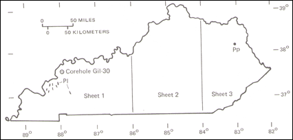
FIGURE 11.--Area of outcrop of Permian intrusive rocks in Kentucky. Pl, lamprophyre dikes; Pp, Elliott County peridotite bodies. Corehole Gil-30 is the type locality of the Mauzy Formation. |
The lamprophyre and peridotite dikes and sills (PI) in the western Kentucky fluorspar district, which are discussed in a summary report by Trace and Amos (1984), are shown on seven geological quadrangle maps (table 1). A total of 39 separate bodies are shown on these maps, and most of these are included on the State geologic map (sheet 1) as red lines or outcrop symbols. Most of the bodies (24) are located in the Salem quadrangle; a few are mapped on the basis of drill data (Cave In Rock and Lola quadrangles). The dikes and sills range in length from a few yards to as much as 3.5 mi, if the two outcrops labeled "Hobby dike" in the Crider quadrangle are a single continuous dike, and range in thickness from a few inches to as much as 75 ft (Warren, 1956). Most strike northwesterly or northerly. The dikes are typically dark gray to dark greenish gray, fine to medium grained, and slightly porphyritic; they are composed of biotite, serpentine, chlorite, phlogopite, olivine, pyroxene, calcite, dolomite, and a number of opaque accessory minerals (Trace and Amos, 1984, p. 29). The rock is generally highly weathered.
TABLE 1.--Geologic quadrangle maps containing lamprophyre and peridotite dikes and sills
Quadrangle and GQ No. | Reference | Number of bodies shown |
| Burna 1150 | Amos (1974) | 2 |
| Cave In Rock 1201 | Trace(1974b) | 4 |
| Crider 1283 | Rogers and Trace (1976) | 2 |
| Lola 1288 | Trace (1976) | 2 |
| Marion 547 | Trace (1966) | 3 |
| Salem 206 | Trace(1962) | 24 |
| Smithland 657 | Amos (1967) | 2 |
The Early Permian age of strata previously assigned to the Pennsylvanian was indicated by the discovery, after completion of the mapping project, of a few large specimens of the fusulinid Triticites sp. in a Kentucky Geological Survey core hole in western Kentucky (Douglass, 1979). These strata, shown as the uppermost part of the Sturgis Formation of Early Permian age on the columnar section for western Kentucky (sheet 1), have been renamed the Mauzy Formation by Kehn and others (1982), on whom the following discussion is largely based. The rocks of the Mauzy Formation are largely covered by loess and alluvium, so the type section is from the corehole, Gil-30 (see fig. 11), which is on file in the well sample and core library of the Kentucky Geological Survey.
The Mauzy occurs in a single small fault block in the Rough Creek fault system. The nearest sediments of Permian age are nonmarine shales and sandstones of the Dunkard Group in the Appalachian basin of Pennsylvania, Ohio, and West Virginia; these outcrops lie some 300 mi east of the Mauzy.
The Mauzy Formation is composed of interbedded shale, siltstone, limestone, and sandstone. Shale and siltstone, the dominant rock types, are generally calcareous and range from gray to black or green. Limestone, which constitutes about 25 percent of the formation, is generally fine grained, even bedded in beds as much as 10 ft thick, and argillaceous. The Mauzy is apparently gradational with the underlying Sturgis Formation. The base of the formation is placed at the base of a limestone sequence 390 ft below the top of the type section and separates a more calcareous section above from a more sandy and coaly section below. The top of the formation is missing owing to erosion at the type section; the thickness elsewhere in the fault block is not known. Kehn and others (1982, p. 78) estimate on the basis of structural projections that the Mauzy may be as much as 1,300 ft thick.
The lower boundary of the Permian System cannot be precisely located. Kehn and others (1982, p. 79) arbitrarily place the boundary at the base of the Mauzy Formation, 200 ft above the Sulphur Springs coal bed of Late Pennsylvanian age and 140 ft below the Early Permian fusulinids reported in corehole Gil-30.
NEXT || PREVIOUS || Return to STRATIGRAPHY