Skip Links

USGS - science for a changing world

Professional Paper 1386–A

Chapter A–4 (Figure 26)

Return to Home

Return to figure gallery

Select image for high resolution and Save to download
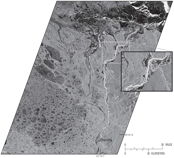
Figure 26, European Remote Sensing Satellite-1 (ERS-1) synthetic aperture radar(SAR) image of the Kolyma River, Russia, on 12 October 1993 showing an icebreaker track in the ice between the Arctic Ocean and the city of Cherskiy (lat 68.8°N., long 161.3°E.), a straight line distance of 100 km. The insert (center right) shows an enlarged section of the river and the icebreaker track. To the west of the river lies the Kolyma Lowland and many tundra lakes covered with new ice. The full image covers an area of 100 km by 140 km on the ground. The insert covers an area of 18 km by 24 km on the ground.

Figure 26. European Remote Sensing Satellite-1 (ERS-1) synthetic aperture radar (SAR) image of the Kolyma River, Russia, on 12 October 1993 showing an icebreaker track in the ice between the Arctic Ocean and the city of Cherskiy (lat 68.8°N., long 161.3°E.), a straight line distance of 100 km. The insert (center right) shows an enlarged section of the river and the icebreaker track. To the west of the river lies the Kolyma Lowland and many tundra lakes covered with new ice. The full image covers an area of 100 km by 140 km on the ground. The insert covers an area of 18 km by 24 km on the ground.


Accessibility FOIA Privacy Policies and Notices

Take Pride in America logo USA.gov logo U.S. Department of the Interior | U.S. Geological Survey
URL: http://pubsdata.usgs.gov/pubs/pp/p1386a/gallery4-fig26.html
Page Contact Information: GS Pubs Web Contact
Page Last Modified: Thursday, 01-Dec-2016 16:25:55 EST