First reports about glaciers in Bolivia are available from the last century (d'Orbigny, 1835-1847). Although no records by the native Indian population exist, the mountain land up to the glacier tongues has been used for many centuries for cattle and by vicuñas, llamas, and alpacas. The lack of records stems primarily from the fact that the Indian population had no writing system. Their verbal history of the glaciers and mountain peaks was based on myths. For the Indians, the glaciers and mountain peaks are inviolably divine.
At the beginning of the 20th century, a wave of glacier exploration took place. It was a time devoted to eliminating blank places on maps of the Earth. This period also produced the first sketches and maps of Bolivia's glacierized mountains. In terms of scientific content, the research was directed at snowline and glacier terminus locations and glacier morphology and distribution. Names such as Conway (1900), Hauthal (1911), and Herzog (1913, 1915) bear witness to this period of research activity. During this period and immediately following, a variety of mountain-climbing expeditions often included scientists. Most successful with respect to cartography and glacier exploration was that of the German-Austrian Alpine Association expedition in 1927-28 led by Carl Troll. His precise field photographs and triangulation measurements formed the basis for a number of good route drawings. He produced accurate general maps and a precise topographic map of the northern Cordillera Real (Illampu area) (Troll and Finsterwalder, 1935) at a scale of 1:50,000, which was based on terrestrial photogrammetric methods. Their precision and cartographic perfection were never equaled by any other map of glacierized regions in Bolivia. A period of relative quiet followed this high point of cartographic-glacier exploration and research at the end of the 1920's, but later alpine expeditions produced route drawings. Geological studies in the high mining regions of the Cordillera Tres Cruces by Federico Ahlfeld resulted in a general map of this massif (Ahlfeld, 1946), which sketches the general distribution of glaciers. A recent topographic map of the Illampu area has been made by using aerial photos taken in 1963 and 1975 (Finsterwalder, 1987). Because of the accuracy of Troll and Finsterwalder's 1935 topographic map, it has been possible to quantify the ice loss by comparing that map with Finsterwalder's 1987 map. An accurate cartographic map of the southern Cordillera Real (Illimani area) has also been published at a scale of 1:50,000 (Finsterwalder, 1990; Jordan and Finsterwalder, 1992).
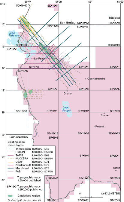
Official mapping of Bolivia was started in the 1940's with assistance from the U.S. Army Map Service. The work was based on vertical aerial photographs and is being completed and updated by the Instituto Geográfico Militar (IGM) in La Paz. The maps have scales of 1:50,000 and 1:250,000 (fig. 16). To date, only part of the glacierized regions in the environs of La Paz and the Cordillera Occidental has been covered by published maps. Unfortunately, no distinction is made between snow patches and glaciers on these maps. Thus, the maps show the snow cover prevailing at the time that the vertical aerial photograph was made and do not show the actual glacier distribution. Although the snow patches and glaciers on these maps are depicted by blue contour lines, they are nonetheless unsuitable for glacier studies. It is almost always necessary to analyze the vertical aerial photographs.
Figure 16.--Aerial photographs and topographic maps of the glacierized regions of Bolivia. The photograph and map summary shows the status of photogrammetric flights having scales from 1:30,000 to 1:50,000, and the published topographic maps having scales of 1:50,000 and 1:250,000. In order to keep the index legible, only the photographic flights that record Holocene glaciers are plotted.
Later, a survey of the glaciers of Bolivia was conducted by Mercer (1967). Since 1975, the author has carried out modern glaciological and glacial-hydrologic studies in Bolivia by using mass-balance data and energy records; his studies include measurements of ice movement, precipitation, temperature, evaporation, ablation, and glacier runoff. He has taken terrestrial photogrammetric photographs of reference glaciers and has surveyed the location of glacier termini. He also has undertaken the compilation of a glacier inventory for Bolivia (Jordan and others, 1980). For this purpose, aerotriangulations of Bolivia's glacierized regions, which up to now had not been recorded on official maps, were carried out from the northern Cordillera Real across the Cordillera Apolobamba to the Peruvian border. This work has been published in two volumes (text and maps and illustrations) and contains the maps of all glacierized areas of Bolivia (Jordan, 1991; Herrmann, 1993). The data are also part of the "World Glacier Inventory" of the United Nations Environment Programme/United Nations Educational, Scientific, and Cultural Organization/International Commission on Snow and Ice (UNEP/UNESCO/ICSI) [now part of the World Glacier Monitoring Service, Zürich, Switzerland].
| Home | Next |
U.S. Geological Survey, U.S.Department of the Interior