As shown in figure 2 of the "Glaciers of the Dry Andes," the elevation of the main mountain range that forms the water divide is much lower south of lat 35°S. than in the Central Andes (lat 31°S. to lat 35°S.). Thus, in spite of the existence of cirque basins, no cirque glaciers are present until one reaches the vicinity of Lago Nahuel Huapí (lat 41°S.).
On the west side of the main range dominating the Chilean Central Valley and the sea of Chiloé, an extensive string of 37 volcanoes has sufficient elevation to rise above the equilibrium line for glaciers. These volcanoes are listed in table 9. The total area of glaciers, according to an unpublished inventory by Gino Casassa, is 267 km2. Almost no glaciological observations have been made on these ice-capped volcanoes because scientific interest in them is minimal. The main utility of satellite imagery in this area is to analyze any changes that follow effusive or explosive volcanic eruptions (González-Ferrán, 1995). A preliminary inventory of the glaciers and snowfields in the Argentine Andes between lat 39° and 42°20'S. was published by Rabassa (1981). A review of the inventories of the glaciers of Chile was done by Casassa (1995).
Table 9.--Ice-capped volcanoes south of lat 35°S., Chile and Argentina
[Slash (/) indicates a place-name variation between Argentina and Chile (for example, Monte/Cerro Tronador: Argentina, Monte Tronador; Chile, Cerro Tronador). Elevations from Carta Nacional de Chile (CNC), 1945 edition, unless otherwise indicated; CP, Carta Prelíminar, which became a U.S. Air Force Operational Navigation Chart (ONC) after reduction; C.A.B., Club Andino Bariloche. Information on eruptive history from "Volcanoes of the World" (Simkin and Siebert, 1994) and "Global Volcanism 1975-1985" (McClelland and others, 1989); additional information from Andrés Rivera; n.d., no data available. ** indicates that the volcano is not listed in either volume]
|
Volcano (alternate name) Argentina/Chile |
Country |
Elevation |
Latitude |
Longitude |
Landsat |
Number of and last |
Remarks |
|---|---|---|---|---|---|---|---|
|
Cerro del Planchón/Volcán El Planchon |
Argentina, |
3,891 |
35°15' |
70°34' |
249-84, |
n.d. |
|
|
Volcán Peteroa |
Argentina, |
3,951 |
35°17' |
70°34' |
249-84, |
13 in 1991 |
|
|
Volcán Descabezado Chico |
Chile |
3,250 |
35°31' |
70°37' |
249-85 |
n.d. |
|
|
Volcán Descabezado Grande |
Chile |
3,880 |
35°33' |
70°45' |
249-85 |
1 in 1932 |
CP: 3,830 m |
|
Volcán Quizapu |
Chile |
3,810 |
35°35' |
70°45' |
249-85 |
13 in 1967 |
CP: 3,050 m (after explosion that covered entire region with white tephra) |
|
Cerro Campanario |
Argentina, |
4,002 |
35°55' |
70°22' |
249-85 |
** |
|
|
Volcán San Pedro=Las Yeguas |
Chile |
3,500 |
35°59' |
70°51' |
249-85 |
** |
CP: 3,499 m |
|
Cerro Lástimas |
Chile |
3,050 |
35°59' |
71°08' |
249-85 |
** |
|
|
Nevado Longaví |
Chile |
3,230 |
36°12' |
71°10' |
249-85 |
** |
CP: Nevado de Lonquen |
|
Volcán Domuyo |
Argentina |
4,709 |
36°38' |
70°26' |
249-85 |
** |
CP: 4,785 m |
|
Nevados de Chillán |
Chile |
3,180 |
36°50' |
71°25' |
249-86 |
17 in 1987 |
CP: 3,169 m |
|
Volcán Antuco |
Chile |
2,985 |
37°24' |
71°22' |
249-86 |
12 in 1972 |
|
|
Sierra Velluda |
Chile |
3,585 |
37°28' |
71°26' |
249-86 |
** |
CP: 3,385 m |
|
Volcán Copahue |
Argentina, |
3,010 |
37°51' |
71°10' |
249-86 |
2 in 1992 |
CP: 2,969 m |
|
Volcán Callaquén (Callaqui) |
Chile |
3,164 |
37°55' |
71°25' |
249-86 |
2 in 1980 |
|
|
Volcán Tolhuaca |
Chile |
2,780 |
38°18' |
71°39' |
249-87 |
** |
CP: 3,780 m (misprint) |
|
Volcán Lonquimay |
Chile |
2,822 |
38°22' |
71°35' |
249-87 |
4 in 1989 |
Place-name misplaced on ONC R-23 |
|
Cordillera Blanca |
Chile |
2,554 |
38°34' |
71°34' |
249-87 |
** |
CP: Sierra Nevada |
|
Volcán Llaima |
Chile |
3,124 |
38°42' |
71°42' |
249-87 |
36 in 1994 |
|
|
Nevados de Sollipulli |
Chile |
2,326 |
39°00' |
71°34' |
249-87 |
** |
CP: Picos de Llollicupi |
|
Volcán Villarrica |
Chile |
2,840 |
39°25' |
71°57' |
249-87, |
51 in 1985 |
|
|
Volcán Quetrupillán |
Chile |
2,360 |
39°29' |
71°42' |
249-87, 248-88 |
Holocene age |
|
|
Volcán Lanín |
Argentina, |
3,774 |
39°39' |
71°31' |
249-87, |
Holocene age |
|
|
Volcán Shoshuenco (Chos Huenco) |
Chile |
2,430 |
39°56' |
72°02' |
249-88 |
n.d. |
|
|
Cerro (Volcán) Puntiagudo |
Chile |
2,490 |
40°57' |
72°16' |
249-88, 249-89 |
1 in 1930(?) |
|
|
Monte/Cerro Tronador |
Argentina, |
3,470 |
41°09' |
71°55' |
249-89 |
** |
CP: 3,460 m |
|
Volcán Osorno |
Chile |
2,660 |
41°06' |
72°30' |
249-89 |
11 in 1869 |
|
|
Volcán Calbuco |
Chile |
2,015 |
41°19' |
72°36' |
249-89 |
10 in 1972 |
Small glacier on south flank |
|
Monte Yate |
Chile |
2,185 |
41°47' |
72°24' |
249-89 |
** |
|
|
Volcán Minchinmávida |
Chile |
2,470 |
42°47' |
72°26' |
249-90 |
1 in 1835 |
CP: 2,481 m; name and elevation given to a much lower caldera to the west-southwest |
|
Volcán Yelcho |
Chile |
2,020 |
43°09' |
72°34' |
249-90 |
** |
|
|
Volcán Corcovado |
Chile |
2,300 |
43°11' |
72°47' |
249-90 |
2 in 1835 |
ONC S-21 |
|
Cerros (Volcán) Yanteles |
Chile |
2,042 |
43°30' |
72°49' |
249-90 |
Fumarolic (3 |
|
|
Monte Melimoyu |
Chile |
2,400 |
44°05' |
72°52' |
248-91, |
Holocene age |
|
|
Monte Mentolat |
Chile |
1,660 |
44°41' |
73°05' |
248-91, |
n.d. |
|
|
Monte Cay |
Chile |
2,200 |
45°03' |
72°59' |
248-91, |
** |
ONC S-21 |
|
Monte (Volcán) Macá |
Chile |
2,960 |
45°06' |
73°12' |
249-91, |
Holocene age |
Elevation is much less according to Neumeyer (C.A.B., 1954, p. 20) |
|
Volcanoes of the Patagonian Andes |
|||||||
|
Cerro (Volcán) Hudson |
Chile |
~2,500 |
45°55' |
72°57' |
248-92 |
1991 |
Tephra over a wide area in 1971 |
|
Cerro (Volcán) Arenales |
Chile |
3,437 |
47°12' |
73°29' |
248-93 |
1979 |
Landsat image 30368-13444 shows tephra |
|
Cerro Mimosa |
Chile |
~2,000 |
48°57' |
73°32' |
248-94 |
Fumarolic in 1973 |
|
|
Cerro (Volcán) Lautaro |
Chile |
3,380 |
49°02' |
73°33' |
248-94 |
5 in 1979 |
|
|
Cerro Aguilera |
Chile |
2,438 |
50°25' |
73°47' |
248-95 |
Holocene age |
Recognized as a volcano in 1985 |
|
Monte (Volcán) Burney |
Chile |
1,758 |
52°21' |
73°23' |
246-97 |
1910 |
|
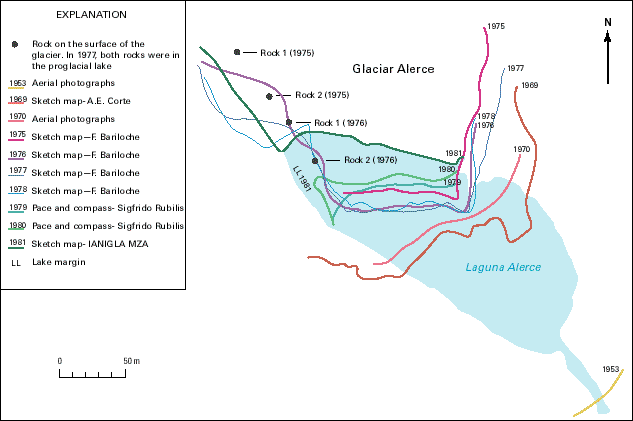
Glaciers of Volcán Lanín (lat 39°40'S.) and Monte/Cerro Tronador (an old, dissected volcano) (lat 41°10'S.) (fig. 21) have been studied by Argentine scientists (Rabassa and others, 1978). In particular, Monte/Cerro Tronador has been mapped several times (fig. 22). The terminus of Glaciar Alerce, the easternmost of its 11 outlet glaciers, has been surveyed repeatedly since 1953; it shows a continuous retreat except for the period 1976-77 (fig. 23). Two of its other outlet glaciers, Glaciar Negro and Glaciar Castaña Overo, have been surveyed since 1970.
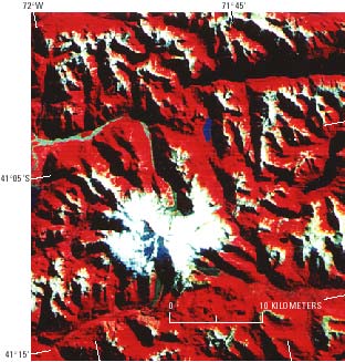
Figure 21.--Section of a Landsat 2 MSS false-color composite image (2436-13433; 2 April 1976; Path 249, Row 89) of Monte/Cerro Tronador, an old, dissected volcano that has an ice cap and 11 outlet glaciers. Landsat image is from the EROS Data Center, Sioux Falls, S. Dak.
Figure 22.--Monte/Cerro Tronador and environs, Chile and Argentina, by Lliboutry (1956). Drawn from the Carta Prelíminar (CP) at a scale of 1:250,000 and from sketch maps published by Club Andino Bariloche. Since the Trimetrogon survey of 1945 (from which the CP was compiled), the east glacier at the head of Río Alerce has receded, and Laguna Alerce has formed (fig. 23). The thick lines are ridge-lines, the hachured lines are cliffs, the short lines on the glacier indicate steepness, and the dotted areas are debris-covered glaciers or rock glaciers. The border between Chile and Argentina follows the ridgelines north from south of Cerro Volcánico to Pico Argentino to west of Laguna Frias. Abbreviations: Co., Cerro; Mo., Montana; P., Pico; Pto., Puerto; L., Lago; R., Río; and Lag., Laguna.
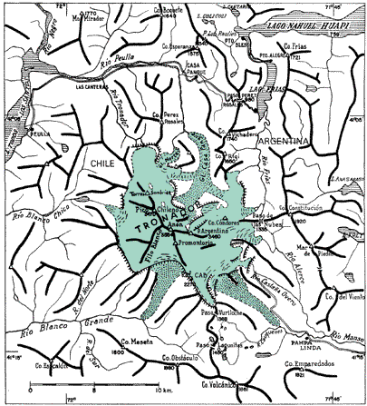
Figure 23.--Fluctuations of the terminus of Glaciar Alerce (east flank of Monte/Cerro Tronador) between 1953 and 1981. Modified from a sketch map compiled by A.E. Corte (Instituto Argentino de Nivología y Glaciología, Mendoza (IANIGLA, MZA)).
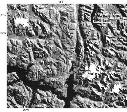
South of Lago Nahuel Huapí (fig. 22), small cirque glaciers appear, and south of Paso Cochamó (lat 41°30'S.), they become ubiquitous (see sketch maps of the area west of Lago Puelo in Lliboutry (1956, p. 346) and of the area west of Lago Menéndez in Juárez and Puente Blanco (1963)). By using Chilean vertical aerial photographs and Landsat images that cover the area (Paths, Rows 249-89, 248-90, 248-91, and 249-91; table 1), a preliminary glacier inventory can be achieved. The first glaciers that are large enough (about 12 km long) to be monitored by satellite imagery are two outlet glaciers that flow from two small ice fields. One, the Queulat ice cap (about 80 km2), is centered at lat 44°25'S., long 72°25'W., and is at an elevation of 1,889 m according to ONC S-21. The other (about 40 km2) is centered at an unnamed summit at lat 44°30'S., long 72°19'W., at an elevation of 2,255 m according to ONC S-21 (fig. 24). This area borders a fjord called Seno Ventisquero (ventisquero is the old Spanish name for glacier).
Figure 24.--Part of a Landsat 2 MSS image (21515-13324, band 7; 17 March 1979; Path 248, Row 91) of the northern Wet Andes showing the volcano Monte Melimoyu in the upper left and two small ice fields that have outlet glaciers in the lower right. Landsat image is from the EROS Data Center, Sioux Falls, S. Dak.
| Home | Next |
U.S. Geological Survey, U.S.Department of the Interior