Climatic conditions generally determine the possibility of glacier development, and different climatic patterns in different areas produce different types of glacier development. The climatic conditions in the Ecuadorean part of the Andes Mountains are highly varied, and the factors that control the weather patterns are not completely understood because of the lack of upper atmosphere observations (see also Hastenrath, 1981, p. 8).
Monthly mean temperatures follow the typical tropical pattern and have very minor fluctuations throughout the year, normally less than 2°C. In contrast, temperature differences between day and night are quite large, and the difference increases with elevation. On Cotopaxi, at an elevation of 3,560 m above sea level (asl), the absolute maximum and minimum daily temperatures are +20.4°C and -4.8°C, respectively. According to Graf (1981, p. 16), the average temperature gradient in the mountain region is about 6.5°C/1,000 m, the 0° annual isotherm being at an elevation of about 4,700 m. The average regional snowline is a little higher, about 4,800-4,900 m, and has a fluctuation of about +-200 m, depending on differing precipitation conditions and slope orientation.
Precipitation conditions in the two areas of the Ecuadorean Andes are influenced by air masses from two different regions. The western Cordillera Occidental gets its moisture from the Pacific Ocean, and the intensity decreases toward the south, as is clearly shown by the general map (fig. 1). The cordillera is characterized by rainy and dry seasons that are accentuated toward the south. Precipitation maximums coincide with the higher positions of the Sun in March and April. The Cordillera Oriental, on the other hand, gets its precipitation from the Amazon basin and has an almost uniform precipitation distribution throughout the year but an increase in amount toward the south (see fig. 2).
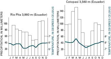
Figure 2.--Average monthly precipitation and temperatures from two meteorological stations near Cotopaxi volcano. Both stations are located south of the Equator and reveal the double precipitation maximum and only minor fluctuations in the average monthly temperatures, which are characteristic of the Andean area. Graphs modified from Blandin Landivar (1976-77).
These two precipitation patterns collide in the Andes Mountains and are considerably influenced by the topographic relief. Whereas the outer crests of the two cordillera ranges are heavily influenced by the adjacent precipitation regions, the inner high-valley region and the mountain slopes adjacent to it are typically characterized by a twin-peak precipitation distribution. This twin-peak distribution reaches its maximum around the times that the Sun is at its highest elevation in March and September and is at a minimum in July and August.
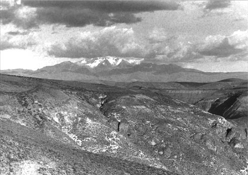
A vertical precipitation differential also exists in Ecuador, in which the maximum precipitation is found at the middle elevations of the western slope of the Cordillera Occidental and the eastern slope of the Cordillera Oriental below an elevation of 2,000 m asl (fig. 1). This phenomenon is known as well from tropical mountains in Colombia (Weischet, 1969) and in Bolivia (Jordan, 1979). Satellite images and weather observations confirm that a second condensation level develops in summit locations above 5,000 m, as shown on the ground photograph of Cayambe (fig. 3). Just exactly how large the total annual precipitation is cannot be documented because of the absence of meteorological measurements on the high peaks. The two highest weather stations in the middle Ecuadorean Andes near Cotopaxi are at 3,860 m and 3,560 m. A meteorological station has been installed at Antisana, but sufficient data are not yet available. The difference in elevation between the meteorological stations and the summits of the high peaks probably means a significant differential in actual precipitation at the higher elevations.
Figure 3.--Cerro Cayambe (5,790 m) and its pronounced afternoon cloud layer above the second condensation level at about 5,000 m. A second, lower cloud layer can also be seen over the eastern slope leading down to the selva (jungle forest). This cloud layer is rather weakly indicated in the right background by cumulus clouds that are just barely protruding beyond the horizon. This secondary cloud level, which is a particularly well-developed phenomenon associated with the highest mountains, contributes greatly to glacier formation because of the greater annual precipitation and the protection that it affords from solar radiation. Photograph by Ekkehard Jordan taken on 3 January 1981 near Huayllabamba, about 40 km west-southwest of Cayambe, at an elevation of about 2,700 m.
The glacierized regions of both cordillera ranges seem to be influenced most heavily by air masses from the Amazon basin to the east; this is indicated by the fact that glacierization is generally stronger on the east sides of the ranges and by the observation of daily cloud movements. The two weather stations near Cotopaxi reveal the characteristic twin-peak annual precipitation curve for the cordillera zone and document the precipitation pattern prevailing throughout the year (fig. 2). This pattern is typical of continental tropical glaciers, which have periodic fluctuations and no pronounced dry season.
This twin-peak precipitation pattern not only influences the development of the glaciers but has an effect on the investigations of glaciers that depend on aerial or satellite surveys. The frequent cloud cover, including its daily periodic (diurnal) development (fig. 4), severely restricts the scheduling of aerial photographic surveys. In addition, the frequent fresh snowfalls make it difficult for a photogrammetrist to plot elevation contours when mapping glaciers from aerial photographs because of the lack of discernible features and the lack of contrast. The most favorable times to look for maximum glacier exposure are in the two drier periods from December to February and from July to early September (see the section on Bolivia in this volume). In spite of the precipitation minimum in July and August, this is not the best time for field research and investigations in the glacierized areas because violent east winds sweep the higher summit regions during these months. The normal presence of maximum glacier exposure at the end of the summer, which is known in areas outside the tropics, does not apply here; instead, the optimum condition depends on accidentally having periods that have few clouds during the timespan mentioned. Therefore, it is also very difficult to find satellite images that are sufficiently free of clouds to be useful in the delineation of the glaciers.
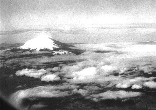
Figure 4.--Oblique aerial photograph of the snow-covered ice cap on Chimborazo (6,310 m) and, in front of it, the snow-covered ice cap of Carihuairazo (5,020 m). As for the other ice-covered peaks of Ecuador's Andes Mountains, these peaks protrude from the broken nighttime cloud cover during the early morning hours and can be seen from a great distance. Shortly after sunrise, they disappear in the rising clouds and, starting in the late morning, they frequently receive precipitation in the form of snow. Photograph by Ekkehard Jordan on 31 May 1977 looking from the northeast at an altitude of about 9,000 m and a distance of about 50 km.
| Home | Next |
U.S. Geological Survey, U.S.Department of the Interior