As one can see in the index map (fig. 1), four of Ecuador's active volcanoes have glacierized peaks: Antisana, Cotopaxi, Sangay, and Tungurahua. The ice-capped volcanoes of the Andes Mountains represent locations in South America where scientists can study the interplay of the exogenous climatic ice with endogenous subglacial geothermal and volcanic activity. A study on the glaciation of Cotopaxi is a good example of this type of work (Jordan, 1983a). Cotopaxi, a stratovolcano, has an elevation of 5,911 m and is one of the Earth's highest active volcanoes. Antisana is a large stratovolcano, 5,753 m high, that last erupted in 1801-02 from the north-northeast side of its summit (Simkin and Siebert, 1994). The interaction of glacial and volcanic processes is quite complex. For example, the rapid compaction of snow in the crater region is caused by a reduction in albedo resulting from very thin tephra blankets on snow. On the other hand, large volumes of ice can be melted by the lava flows and result in devastating lahars 4 (Lipman and Mullineaux, 1981; Jordan and others, 1987). Because of its history of catastrophic eruptions, the Cotopaxi stratovolcano has attained considerable notoriety. Between 1532 and 1942, Cotopaxi had 59 explosive eruptions from its summit crater, including 3 nuées ardentes (a French loanword that refers to a "swiftly flowing, turbulent gaseous cloud, sometimes incandescent, erupted from a volcano and containing ash and other pyroclastics in its lower part" (Bates and Jackson, 1980, p. 479)). Lava flows also accompanied 27 of the eruptions. Fatalities resulted from 5 eruptions, destruction of property took place in 11 instances, and lahars formed in 27 cases (Simkin and Siebert, 1994). The effect of the eruptions on the ice volume becomes more noticeable following recent and (or) frequent eruptions.
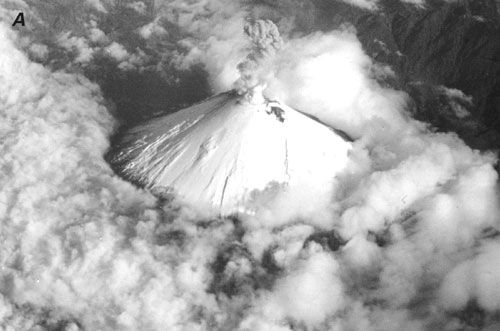
Sangay is also among the Earth's most active volcanoes. Three eruptions were recorded between 1628 and 1934, and a low level of continuous eruption has been noted since then (Simkin and Siebert, 1994). One cannot be certain, however, whether Sangay supports a continuously developed ice cover or only remnants of glacier ice. Several times a year, the alternation of brilliantly shining, fresh snow blankets and earth-colored ash cover can be observed on the peak (fig. 5). The active Tungurahua volcano, which last erupted in 1944, does not possess as much ice cover as the two gigantic volcanoes (Cotopaxi and Sangay) because its summit is only a little bit above the regional snowline.
Figure 5.--The Sangay stratovolcano is one of our planet's most active volcanoes (three eruptions between 1628 and 1934 and in continuous eruption since then) and has a crater that constantly emits fumes. Even though Sangay has a summit elevation of 5,230 m, it protrudes only a little above the snowline. Because of contradictory reports from those who have climbed it, it is not certain even today whether it has only a névé (firn or perennial snow cover) or whether a glacier underlies the névé. Three different stages of snow cover on Sangay are shown in the following illustrations:
A, An oblique aerial photograph shows an almost completely smooth, fresh blanket of snow. The photograph was taken by Ekkehard Jordan from the northwest at an elevation of about 9,000 m on 31 May 1977.
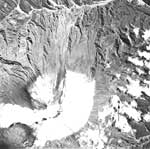
B, A vertical aerial photograph shows the partially destroyed snow cover.
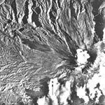
C, A vertical aerial photograph shows the predominantly snow-and-ice free summit region.
No cloud-free Landsat 1, 2 or 3 imagery has been found of Sangay, but Antisana, Cotopaxi, and Tungurahua can be seen. Evidence of active volcanism is particularly evident on a Landsat image of Cotopaxi (fig. 6). On the Landsat image taken on 4 February 1979, it appears as if the crater region has no glaciers and that the western slope is more heavily influenced by volcanism. One can also see that a narrow ice-free area extends along the western slope all the way up to the crater--a phenomenon probably caused by geothermal processes. This phenomenon can also be seen quite well on terrestrial photographs (fig. 7). Figure 8 also clearly shows the asymmetrical distribution of the ice cover on this very uniform, conical stratovolcano. The naturally occurring symmetrical shape of the ice cover that results from climatic effects does not remain constant because of the geothermal activity. Active volcanism, however, is not the only factor affecting the glacier's shape. These small, relatively thin glaciers are also strongly influenced by any type of relief anomaly.
Figure 6.--Segment of a Landsat 2 MSS image enlarged to a scale of 1:250,000 showing the active Cotopaxi stratovolcano (5,911 m) and its pronounced asymmetrical ice cap. It is possible to discern the lack of snow cover along the crater's edge. Cotopaxi is the best example of a glacierized active volcano in the tropics. The strikingly dark-looking ring below the glacier area is caused by the ash cover that is very visible because of the absence of vegetation. The bands thus represent elevation steps on Cotopaxi. The moraine area near the glacier is not identifiable in this image. Landsat MSS image (21474-14323, band 7; 4 February 1979; Path 10, Row 60) from the EROS Data Center, Sioux Falls, S. Dak.
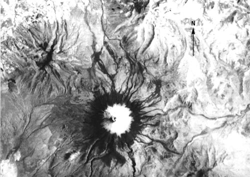
Figure 7.--Glaciers on the west slope of Cotopaxi during a temporary cloud breakup during the afternoon. The highest ice-covered north peak (5,911 m) is visible. The large glacier-free area, extending from the crater's edge in the middle of the picture, is probably due to geothermal activity.
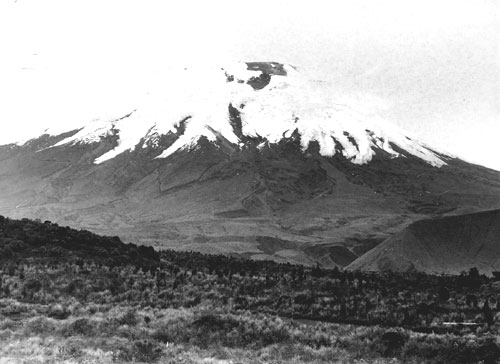
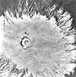
Figure 8.--Vertical aerial photograph of Cotopaxi showing the crater area and most of the summit ice cap.
The best example of a glacier that is affected by relief anomaly in this area is the glacier development on the inactive volcano of Altar, a peak having a steep-walled caldera that is breached toward the west. The prevailing climate conditions normally produce more extensive glaciation along the east slopes. Here, however, the situation is almost exactly the opposite because an extensive glacier snout, which is present on the west slope, is presumably caused by the strong, relief-induced horizontal shading.
A strikingly good delineation of the Ecuadorean tropical glaciers, which even many vertical aerial photographs do not reveal, is shown by two Landsat images taken on 4 and 13 February 1979 (figs. 9, 10). Where image reproduction is good, it is possible to identify the snowline on the glaciers and to determine an approximate separation between the accumulation and ablation areas, something that has not been available for Ecuadorean glaciers. (These features can be seen even better on more recent Landsat Thematic Mapper (TM) and Satellite pour l'Observation de la Terre (SPOT) images and other newer, remotely sensed data that have increased resolution.) These images also make it possible to recognize evidence of Pleistocene glaciation that appears very clearly in many regions, including the mountains near Cotopaxi. It is not possible to see any evidence of Pleistocene glaciation on the active volcanoes Cotopaxi, Sangay, and Tungurahua, however, some former moraine morphology is seen on Antisana.
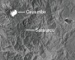
Figure 9.--Landsat 2 MSS image of the northern part of the Ecuadorean Andes showing the glacierized volcanoes discussed in the text.
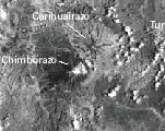
Figure 10.--Landsat 3 MSS image of the southern part of the Ecuadorean Andes showing the area of the glacierized volcanoes and two nonvolcanic mountains discussed in the text.
| Home | Next |
U.S. Geological Survey, U.S.Department of the Interior