
PRE-1980 TEPHRA-FALL DEPOSITS ERUPTED FROM MOUNT ST. HELENS, WASHINGTON
By Donal R. Mullineaux
U. S. Geological Survey Professional Paper 1563
Tephra Set K
Tephra set K consists of a series of at least 10 thin beds of pumiceous
and lithic ash and small lapilli. It commonly forms a relatively obscure gray, stratified band between thick, oxidized
ash-rich deposits east and south of the volcano (fig. 17). No large lapilli or bombs
were found in the set. All its tephra beds are fine grained as well as thin, compared with tephras in the underlying
and overlying sets of Pleistocene age. No distinctive beds were recognized within set K, and no layers or beds
are described individually.
|
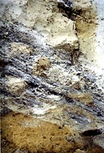
Figure 17. Thin tephras of set K, Mount St. Helens. Dips are primary. Pods of brown ashy material in
the part of the set that is gray and bedded probably are animal-burrow backfills. Pocketknife shown for scale.
Photograph taken in 1979. (113K)
|
A tephra sequence that includes two layers of lapilli, each 30-40 cm thick,
interbedded with several tens of thinner ash beds was observed between sets M and S in a single, disturbed outcrop
8 km northeast of the volcano. Pumice in that sequence is mineralogically similar to that in set K, but the relation
of those strata to the fine-grained set K east and south of the volcano is not known.
Generally, set K strata are partly oxidized and brownish gray, but pumice lapilli
are not weathered enough to be noticeably soft. At least two thin, oxidized zones within the set suggest short
time breaks during its deposition. At most outcrops, the tephras are only patchily preserved (fig.
17); burrowing animals and other near-surface disturbances have almost everywhere strongly affected these thin
deposits.
Set K consists chiefly of finely vesicular pumice along with abundant lithic
fragments. Ferromagnesian mineral suites in pumice of the set consist mostly of cummingtonite and hornblende. Small
amounts of biotite were found, but not consistently, and are not diagnostic of the set. Because its composition
is not distinctive, set K is identified only by its stratigraphic position, characteristic thin beds, and fine
grain size.
Set K is both underlain and overlain near the volcano by 100-200 cm of oxidized,
ash-rich deposits, that generally are as thick or thicker than set K itself. Commonly, both the base and top of
the set are so disturbed that its stratigraphic boundaries are uncertain (fig. 17).
Distribution and thickness
Set K is present fairly consistently from east of the volcano clockwise
to the south, below altitudes of 600 m. In areas 10-15 km east and southeast of the volcano, it commonly is 30-50
cm thick (figs, 18, 19). Sixteen kilometers south of the
volcano, it is almost entirely ash and is about 10 cm thick. The deposits of set K that are preserved probably
do not represent the primary thickness of the set because unknown thicknesses of the tephra have been mixed into
underlying and overlying deposits.
|
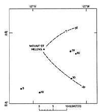
Figure 18. Location and thickness (in centimeters) of tephra in set K. At most outcrops, set K has been
truncated by erosion, and its primary thickness is not known. (8K)
|
Set K was traced only as far as 15-20 km east and south of the volcano.
|

Figure 19. Columnar sections of tephra set K from approximately east to south of Mount St. Helens, and
diagram of their locations relative to the central vent of the volcano. (17K)
|
Pumice lapilli layers and interbedded ash deposits 8 km northeast of the volcano,
which might be correlative with set K, are as thick as 200 cm. The two coarse, thick pumice layers that were observed
there probably extend much farther to the northeast but were not traced or specifically identified elsewhere.
Age
Set K apparently is between about 20,000 and 19,000 years old, based on
carbonized wood recovered from pyroclastic-flow deposits (table 2). South of Mount St.
Helens, sets K and M both overlie a pyroclastic-flow deposit dated at 20,350 ±350 years old (W-2540). Southeast
and south of the volcano, respectively, carbonized wood samples from pyroclastic-flow deposits that overlie set
K have been dated as 19,160 ± 250 (W-4531) and 18,560 ± 180 (W-2413) years old.
Tephra Set S
Set S is characterized by two conspicuous yellow to brown pumice lapilli
and bomb layers that overlie yellowish-gray, finer layers of chiefly ash (figs. 20,
21). In the field, that series of beds of those colors and grain sizes is almost diagnostic
of set S. The two coarse layers at its top dominate the set east of the volcano, but the underlying finer strata
are more widespread and locally are thicker. Pumice in the set is somewhat weathered, in many places enough that
pumice lumps are soft and readily broken or cut. Near the volcano, tephra in the lower and middle parts of the
set typically is interbedded with deposits of ash-cloud or other flowage origin.
|
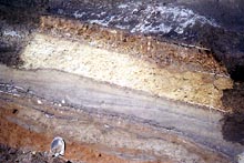
Figure 20. Tephra set S about 7 km east of Mount St. Helens and 100 m above floor of Smith Creek valley.
Thin lenses of grayish-brown ash (at tip of shovel) are the lowest beds of set S here; the overlying ash contains
lenses of probable flowage origin. Layer Sw consists of multiple thin beds of brownish-gray ash containing white
lapilli; it is overlain by crossbedded ash of probable flowage origin. Layer Ss here is a thin, brown ash that
is barely visible under layer Sg. The reddish-brown upper part of layer So was weathered when that layer was exposed
at the surface for more than a thousand years before being buried; pumice lapilli in the upper part of set S are
soft enough to have been cut through during scraping of the outcrop. Shovel blade is about 25 cm long. Photograph
taken in 1979. (194K)
|
In many outcrops near Mount St. Helens, set S is the oldest readily recognizable
tephra set because older sets have been removed or disturbed beyond recognition.
|
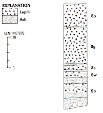
Figure 21. Composite columnar section of tephra set S, Mount St. Helens. (16K)
|
Composition
Dacitic pumice makes up most of set S, especially in the coarser strata.
Ferromagnesian mineral suites consist chiefly of cummingtonite and olive to brownish hornblende. Brown hornblende
makes up as much as half of the hornblende fraction and appears to be more abundant than in sets K and M. Hypersthene
is sparse in layer Sw, in the middle of the set, but makes up several percent of the ferromagnesian mineral fraction
in most other layers.
Chemical analyses of pumice from the base, middle, and top of set S show a range in SiO2 values of about
62-64 percent.
Diagnostic features
Near Mount St. Helens, set S is recognized by its succession of yellow pumiceous
lapilli layers overlying yellowish-gray ash, by its stratigraphic position below the darker brown set J, and ferromagnesian
mineral composition. In outcrop, pumice layers of set S are thicker and have a stronger yellow color than layers
of sets M and K and are lighter in color than layers of set J. Abundance of brown hornblende helps to separate
set S from older cummingtonite-bearing pumices that also contain hypersthene.
Stratigraphic relations
On uplands near the volcano, set S is usually both underlain and overlain
by oxidized, ash-rich deposits that commonly are as thick as 100 cm. Layer So at the top of the set commonly has
been noticeably weathered and disturbed in an oxidized zone. On and near the valley floors, pyroclastic-flow deposits
almost everywhere overlie set S and separate it from set J.
Distribution and thickness
Set S was recognized all around the volcano except directly to the northwest
(figs. 22, 23), and it is thickest, coarsest, and most
complete toward the east-northeast and east. Toward the east, it is commonly 50-70 cm thick at distances of 10-15
km from the volcano. At 10-15 km north and south of the volcano, where only one or two lapilli-bearing beds are
present, the set as a whole generally is only 10-20 cm thick. Toward the southwest and west, it is even thinner,
and only one lapilli-bearing layer was found (fig. 22).
|
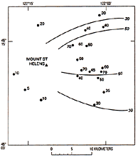
Figure 22. Approximate thickness (in centimeters) of tephra set S at selected locations, Mount St. Helens.
Thickness reported includes only thickness of deposits interpreted as tephra; most stratigraphic sections also
include interbedded deposits of flowage origin. (12K)
|
Downwind, as many as three beds of set S have been identified at multiple sites in eastern Washington as far as
about 300 kilometers from the volcano (Foley, 1976, 1982; Moody, 1977, 1978; Mullineaux and others, 1978; Waitt,
1980; Stradling and Kiver, 1986; Busacca and others, 1992).
Age
Set S apparently was erupted between about 13,600 and 12,500 years ago,
and probably close to about 13,000 years ago. About 50 km northeast of Mount St. Helens, peat from below and above
set S tephra in a bog has been dated at about 13,650 (W-3136) and 12,120 years BP (W-3133) years B.P. (table
2), respectively (Mullineaux and others, 1975; Crandell and others, 1981). On the south flank of the volcano,
a date of about 12,910 years (W-3141, table 2) was obtained for charred wood from a pyroclastic-flow
deposit that underlies one layer of set S tephra there and is compositionally similar to the tephra (fig.
23) (Mullineaux and others, 1975).
Dates of approximately 13,800 and 13,600 years B.P. reported from peat above
beds regarded as set S about 100 km north of Mount St. Helens (Davis and others, 1982; Porter and others, 1983)
conflict slightly with the dates described preceding. That discrepancy may result merely from imprecision of radiocarbon
dating. No radiocarbon date is available, however, for the base of set S at Mount St. Helens, and eruptions that
produced the set may have started before 13,600 years ago.
Description of layers in set S
All the described layers in set S crop out directly east of the volcano,
although the tephra strata in the lower part of the set there are thin and interbedded with thicker ash beds of
probable flowage origin (figs. 20, 23; measured section
S-1). Set S tephras also crop out on the north, west, and south sides of the volcano, but their relation to
layers described east of the volcano is not known, and they were not identified specifically or described separately.
Two thin oxidization zones in the lower part of set S were found at a few outcrops.
These may represent surface oxidation and record brief weathering periods between eruptions, or they may represent
only staining by oxidized material deposited from ground water.
Measured section S-1.
Road cut along pre-1980 logging road 140 on west wall of Smith Creek valley north of Ape Canyon Creek, about 100
m above valley floor; 7 km east of Mount St. Helens. See figure 20.
| |
|
Thickness
(centimeters) |
| 17. |
Pyroclastic-flow deposit, lithic |
60-100 |
| |
Set S and unidentified deposits of similar age |
|
| 16. |
Pumiceous ash and small lapilli, locally crudely layered: contains small amounts of organic material; may be reworked
from layer So |
2-5 |
| 15. |
Layer So. Chiefly brown pumice lapilli; scattered small bombs and lithic fragments; upper half more oxidized than
lower half |
25 |
| 14. |
Ash, pumiceous, brown |
1-2 |
| 13. |
Layer Sg. Pumice lapilli, yellow-brown, normally graded, and small bombs; contains small proportion of lithic fragments |
35-40 |
| 12. |
Ash, fine, grayish-brown |
2 |
| 11. |
Layer Ss. Ash, pumiceous, brown; contains scattered small to large pumice lapilli |
3 |
| 10. |
Ash, fine, brown to gray: contains lenses of coarse ash and small lapilli; crossbedded, probably of flowage origin |
20-30 |
| 9. |
Layer Sw. |
|
| |
Ash, coarse; contains small, white pumice lapilli
|
2-3 |
| |
Ash, fine, gray to grayish-brown
|
1 |
| |
Ash, coarse, gray; contains small, white pumice lapilli |
2 |
| 8. |
Ash, grayish brown; coarser and darker near base; contains scattered pumice lapilli |
2-4 |
| 7. |
Ash, fine, brown to gray, laminated; streaked with iron oxide |
2-4 |
| 6. |
Ash, coarse, and small yellowish-brown pumice lapilli; lenticular |
3 |
| 5. |
Ash, fine, gray to brown |
2-4 |
| 4. |
Ash, lithic, coarse, dark gray; lenticular |
1-4 |
| 3. |
Ash, gray-brown to brown, locally wavy bedded |
15-20 |
| 2. |
Ash, coarse to fine, gray, bedded; lenticular |
0-5 |
| |
Below deposits of set S age |
|
| 1. |
Ash-rich deposit, oxidized, brown; contains some pumice lapilli |
50 |
Layer Sb
The oldest identified tephra in this set, layer Sb, is defined to include
several lapilli-bearing tephra beds below the distinctive gray layer Sw. Locally, layer Sb consists of at least
four thin, yellowish-brown beds of small pumice lapilli in ash. Layer Sb is relatively poorly defined; its beds
are less continuous and more disturbed than other tephras of the set and commonly are intimately associated with
ash of flowage origin. Consequently, it is commonly unclear which strata below layer Sw are tephra deposits and
which are not. Ferromagnesian mineral suites from pumice in layer Sb consist almost entirely of cummingtonite and
hornblende, but the suite in one bed contains a few percent hypersthene.
Layer Sb is distinguished from other layers of set S chiefly by stratigraphic
position and from overlying layer Sw chiefly by color. East of the volcano, layer Sb overlies either the oxidized,
ash-rich deposit that separates it from the underlying set K or ash of probable flowage origin. Throughout its
known distribution, it is overlain by layer Sw and other younger beds in set S.
Layer Sb was identified from approximately northeast to southeast of the volcano.
It is thickest toward the east-northeast; the cumulative maximum known thickness there of the multiple lapilli-bearing
beds assigned to the layer is only about 10 cm at a distance of 10-15 km. At 15-20 km east-northeast of the volcano
in the Clearwater Creek valley (fig. 23), four lapilli-bearing beds assigned to the
layer have a cumulative thickness of 5-10 cm. At 11 km east of the volcano, two beds, each about 1 cm thick, are
separated by several centimeters of ash, possibly of flowage origin. Although the cumulative thickness for the
tephra beds of layer Sb is nowhere more than about 10 cm, the layer commonly is associated with ash of probable
flowage origin as thick as 100 cm.
|
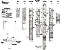
Figure 23. Columnar sections of tephra set S and diagram of their locations relative to the central vent
of the volcano. (48K)
|
Layer Sw
Layer Sw consists of at least 3 thin beds of small pumiceous and lithic
lapilli in ash that are characterized by a pale gray color, in contrast to the brown colors of other layers of
set S (fig. 24). Pumice in layer Sw probably is less vesicular than that in other set
S layers. Ferromagnesian mineral suites consist mostly of cummingtonite and hornblende; minor amounts of hypersthene
and oxyhornblende were found in some samples.
|
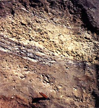
Figure 24. Tephra set S at the Muddy River quarry site about 11 km east of Mount St. Helens. The gray
color of the coarse ash and lapilli of layer Sw contrasts with the yellow and brown colors of other parts of the
set. Only a few centimeters of the lower part of layer So are present above layer Sg; the remainder of layer So
has been mixed into an overlying oxidized, ash-rich deposit by soil-zone processes. Pocketknife shown for scale.
Photograph taken in 1979. (169K)
|
Layer Sw is inconspicuous, and its identification depends chiefly on its pale gray color and thin beds and the
denser character of its pumice lapilli.
Locally, layer Sw directly overlies layer Sb, but more commonly it lies on
lenticular ash deposits of flowage origin. In some places, it is directly overlain by layer Ss. More commonly,
however, it is overlain by ash deposits of flowage origin or by layer Sg.
Layer Sw was identified from northeast to southeast of the volcano at distances
of as much as 16 km. Its maximum known thickness, however, is only slightly more than 5 cm. Both its broad distribution
(fig. 25) relative to its limited thickness and its multiple beds suggest that it consists
of multiple small shower beds that were carried in different directions.
|
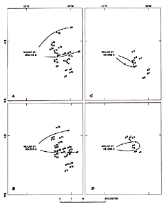
Figure 25. Measured thickness (in centimeters) of layers in tephra set S, Mount St. Helens. A, Layer
So. No measurement reported for layer So is likely to represent a primary thickness because of truncation of the
top of that layer. B, layer Sg. C, layer Ss. D, layer Sw. (24K)
|
Layer Ss
Layer Ss is a single, highly pumiceous brown stratum of well-sorted lapilli
and coarse ash (fig. 26). Although its maximum known thickness is less than 15 cm,
it is the thickest tephra shower bed in set S below the upper two layers. Its ferromagnesian minerals are mostly
cummingtonite and hornblende, but it also contains several percent hypersthene.
|
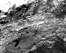
Figure 26. Layer Ss about 9 km southeast of the volcano. Here it is coarser than and about as thick as
layer Sg. Only irregular lenses of lapilli remain of layer So, which has been mostly mixed into an overlying ash-rich
deposit of undetermined origin. Pocketknife shown for scale. Photograph taken in 1979. (196K)
|
Layer Ss is identified by its brown color, highly pumiceous character, thickness,
and stratigraphic position between the usually distinctive layers Sw and Sg. Southeast of the volcano, it is coarser
and thicker than the underlying layer Sw. It is much thinner and finer than the overlying layer Sg everywhere except
toward the southeast, where locally the two are similar in grain size and thickness (fig.
26).
Although layer Ss directly overlies layer Sw in some outcrops, it more commonly
is separated from the latter by ash of flowage origin (fig. 20). It generally directly
underlies layer Sg, separated only by thin ash.
The layer was identified from east to southeast of the volcano. Toward the
east, it is thin or missing from many outcrops (figs. 20, 24).
It is thickest toward the southeast, where it is almost 10 cm thick at a distance of 10 km and contains abundant
small lapilli (fig. 26). It was not recognized only slightly farther west on the south-southeast
flank of the volcano, which suggests that westerly winds during its eruption produced an abrupt western margin
of its lobe.
Layer Sg
Layer Sg is a single, normally graded, grayish yellow to brown deposit of
pumice lapilli and bombs as thick as 50 cm (fig. 20). It is the most voluminous single
tephra unit of set S. Most clasts in this layer are pumice, but lithic fragments are common. Ferromagnesian mineral
suites consist of chiefly cummingtonite and hornblende and a few percent hypersthene; layer Sg thus is mineralogically
similar to pumice of most other layers in set S. The SiO2 content of a single sample analyzed from this
layer is between 63 and 64 percent.
Layer Sg is distinguished by its color, grain size and thickness, and graded
character. It is similar to the overlying layer So but is thicker and more strongly graded. Moreover, pumiceous
glass from layer Sg has slightly lower calcium and iron contents relative to potassium than pumice from layer So.
The difference probably is sufficient to distinguish between the layers using chemical analyses (Mullineaux and
others, 1978; Sarna-Wojcicki and others, 1983).
Layer Sg overlies layer Ss southeast of the volcano, and either layer Ss or
Sw toward the east and northeast (figs 20, 23). It is overlain
east and northeast of the volcano by layer So. Where layer So is absent toward the south-southeast, layer Sg commonly
forms the top of the set and is overlain by a thick, oxidized, ash-rich deposit that separates set S from set J.
Layer Sg crops out from northeast to southeast of the volcano and is the thickest
layer in set S in almost all such outcrops. It is thickest toward the east or east-northeast. Its lobe probably
is broad and has an axis that trends east-northeast. In that direction, the layer commonly is thick as 50 cm at
distances of 10-15 km (fig. 26) and consists mostly of lapilli and a few bombs. Farther
to the north, it apparently thins, but most outcrops are at higher altitudes and are disturbed. It thins progressively
southward from east of the volcano and is only about as thick as layer Ss on the the southeast flank.
Layer Sg was traced for about 40 km northeast of Mount St. Helens and has been
identified far downwind in eastern Washington (Mullineaux and others, 1978; Busacca and others, 1992), where it
forms a marker ash bed 1-2 cm thick.
Layer So
Layer So is a single yellow-brown layer of pumice lapilli and a few bombs
that is thick as 30 cm and forms the top of set S (figs. 20, 21).
Except for layer Sg, it is the thickest layer in the set. It contains only small amounts of lithic material, and
its ferromagnesian mineral suite consists of cummingtonite and hornblende and a few percent hypersthene. Chemical
analysis of one pumice sample from layer So showed a SiO2 content of between 62 and 63 percent.
The upper part of this layer typically is oxidized and disturbed by soil development
(figs. 24, 26), a result of near-surface exposure for 1,000-2,000
years before being covered by set J tephras.
Layer So is identified chiefly by its coarse, thick character and stratigraphic
position above layer Sg. East of the volcano, layer So differs from layer Sg by its darker color and less distinct
grading. Where only one of these layers is seen, identification can be based on distribution or chemical analysis.
Slightly higher amounts of calcium and iron relative to potassium in glass from layer So compared with those in
layer Sg distinguishes between these two layers (Mullineaux and others, 1978; Sarna-Wojcicki and others, 1983).
Wherever it has been found near the volcano, layer So overlies layer Sg. The
weathered, disturbed top of layer So typically is overlain by a thick, oxidized, ash-rich deposit or by pyroclastic-flow
deposits.
Layer So was identified from northeast to southeast of the volcano. Part of
the layer probably fell farther to the north but was not preserved well enough there for it to be identified. It
is thickest northeast and east of the volcano, where it is as thick as 30 cm at distances of 5-10 km and as thick
as 20 cm at 15-20 km (fig. 25); however, because the upper part of the layer is eroded
and weathered in all the outcrops observed, these thicknesses probably are less than primary thicknesses. Layer
So was traced to about 40 km northeast of Mount St. Helens and has been identified in eastern Washington about
200-300 km downwind (Mullineaux and others, 1978; Busacca and others, 1992).
Tephra Set J
Set J consists mostly of multiple coarse pumice layers that together form a thick, brown deposit characterized
by lapilli and bombs (figs. 27, 28) both east and west
of the volcano. Toward the east, two pumiceous lapilli and bomb layers overlie thin ash; to the west, the set consists
of one coarse, thick layer. Lithic material is sparse, and no layers of lithic fragments were found.
|
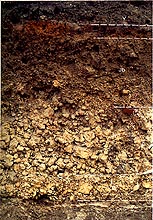
Figure 27. Coarse pumice layers of tephra set J about 8 km east of the central vent of Mount St. Helens.
Most of layer Jb here has been disturbed by near-surface processes. Locally, the deposit of colluvium and wind-blown
material above layer Jb contains identifiable lenses of ash from Mount Mazama. Pocketknife shown for scale. Photograph
taken in 1983. (147K)
|
A relatively strong brown color is characteristic of the set as a whole, and
its upper 20-40 cm generally has been strongly mixed by soil-zone processes. Associated ash of flowage origin is
not common and was not found interbedded with the major tephra layers of set J.
|
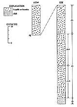
Figure 28. Columnar sections of tephra set J about 10 km east-southeast and west-southwest of the central
vent of the volcano. (18K)
|
Composition
Pumice makes up most of set J; it ranges in composition from dacite in the
lower part of the set to andesite in the upper. Pumice from the lower two layers Js and Jy contains only hypersthene
and hornblende as abundant ferromagnesian minerals, and has a SiO2 content between 62 and 64 percent.
The next younger layer, Jb, contains the same ferromagnesian minerals, but its SiO2 content is lower,
between 55 and 60 percent. Layer Jg at the top of the set also has a SiO2 content between 55 and 60
percent, but its ferromagnesian mineral suite consists of mostly hornblende, lesser amounts of hypersthene, and
traces of augite.
Diagnostic features
Set J is the only coarse, thick, and strongly oxidized tephra set at Mount
St. Helens that has a ferromagnesian mineral suite dominated by hypersthene and hornblende. These features readily
distinguish it from all other tephra sets of the volcano. In the field, set J can commonly be recognized simply
by its coarse grain size and color, which is darker than the yellow to pale-brown colors typical of the underlying
and overlying tephra sets S and Y.
Stratigraphic relations
Set J usually is separated from the underlying set S by an oxidized, ash-rich
deposit commonly 100 cm thick or by pyroclastic-flow deposits. Close to valley floors, pyroclastic-flow deposits
generally directly underlie set J. At one site, 9 km directly east of the volcano, thin remnants of three pyroclastic-flow
deposits, each of which contains a thin oxidation profile at its top, were observed between sets S and J about
50 m above the valley floor (Crandell, 1987, p. 33-34).
Near the volcano, set J generally is directly overlain by set Y, but the coarse
pumice at the top of set J typically has been strongly mixed by soil-zone processes during the period of 6,000-7,000
years that it was exposed at the surface before deposition of set Y. Locally near Mount St. Helens, Mazama ash
from Crater Lake, Oregon, can be identified between sets J and Y. More commonly, however, volcanic ash or other
fine material that fell on the coarse upper part of set J before set Y was erupted has simply filtered down into
the coarse pumice deposit. In contrast, where set J is finer at distances of more than about 10 km to the west
and 20 km to the east of Mount St. Helens, Mazama ash can commonly be recognized between sets J and Y.
Distribution and thickness
Set J has been identified in all directions from the volcano except to the
north. From the northeast to southeast, it typically consists of 50-100 cm of lapilli and small bombs at distances
of 5-15 km from the volcano. It is much thicker locally, especially to the southeast, but may have been overthickened
by slumping or creep. The set thins from the southeast around to the south, where it is 25-50 cm thick at comparable
distances (fig. 29). It crops out only sparsely north-northeast of the volcano and
has been strongly disturbed wherever found in that direction. Farther downwind toward the east, it is as thick
as 30 cm at a distance of 30 km and as thick as 1 cm at 200 km, and it has been identified as far as about 700
km from the volcano in Montana (Carrara and others, 1984, 1986).
|
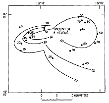
Figure 29. Approximate thickness (in centimeters) of tephra set J, Mount St. Helens. (13K)
|
Toward the west, set J consists of only one layer. Locally it is as thick as
250 cm at 5 km, but those thick deposits exhibit crude layering and may have been overthickened by slumping. The
layer generally is 30-50 cm thick at a distance of about 10 km through an arc from southwest to west (fig.
29).
No deposits of set J were recognized north of the volcano, even at relatively
low altitudes at a distance of 10 km where tephras of both sets S and Y are preserved; apparently little or no
tephra of set J was carried in that direction.
Age
Set J probably was erupted between 12,000 and 10,500 years ago, although
some evidence suggests its eruption could have begun several hundred years earlier. An older limiting age of less
than 12,000 and perhaps 11,500 years ago is indicated by several radiocarbon samples from near the volcano (table 2). Samples from just below the base of the set there have been dated between approximately
11,900 and 11,550 years B.P. (Crandell and others, 1981) W-2866, W-2441, W-2832, W-2870 (table
2); thus, multiple samples indicate that the eruptions began after 12,000 years ago and perhaps as recently
as about 11,500 years ago.
Samples from lacustrine deposits downwind, however, suggest that set J eruptions
might have begun as early as about 12,500 years ago (Carrara and Trimble, 1992; P.E.Carrara, written commun., 1993).
Similar discrepancies, in which lacustrine samples indicate an age older than terrestrial ones, have been noted
in Canada by Mathewes and Westgate (1980), and in Alaska by Riehle and others (1992), who emphasize the uncertainty
in comparing dates of terrestrial and lacustrine samples.
The younger limiting date of about 10,500 years is based chiefly on samples
from peat bogs that are several tens of kilometers from Mount St. Helens (table 2). Peat
from a site 70 km to the east-southeast that was dated at about 10,740 years B.P. (W-5718) came from above layer
Jb, the youngest layer of the set that extends in that direction. At 45 km south-southwest of Mount St. Helens,
peat from above layer Jg, believed to be the youngest layer of set J, was dated at approximately 10,580 years (W-5731).
When first described (Mullineaux and others, 1972, 1975), the younger part
of set J was thought to be between 9,000 and 8,000 years old. Three radiocarbon samples of charcoal from coarse
pumice deposits of set J east of the volcano were dated as approximately 8,300 (W-2587), 8,430 (W-2702), and 8,900
(W-2991) years B.P. (table 2). Recent dates from above set J that are older than 10,000
years indicate that the dates younger than 9,000 years are not valid. Resampling of material similar to that dated
as 9,000 to 8,000 years old suggests that the anomalous dates may have resulted from contamination. Apparently
the charcoal fragments that gave those dates were contaminated by younger humic or other carbonaceous material
during the long period that the coarse pumice was exposed at the surface, and the dates should be disregarded.
Description of layers in set J
Set J includes only a few traceable strata, and its sequence is not complicated
by ash deposits of flowage origin. Four layers are recognized in the set; a thin, basal ash deposit and three coarser,
thicker strata, two of which extend toward the east and one toward the west (fig. 30).
The layer that extends toward the west is the thickest tephra deposit known on the flanks of Mount St. Helens.
Ash containing carbonaceous fragments at one site between two beds or zones of the layer that extends to the west
suggests a pause may have occurred during eruption of layer Jg, but no such zones were found in that layer in other
outcrops nearby.
|
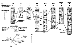
Figure 30. Columnar sections of tephra set J from northeast to west of Mount St. Helens, and diagram
of their locations relative to the central vent of the volcano. (42K)
|
Measured section J-1
West side of Smith Creek valley, about 50 m northwest of site of bridge that crossed Smith Creek in 1983, in
NE1/4 SE1/4 sec. 5, T. 8 N., R. 6 E. See figure 27.
| |
|
Thickness
(centimeters) |
| 5. |
Set Y. Ash and lapilli of layer Yb; charcoal at base |
5-10 |
| 4. |
Colluvium, ashy; contains lenses of ash from Mount Mazama |
3-6 |
| Set J |
|
|
| 3. |
Layer Jb. Pumice lapilli and ash, brown; openwork in
lower 10 cm, mixed and ash rich in upper 15 cm |
20-30 |
| 2. |
Layer Jy |
|
| |
Bed Jyn. Pumice lapilli and bombs in sparse ash; openwork; fragments coated with gray ash
|
25-35 |
| |
Bed Jyo. Pumice lapilli, brown, and a few bombs; openwork
|
5-10 |
| 1. |
Ashy sand and pumice pebbles; probable reworked material
from pyroclastic-flow deposits and layer Js |
>30 |
| Base not exposed |
|
|
Layer Js
Several thin, compact, grayish-brown, poorly sorted pumiceous ash beds containing
scattered small pumice lapilli crop out widely but discontinuously at the base of the set and are grouped together
as layer Js. No individual beds in the layer were traced from one outcrop to another. Typically, the layer is faintly
planar bedded; no crossbedding was seen. Ferromagnesian mineral suites from pumice consist essentially of hypersthene
and hornblende, and a single sample analyzed chemically has a silica content of about 62 percent. Layer Js differs
from other layers in set J by its fine grain size, lesser thickness, and greater compactness.
On uplands, layer Js commonly is separated from set S by a thick, fine-grained,
oxidized ash-rich deposit that probably originated in part from flowage phenomena. Near and on valley floors, pyroclastic-flow
deposits almost everywhere separate layer Js from set S. The coarser layer Jy overlies layer Js throughout the
known extent of the finer layer.
Layer Js was identified only east and southeast of the volcano (fig.
31). Its maximum thickness is about 5 cm at distances of 5-8 km toward the east and southeast; the farthest
from the volcano that it was identified is 13 km toward the east-southeast. The layer was identified only where
it is overlain by the coarse layer Jy, and its possible extent farther around the volcano is not known.
The planar bedding and thin, widespread character of layer Js suggests that
it originated as a fall deposit, but it may have been deposited in part by ash clouds from flowage events.
|
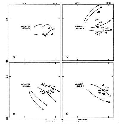
(42K)
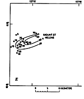
(6K)
Figure 31. Thickness (in centimeters) of layers in tephra set J, Mount St. Helens. A, Layer Js. B, Bed
Jyo. C, Bed Jyn. D, Layer Jb. E, Layer Jg.
|
Layer Jy
Layer Jy consists of two similar, thick, well-sorted beds of grayish-yellow
to brown pumice lapilli and bombs, designated Jyo and Jyn (figs. 27, 32).
Bed Jyo is mostly south and east of the volcano, and the overlying bed Jyn extends from southeast to northeast.
The two beds overlap on the east and southeast, but that overlap is evident only in well-preserved stratigraphic
sequences. Elsewhere, the layer apparently consists of only a single bed. Ferromagnesian mineral suites in both
beds consist almost entirely of hypersthene and hornblende. Whole-rock samples of pumice from layer Jy contain
about 63 percent SiO2.
|
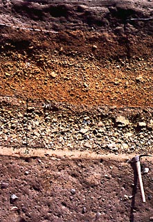
Figure 32. Layer Jy between layers Js and Jb 9 km southeast of the volcano along USFS Road N83 where
it crosses the Muddy River. Bed Jyn, about 8 cm thick, overlies bed Jyo, which is about 30 cm thick. Layer Js here
overlies a pyroclastic-flow or lahar deposit. Photograph taken in 1983. (152K)
|
Along their respective distribution axes, beds Jyo and Jyn are similar in thickness,
grain size, and color; where they overlap, they are not separated by a distinct ash stratum. In some outcrops showing
overlap, they can be distinguished by differences in texture or in the color of interstitial ash. Ash in bed Jyn
typically is more reddish than the yellowish-brown color typical of bed Jyo. Even in the zone of overlap, however,
layer Jy could not be subdivided reliably in many outcrops.
Layer Jy is easily distinguished from layer Js by its coarser grain size and
greater thickness. Where layer Jy and the overlying layer Jb are present together, layer Jy commonly is slightly
coarser, thicker, and lighter brown. In most outcrops south and southeast of the volcano, however, the two were
not different enough to be separated in this study.
Layer Jy overlies layer Js or forms the base of the set, in which case it lies
on either an oxidized, ash-rich deposit or on pyroclastic-flow deposits that separate it from set S. Layer Jy is
overlain by identifiable layer Jb in some outcrops toward the east-southeast and by set Y in other directions.
Layer Jy forms a broad lobe from northeast to south of the volcano. The older
bed Jyo probably makes up the entire layer on the south and is also thick toward the southeast (fig.
32). Bed Jyn makes up much of the layer on east (fig. 27), and probably most or
all of it on the northeast. The thickness of the two beds together in the zone of overlap at about 10 km from the
volcano is approximately the same as the thickness of beds Jyn and Jyo along their respective axes.
East-southeast of the volcano, at a distance of 10 km, bed Jyo is 30-40 cm
thick and contains abundant lapilli and small bombs as much as 10 cm across. It thins westward across the south
flank of the volcano and does not form a well-defined stratum farther to the west, on the southwest flank of the
volcano. The northern margin of its lobe is relatively abrupt; 13-14 km east-southeast of the volcano, it thins
northward from 30 to 15 cm over a distance of about 2 km and was not identified only 1 km farther to the north
(figs. 30, 31).
Bed Jyn is thickest northeast of the volcano. At about 9 km in that direction,
it is 60-70 cm thick (figs. 30, 31). To the north-northeast,
it is much disturbed and poorly preserved in outcrops close to the volcano, and it is uncertain whether or not
it is thicker or coarser in that direction. From the northeast, the layer thins clockwise around the volcano (figs. 27, 31) and was identified only around to about southeast
of the volcano.
In many outcrops on steep slopes, layer Jy is anomalously thick both northeast
and south of the volcano. These deposits may have been overthickened by slumping as they fell or by later reworking,
but they could be a result of unidentified tephra lobes that extend in those directions.
Layer Jy forms an important marker bed, and its downwind component probably is one of the ash beds correlated with
set J in eastern Washington about 200 km from the volcano (Moody, 1978) and the set J ash bed identified in Montana
about 600 km from the volcano (Carrara and others, 1986).
Beds Jyo and Jyn may represent two stages of one eruption or two distinctly
different events. No evidence was seen to indicate how much time might have elapsed between two such stages or
eruptions. The overlapping relation of two well-defined beds probably precludes origin from a shift in wind direction
during a single continuous eruption.
Layer Jb
Layer Jb is a single bed, at least 30 cm thick, of brown pumice lapilli
and small bombs. It overlies layer Jy (figs. 27, 30, 31) and forms the top of set J east and southeast of Mount St. Helens. Similar to older
layers in the set, Jb contains only hypersthene and hornblende in its ferromagnesian mineral suite. Where it has
been identified overlying layer Jy, layer Jb commonly is more reddish brown and locally is finer grained; however,
no field or mineralogical criteria are known that reliably distinguish between the two. Where stratigraphic relations
do not distinguish between them, chemical analyses may. Whole-rock and glass analyses of pumice from layer Jb indicate
that it contains less silica and more iron than pumice from the older layers of set J (appendix)
(J.A., Westgate , written commun, 1972).
Throughout its known extent, layer Jb directly overlies layer Jy, and near
the volcano layer Jb is overlain by set Y. Locally, Mazama ash is preserved between layer Jb and set Y.
Layer Jb is present from east to southeast of the volcano and was not identified
north of that trend. It also was not identified west of a line leading south-southeast, although it might be hidden
there in the disturbed zone at the top of the set. At 10 km to the east-southeast, it is as thick as 30 cm and
contains lapilli as much as 5 cm across (figs. 29-30-31). At 20 km in that direction, it consists of small lapilli and ash about 10 cm thick.
At that site, it is coarser than layer Jy, even though Jy is coarser at that distance in other directions, because
the locality is along the downwind axis of layer Jb but between the downwind axes of beds Jyo and Jyn.
Layer Jg
Layer Jg is a thick, conspicuous deposit of well-sorted, gray-brown pumice
lapilli and bombs on the west and southwest flanks of the volcano. Its pumice generally is darker, especially on
freshly broken surfaces, than pumice in other layers of set J. Crude bedding of layer Jg in many places (fig.
33) may record multiple eruption pulses, more than one shower bed, or simply downslope movement caused by a
rapid rate of fall. The ferromagnesian mineral suite of layer Jg consists chiefly of hornblende that is darker
and browner than hornblende in other layers of the set; the suite also contains hypersthene in lesser amounts and
sparse augite. A single chemical analysis of pumice from layer Jg showed a SiO2 content of between 57 and 58 percent.
|
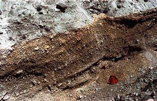
Figure 33. Crude bedding in layer Jg, about 5 km southwest of the center of Mount St. Helens. Small pack
at base of outcrop is about 50 cm high. (125K)
|
The upper part of layer Jg typically is oxidized and mixed by soil-zone processes
to depths of a few tens of centimeters. Overall, the entire layer is darker in outcrop than are other pumice units
in set J.
Layer Jg is readily identified on the west side of the volcano because it is
the only thick deposit of pumice lapilli there. Downwind, it can be distinguished from other pumiceous tephras
by its ferromagnesian mineral suite.
Because other layers of set J are absent west of the volcano, layer Jg generally
lies directly on set S tephra or on ash deposits of undetermined origin. Layer Jg generally is overlain by set
Y tephra or by ash-cloud deposits associated with that set. Locally, Mazama ash is preserved between layer Jg and
set Y.
Stratigraphic evidence that layer Jg is younger than other layers of set J
was found at only one site, in a peat bog 45 km south-southwest of the volcano. There, a thin ash bed whose ferromagnesian
mineral suite identifies it as layer Jg overlies peat that in turn overlies an ash bed whose ferromagnesian suite
is similar to that of set J layers east of the volcano. That relation indicates that layer Jg is younger than at
least part of the set J deposits east of the volcano. It is likely that it is also younger than all the set J layers
east of the volcano. A single change in ferromagnesian mineral composition from that of the layers east of the
volcano to that of layer Jg is more likely than two changes that include a reversal, from that of layer Jy to that
of Jg and then back to that of layer Jb.
Layer Jg probably overlaps layer Jy on the south-southwest flank of Mount St.
Helens. Both layers are thin there, however, and are so strongly disturbed that their stratigraphic relation could
not be confirmed.
Layer Jg forms a short, broad lobe toward the west and southwest. Its lobe
axis near the volcano is along a bearing of about 250 degrees (fig. 31). At 5 km from
the center of Mount St. Helens, layer Jg is as thick as 250 cm and consists almost entirely of bombs and lapilli.
These great thicknesses may have resulted, however, from slumping and accumulation in swales during rapid deposition.
Layer Jg decreases more rapidly in thickness and grain size away from the volcano than do tephras carried to the
east. At 10 km, layer Jg is only about 30 cm thick, and its thickness decreases progressively to about 10 cm at
15 km and 1 cm at 25 km.
Layer Jg is a useful marker bed for a few tens of kilometers downwind because
its composition makes it readily identifiable. Its range probably is limited compared with layers carried eastward,
however, and its downwind extent is not known.
The unusually great thickness of layer Jg, and the rapid decrease of thickness
with distance, suggests either that its eruptive column rose to a relatively low altitude or that eruption occurred
during a time of weak winds.

