
PRE-1980 TEPHRA-FALL DEPOSITS ERUPTED FROM MOUNT ST. HELENS, WASHINGTON
By Donal R. Mullineaux
U. S. Geological Survey Professional Paper 1563
DESCRIPTION OF TEPHRA UNITS
The following sections are written for reference rather than for continuous
reading. Brief descriptions of these tephras have already been published (Mullineaux, 1986). In the following sections,
each set is first described as a whole, including its composition, diagnostic features, stratigraphic relations,
distribution and thickness, age, and origin if appropriate. Tephra sets are described as overall units because
many have distinctive characteristics (fig. 6). Sets are especially important as markers
for stratigraphic correlation and age determination around the volcano because they are present in much wider arcs
around it than are individual layers.
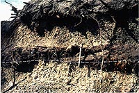
Figure 6A. Field characteristics of tephra units, Mount St. Helens.
A, Road cutbank about 10 km northeast of the volcano. Coarse grain size and white color of the lower unit shown
identify tephra set W, which here consists almost entirely of layer Wn. Tephra set W is overlain by the dark, fine-grained
set X, and in turn by the light-gray to brown, coarse-grained layer T. The brown color of layer T results from
iron staining in a surficial soil zone. Dark-gray ejecta from the 1980 eruptions lie at the top of the outcrop.
Fine-grained set X here forms a slight ledge in this outcrop. The ledge causes small particles of layer T and the
1980 deposits to cover the base of layer T, which is not finer in its lower part as the photograph might suggest.
Small pick shown for scale. Photograph taken 1982. (165K) |

Figure 6B. Outcrop above quarry, at 9 km bearing 055 degrees from the
volcano. Tephra set S overlies glacial drift; tephra set S consists of coarse, pale layers Sg and So overlying
ash-size deposits. Set J is made up here of one lapilli bed and is separated from set S by a thick, oxidized ash-rich
deposit. Set Y consists of lapilli-and-bomb layers Yb and Yn interbedded with ash. Set P is characterized by pale,
thin layers; a flowage deposit is interbedded with the tephra here. Set B is relatively dark and also is characterized
by thin layers. Set W, about 100 cm thick, consists chiefly of lapilli and bombs of layer Wn at this site. Photograph
taken in 1970. (119K) |

Figure 6C. Road cutbank about 14 km northeast of the volcano. Roadcut
exposures over a wide area northeast of Mount St. Helens show distinct pale bands of pumice lapilli separated by
darker bands of chiefly ash. Here, pale layer T lapilli are underlain by the dark band of set X, which separates
the layer from the coarse, pale set W (mostly layer Wn). Tephra set W is about 125 cm thick here. Sets B and P
and the upper part of set Y form a dark ash stratum below set W. In a fresher exposure, layer Yn in the lower part
of set Y would be seen as another stratum of pale lapilli (see Fig.
34). Photograph taken in 1983. (158K) |
After the summary for each set, I describe the same characteristics for each
layer of each set except set K. Although this arrangement results in some repetition, it is used to provide pertinent
information about each set and each layer in the description of that unit rather than repeatedly referring to other
places in the text where such information can be found.
Tephra Set C
Tephra set C consists chiefly of an upper part that contains three coarse,
white or pale-yellowish brown-pumice lapilli layers that are interbedded with ash overlying a basal layer consisting
of moderately vesicular to dense ash (figs. 7, 8). At 10-15
km from the volcano, the pumice layers consist of lapilli and bombs several tens of centimeters thick, and the
basal ash layer commonly is 100 cm thick. Except for the basal ash, ash-size tephra units are thin; probable thin
tephra beds are between pumice lapilli layers of the upper part, interbedded with thick ash of probable flowage
origin. Set C was identified from the east of the volcano clockwise around to southwest.
|
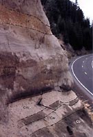
Figure 7. Tephra set C along USFS Road 25 about 17 km southeast of Mount St. Helens (measured section
C-1). The oldest tephra recognized here consists of about 100 cm of layer Cb, which overlies 50-100 cm of brown
colluvium, which in turn overlies bedrock. Layer Cb is overlain successively by (1) pale layer Cw, (2) dark ash,
and (3) pale layer Cm. About 200 cm of ash that includes thin tephra beds among thicker ash-cloud deposits separates
layer Cm from the coarse layer Cy at the top of the set. Shovel handle is about 50 cm long. Photograph taken in
1986. (114K)
|
Set C overall is noticeably oxidized and generally brown in color. Pumice fragments
are weathered strongly enough to be soft and easily crushed by hand. Many denser fragments are also weathered enough
to be soft.
|
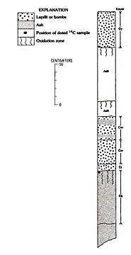
Figure 8. Composite columnar section of tephra set C, Mount St. Helens. (16K)
|
Composition
Tephra set C consists chiefly of pumiceous to slightly vesicular glassy
tephra, but all strata contain some dense fragments. Lapilli layers consist mostly of pumice, whereas ash layers
contain more particles that are moderately vesicular to dense. Ferromagnesian mineral suites from all strata examined
are mostly cummingtonite and hornblende and lesser amounts of biotite; biotite crystals commonly are relatively
large and exhibit embayed margins. Scattered brown hornblende phenocrysts are common in pumice at the top of set
C but are sparse in pumice from lower in the set. Small amounts of hypersthene are common. A few chemical analyses
indicate a range of about 62-64 percent SiO2 for the pumice in set C.
Diagnostic features
Set C strata can usually be distinguished by soft, weathered clasts, biotite
content, and stratigraphic position at the base of the tephra sequence. In most, but not all strata, biotite is
abundant enough to distinguish set C from the overlying sets M and K. Throughout its known range, set C as a whole
is generally at least twice as thick as set M or set K.
Stratigraphic relations
No tephra from Mount St. Helens was identified below set C. Set C generally
lies on a brown, clayey soil developed in colluvium or glacial drift. It is overlain by 100-200 cm of an oxidized,
massive to faintly bedded ash-rich deposit of undetermined origin. In most outcrops that deposit clearly separates
set C from set M or any other younger tephra.
Distribution and thickness
Set C was recognized from east of the volcano around to the southwest (fig. 9), generally at altitudes of less than about 600 m. This distribution probably reflects
limited preservation rather than initial extent. Tephra that was deposited at higher altitudes has been either
eroded away or so modified that it was not identified.
|
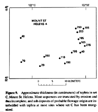
Figure 9. Approximate thickness (in centimeters) of tephra in set C, Mount St. Helens. Most sequences
are truncated by erosion and thus incomplete, and ash deposits of probable flowage origin are interbedded with
tephra at most sites where set C has been recognized. (38K)
|
Toward the east and south-southeast, layers of set C have been identified in
eastern Washington and Nevada, as far as 300 and 700 km, respectively, from the volcano (Davis, 1985; Busacca and
others, 1992). Toward the southwest, however, the set was identified only as far as about 40 km from Mount St.
Helens.
Set C is one of the thickest tephra sets at Mount St. Helens. Both east and
southeast of the volcano, relatively complete sequences of the set are about 200 cm thick (fig.
9). In many outcrops, set C appears even thicker because interbedded ash deposits of other origins are 100-200
cm thick. The set is thinner in most outcrops toward the south (fig. 9) but is locally
very thick on the southern flank of the volcano.
Origin
The major pumice lapilli layers in set C are clearly tephra deposits that
record voluminous plinian-type eruptions. Some interbedded, locally thick ash beds exhibit cross bedding and other
characteristics that indicate they are not fall deposits, and these beds are not further described here. Still
other ash beds that are thin and lie between layers Cm and Cy probably are tephra strata but could not be traced
well enough to identify them confidently as such, and they are not separately identified or described.
Age
Radiocarbon samples from set C tephras provide ages between 40,000 and 35,000
years. Ages of about 37,600 and 36,000 years (samples W-2661 and W-2976, respectively, Table
2) were obtained from carbonized wood taken from the set, but neither sample is from its base; both are younger
than the basal tephra. In addition, a sample from a lahar of Ape Canyon age provided an age of approximately 36,000
years ( Crandell and others, 1981). These dates have large uncertainties, however, and none provides an age for
the start of the tephra sequence.
Some other evidence suggests that the Ape Canyon stage and eruption of set
C started before 40,000 years ago. One radiocarbon age of more than 42,000 years (sample W-3259, Table
2) was obtained from charcoal in a pumiceous pyroclastic flow of the Ape Canyon stage (Crandell, 1987). Moreover,
in eastern Washington, two cummingtonite-bearing ash beds older than one identified as layer Cw have been suggested
to be possible correlatives of layer Cb or an older tephra not found at Mount St. Helens (Busacca and others, 1992).
In addition, the carbon that provided the oldest radiocarbon age from the tephra
sequence, from the oxidation profile in layer Cb (fig. 8), may have been laid down after
most of that oxidation had occurred. The oxidation profile itself may have required thousands of years to form.
At present, the pumice lapilli layers of set C, all of which are above the
basal layer Cb, are regarded to be between about 40,000 and 35,000 years old. Layer Cb, however, may be as much
as about 50,000 years old (Crandell, 1987; Busacca and others, 1992).
Previous designations and correlative units
Deposits of set C were initially included in the unnamed, oldest tephra
set of Mullineaux and others (1972).
Description of layers in set C
Figures 7, 8, 10
and 11 and measured sections C-1 and C-2 illustrate the stratigraphy of set C. Except
for layer Cs, all strata described in the set are represented at measured section C-1 and(or) C-2. Correlation
of specific layers in the set from one site to another is problematic. Outcrops are sparse, and many layers are
obviously partly eroded, such that thicknesses and grain-size characteristics cannot be readily compared from one
outcrop to another. Evidence from thick layers such as Wn and We in the young and well-preserved set W show that
coarse and thick pumice layers in the same apparent stratigraphic position in outcrops only a few kilometers apart
are not necessarily parts of the same shower bed. Thus, even the major layers in set C, except layer Cb, are only
provisionally correlated from place to place around the volcano.
|

Figure 10. Columnar sections of tephra set C from east to south-southwest of Mount St. Helens and diagram
of their locations relative to the central vent of the volcano. (53K)
|
The relation of layer Cs to layer Cy has not been resolved. The two may be
parts of the same deposit. Layer Cs is described separately because it is so coarse and thick south of the volcano,
and it is present so far downwind to the south-southeast.
Oxidation profiles within set C record pauses during accumulation of the set
(fig. 8). The most oxidized profile is in the upper part of the basal layer Cb, and
as many as three other oxidation profiles are present between layers Cm and Cy. Field examination of these profiles
at the Muddy River quarry by P.W. Birkeland of the University of Colorado suggested that they might contain significant
amounts of pedogenic clay; however, laboratory analyses showed that most of the fine material is silt rather than
clay and that recognizable soil development consists chiefly of oxidation (P.W. Birkeland, written commun., 1973).
Measured section C-1, Road 25 site
East side of USFS Road 25, in SE1/4 SE1/4 sec. 36, T. 8 N., R. 6 E., 2.2
km along road from bridge across Muddy River. Tephras exposed above rock face in road cut (fig.
7).
| |
|
Thickness
(centimeters) |
| 16. |
Ash: overlies set C. Contains three oxidation profiles |
150-200 |
| Set C |
|
|
| 14. |
Layer Cy. Pumice lapilli and ash, light-yellow-brown: grades finer from bottom to top; contains lapilli as much
as 5 cm across in lower part. Upper contact wavy, gradational, and probably eroded; pumice lapilli commonly weathered,
soft, and sheared off parallel to outcrop
face |
35-50 |
| 13. |
Ash, coarse and fine, faintly bedded, locally crossbedded, pale-brownish-gray; upper 25-30 cm weakly oxidized;
contains accretionary lapilli and thin lenses of small pumice lapilli; carbonaceous material common at base |
60-70 |
| 12. |
Ash, fine, bedded, locally crossbedded, brown to grayish-brown, slightly oxidized in upper 10-15 cm |
15-25 |
| 11. |
Ash and small pumice lapilli, thin-bedded; relatively continuous but thickness varies from 2 to 12 cm at this outcrop;
possibly tephra |
7 |
| 10. |
Ash, fine, laminated; contains thin lenses of pumice; locally fills channels |
15-40 |
| 9. |
Small pumice lapilli in ash, well sorted; probable tephra |
1-2 |
| 8. |
Ash, bedded, brownish-gray; contains at least five couplets of fine and coarse ash |
7 |
| 7. |
Ash and small lapilli, faintly planar bedded; bedding locally contorted; contains thin lenses rich in carbonaceous
material; upper half slightly oxidized |
40-80 |
| 6. |
Layer Cm. Pumice lapilli and ash, brownish-gray to brown; crudely bedded or zoned, relatively fine in upper 15
cm; coarser zones near base and middle; contains pumice lapilli as much as 3 cm across, and abundant dark-stained
lithic lapilli near middle of unit |
45 |
| 5. |
Ash, gray to brownish-gray, pumiceous |
10 |
| 4. |
Layer Cw. Yellow-gray pumice lapilli as much as 4 cm across and dark-stained lithic fragments in ash; slightly
finer in upper 10-15 cm |
25 |
| 3. |
Ash, fine, gray, sticky; at base of layer Cw |
2 |
| 2. |
Layer Cb. Ash, planar-bedded to massive; near base coarse brown ash beds alternate with finer grayer beds; remainder
mostly disturbed and oxidized but locally contains lenses of gray, bedded ash; carbonaceous material common near
top |
70-100 |
| Below set C |
|
|
| 1. |
Colluvium, oxidized, brown; overlies bedrock |
70 |
Measured section C-2, Muddy River quarry site
East bank of Muddy River at its confluence with Smith Creek, near the center
of NW1/4 sec. 15, T. 8 N., R. 6 E. Tephras crop out above the rock face of quarry along an abandoned section of
former USFS Forest Road N92 (fig. 11). Most tephras vary substantially in thickness
across the outcrop. Thicknesses reported are estimates of average thickness or ranges observed at this outcrop.
| |
|
Thickness
(centimeters) |
| 10. |
Ash, oxidized, overlies set C |
150-200 |
| Set C |
|
|
| 9. |
Layer Cy. Pumice lapilli and ash; upper 15-20 cm relatively fine grained, yellow brown; basal 5-10 cm partly bleached
to pale gray; charcoal common at base (source of radiocarbon sample W-2976 (table 2), dated as 36,000 + - 2,500
yr B.P.) |
60 |
| 8. |
Ash; contains scattered moderately vesicular lapilli; gray at base, grades upward to brown in oxidation profile
in uppermost 30-40 cm |
90 |
| 7. |
Ash, lithic and pumiceous, brown to gray; oxidation profile visible locally in uppermost 10-15 cm |
25 |
| 6. |
Layer Cm. Small pumice lapilli and ash, yellowish brown
Small lapilli in ash
|
20 |
| |
Ash
|
1 |
| |
Small lapilli in ash: many fragments stained dark
|
5 |
| |
Ash
|
1 |
| |
Small lapilli in ash, crudely bedded
|
10 |
| 5. |
Ash, below lowest lapilli of layer Cm |
2 |
| 4. |
Layer Cw. Chiefly pumice lapilli and small bombs, massive, pale-gray to yellowish-brown; pumice in basal 10 cm
is bleached and clay rich |
40 |
| 3. |
Layer Ct. Small pumice lapilli and ash
Ash, fine to coarse, gray,
|
6 |
| |
Small lapilli and ash; two beds evident locally
|
2-5 |
| |
Ash, fine, gray
|
2 |
| 2. |
Layer Cb. Moderately to nonvesicular ash containing scattered
lapilli, massive to planar-bedded; brownish gray at base, upper part brown in oxidation profile; oxidation profile
extends down 30-40 cm from top and contains scattered charcoal (source of radiocarbon sample W-2661 (table 2),
dated at 37,600 + - 1,300 years B.P.) |
100 |
| Below set C |
|
|
| 1. |
Colluvium, brown, strongly oxidized, overlies bedrock |
75-100 |
Layer Cb
Layer Cb consists of several tens of planar, thin- to thick-bedded strata
of moderately vesicular to dense ash that includes scattered lapilli and small bombs. These strata vary considerably
in grain size and sorting, and some are graded. Their ferromagnesian mineral suites consist of mostly cummingtonite
and hornblende and lesser amounts of biotite, but biotite was not found in all samples of the layer. Clinopyroxene
was found in some samples, and several percent of hypersthene was found in one sample. Overall, pyroxene was sparse
or absent in most samples examined.
In many outcrops, the entire layer is weathered to brown, and bedding is obscure.
Locally, the lower part is gray and less weathered, and shows distinct bedding. The oxidation profile (fig.
11) at the top of layer Cb is as thick as 70 cm and commonly contains small carbonaceous fragments.
|

Figure 11. Lower part of tephra set C at the Muddy River quarry site, 11 km east of Mount St. Helens
(measured section C-2). Scraped part of outcrop shows about 100 cm of layer Cb over colluvium that lies on bedrock;
a brown oxidation profile extends 30-40 cm down into layer Cb from its top. Layer Cb is overlain by (1) gray ash
and lapilli of layer Ct, (2) yellow-brown pumice of layers Cw and Cm, and (3) gray-brown ash that lies between
layers Cm and Cy (layer Cy was not dug out here). Shovel is approximately 100 cm long. Photograph taken in 1979.
(145K)
|
Layer Cb is recognized by its grain size, multiple thin beds, thick oxidation
profile, and basal stratigraphic position. It is the oldest eruptive deposit from Mount St. Helens found in stratigraphic
successions and commonly lies on weathered colluvium or glacial drift. It is overlain locally by thin layer Ct
but generally by other layers of set C.
Layer Cb was found from east of the volcano clockwise around to south, chiefly
at altitudes of less than 600 m. It commonly is about 100 cm thick 10-15 km east and southeast of the volcano and
apparently thins rapidly from the southeast around to the south and with increasing distance from the volcano.
This layer probably originated from repeated small-volume, explosive eruptions
of partly degassed magma. In places the deposits are similar in grain size and thickness to those resulting from
pyroclastic flowage events, but crossbedding or other evidence of flowage was not seen.
No carbonaceous material that might provide a date for the onset of eruptions
of set C was found associated with layer Cb. The oldest dated carbon recovered anywhere from the Mount St. Helens
tephra sequence is from the oxidized zone in the upper part of layer Cb (measured section C-2); it was dated as
approximately 37,600 years old (table 2, sample W-2661). That carbon probably had been
mixed downward into the oxidized part of the layer by turnover within a soil zone. If so, the carbonaceous material
is younger than the topmost bed of layer Cb and younger than part of the oxidation. Neither the time that elapsed
between deposition of the top of layer Cb and formation of that carbonaceous material nor the time represented
by the oxidation is known.
Ash from Mount St. Helens in eastern Washington, possibly correlative with
layer Cb, has been estimated to be as much as about 50,000 years old (Busacca and others, 1992).
Layer Ct
Layer Ct consists of as many as three thin, poorly defined beds of small
lapilli enclosed in ash. At measured section C-2, two zones of lapilli are separated by and enclosed in ash. More
than one eruption may have formed this layer, but the multiple lapilli beds might represent only changing conditions
during a single eruption. Cummingtonite and hornblende make up most of the ferromagnesian mineral suite of this
layer. No diagnostic features were recognized that differentiate layer Ct from other pumice layers in set C; it
is identified only as a lapilli-bearing layer that directly overlies layer Cb.
Layer Ct directly overlies the oxidized top of layer Cb and underlies the coarser
layer Cw. It was recognized only toward the southeast, within 15 km of the volcano.
Layer Cw
Layer Cw is a single thick, relatively massive deposit that contains pumice
lapilli and bombs. It typically is pale brownish gray and locally has a bleached, white zone of soft, clayey pumice
at its base. Its ferromagnesian mineral suite consists chiefly of cummingtonite, green to olive hornblende, and
biotite; brownish hornblende is sparse.
The layer is generally coarser grained than layers immediately below and above
it. It is the coarsest layer in the set except for layers Cy and Cs at the top. Its identification is based chiefly
on its grain size and thickness and its stratigraphic position in the set. In most outcrops, its clayey basal zone
and massive character distinguish it from layer Cm, and the paucity of brown hornblende in its ferromagnesian suite
generally distinguishes it from layer Cy at the top of the set.
In some places, layer Cw overlies layer Ct; elsewhere, it lies directly on
layer Cb. Where it has been recognized, it is overlain by layer Cm.
The layer is well exposed east and southeast of the volcano, where it is about
40 and 25 cm thick at 11 and 17 km, respectively. It is similarly thick at several other sites within about 3 km
of those locations, but was not identified farther around the volcano. A single pumice lapilli layer in the lower
part of set C on the south side of the volcano might be correlative with layer Cw, but that possibility could not
be confirmed. Because it is thick and coarse grained, layer Cw should make a recognizable marker bed downwind.
About 300 km to the east, a layer identified as Cw has been found in at least four different sites (Busacca and
others, 1992).
Layer Cm
Layer Cm consists of pumice and lithic lapilli and ash in a deposit that
typically is crudely stratified. At the Muddy River quarry, three beds or zones of lapilli are interbedded with
ash (measured section C-2). The lower bed consists dominantly of crudely bedded pumiceous ash and lapilli. Lapilli
in the middle bed are smaller and consist of about equal parts of pumice and lithic fragments, many of which are
stained black. The upper bed consists of ash and lapilli that contain abundant lithic fragments. The ferromagnesian
mineral suite of layer Cm is dominated by cummingtonite and green to olive hornblende; it also contains biotite
and sparse brownish hornblende.
The stratification, stained lithic fragments, and lack of a zone of soft, weathered
pumice at its base best distinguish layer Cm from layer Cw. Those same features, as well as its paucity of brownish
hornblende and stratigraphic position, distinguish it from layer Cy.
Layer Cm directly overlies layer Cw. It is overlain by ash beds that contain
as many as three oxidation profiles and separate it from the pumice layer Cy at the top of the set (fig.
7).
Layer Cm was identified from approximately east to southeast of the volcano,
where it is as thick as 30 cm at a distance of almost 20 km. On the south flank of the volcano, only a single pumice
lapilli layer was seen in the lower part of set C, and whether it is layer Cw, Cm, or yet another layer is not
known.
The grain-size changes that produce the stratification in layer Cm could have
resulted from multiple small eruptions or perhaps only from fluctuations in strength of a single eruption, such
as occurred at Mount St. Helens on May 18, 1980.
Layer Cy
Layer Cy is a single, normally graded pumice deposit that is the thickest
layer east of the volcano, where it forms the top of set C (fig. 8). At the Muddy River
quarry 11 km east-southeast of the volcano, the layer consists of 60 cm of mostly pumice lapilli and small bombs.
It also contains as much as about 10 percent lithic fragments. Mineralogically, it is similar to other layers in
the set, except that it contains abundant brown hornblende, which is sparse in ferromagnesian mineral suites from
layers in the lower part of set C. Pumice lumps in layer Cy typically are soft and readily broken by hand.
This layer is identified east and southeast of the volcano by its grain size,
vertical grading, thickness, and stratigraphic position at the top of the set. The abundance of brown hornblende
distinguishes it from pumice layers lower in the set but not from layer Cs, which also contains abundant brown
hornblende.
Layer Cy overlies ash deposits that are in part of flowage origin and commonly
are 100-200 cm thick 10-15 km east and southeast of the volcano. At the Muddy River quarry, relatively abundant
carbonaceous material is present at the base of layer Cy. The layer is overlain by an oxidized, ash-rich deposit
of uncertain origin that commonly is a meter or more thick and contains multiple oxidation profiles.
Layer Cy was recognized in and near the Smith Creek-Muddy River valley east
and southeast of the volcano, mostly in outcrops within a few kilometers of the Muddy River quarry. At the Muddy
River quarry, the layer is about 60 cm thick, and at the Road 25 site 6 km southeast of the quarry, the layer is
30-50 cm thick. The grain size and thickness of layer Cy indicate that it should form a marker bed far downwind,
but the direction of the downwind lobe is not known.
The carbonaceous material at the base of layer Cy indicates that the pumice
was hot and thick enough to char vegetation sufficiently to preserve it. The age of that carbon, which has been
dated at about 36,000 years (measured section C-1, table 2, sample W-2976), probably
is close to the age of the overlying pumice.
Layer Cs
Layer Cs is a thick, pumice lapilli and bomb deposit at the top of set C
south-southeast and south of the volcano. It is the thickest known and perhaps the most voluminous Pleistocene
tephra erupted from Mount St. Helens. Similar to layer Cy, it consists mostly of pumice and is normally graded,
and the two layers have similar ferromagnesian mineral suites. Layer Cs is weathered enough that most of its pumice
lumps are soft and can be easily cut through.
Layer Cs lies at the top of set C and is similar to layer Cy, and the two may
be parts of the same deposit. My attempts to prove or disprove that correlation were unsuccessful; no outcrops
showing overlap of the two layers were discovered. The two are described separately because their known thickness
characteristics do not match that expected for a single shower bed. From sites south of the volcano, layer Cs thins
northeastward toward outcrops of layer Cy. Similarly, from sites southeast of the volcano, layer Cy thins southwestward
toward outcrops in which layer Cs is thick and coarse.
Layer Cs is commonly underlain by 100-200 cm of ash that is in part of flowage
origin and contains thin oxidation profiles. It is overlain by an oxidized, ash-rich deposit that is similarly
thick and also contains oxidation profiles.
Layer Cs is 75-100 cm thick and contains lapilli and small bombs at sites between
10 and 20 km south-southeast of the volcano (fig. 11). At l00 km south-southeast of
Mount St. Helens it is 40 cm thick and includes small lapilli in ash (Crandell, l980, p. 73). Farther to the south-southeast,
a cummingtonite- and biotite-bearing ash bed in southern Oregon (Davis, 1985) and Nevada (Davis, l978) probably
is correlative with layer Cs.
Its stratigraphic position similar to that of layer Cy suggests that layer
Cs is about 36,000 years old. That approximate age is supported by a radiocarbon sample from 25 cm above a probably
correlative ash bed in Nevada that has been dated at 33,650 ± 1,720 years B.P. (Davis, 1978).
Unnamed ash deposits associated with set C
Several ash strata of undetermined origin, from a few centimeters to more
than 100 cm in thickness, lie between the coarse pumice layers in the lower and upper parts of set C (figs.
7, 8; measured sections C-1, C-2)).
Ash and scattered lapilli in these strata range from nonvesicular to highly vesicular, and ferromagnesian mineral
suites are similar to those of the pumice in described tephra layers of the set. Although bedding is obscure in
most outcrops, many of these deposits probably were distinctly bedded when fresh. Locally consistent thickness
and grain size suggest that some of these thin deposits record tephra eruptions of small volume. In contrast, other
strata show crossbedding and strong lateral variation in thickness and grain size and contain accretionary lapilli,
all of which suggest pyroclastic flowage phenomena.