Geophysical Surveys (cont.)Bathymetric SurveysObjectives and Accomplishments Bathymetric surveys are crucial in the environmental assessment of any marine/terrestrial system. The sediment-water interface can be determined from any vessel equipped with a fathometer, plumb line, or measured staff, but environmental parameters such as tide and pitch and roll of the vessel should be obtained simultaneously with the survey for accurate assessment of actual depth and for temporal comparison of bathymetric datasets.
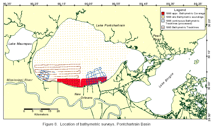
In 1996 and 1997, bathymetry was acquired in Lake Pontchartrain onboard the G. K. Gilbert during underway sediment sampling operations, discussed later. The transects were 0.75 mi apart and covered the entire lake. The data was acquired continuously and tied to DGPS every 10 s. The data are uncorrected for environmental parameters. At the same time, a separate water depth reading was acquired when the vessel slowed at each sediment sampling site. The following year, extensive bathymetric surveys were conducted along the southern shore of Lake Pontchartrain, from South Point to Bonnet Carré Spillway. The surveys focused on locating and defining the dredge pits along the south shore, as well as a high- resolution survey across the southern portion of the lake. The surveys were conducted from a 21-ft boat (University of New Orleans) as described below. Grid surveys covered the dredge pits with transects less than 0.5 km apart. The regional survey consisted of shore-perpendicular transects approximately 0.5 km apart with two or three shore-parallel tie-lines. The bathymetric surveys were conducted to establish a baseline bathymetry along sensitive areas of the southern shoreline and to monitor temporal change. Tentative grid sets of the two BCS surveys, uncorrected for environmental parameters, have been developed and compared for bathymetric change during discharge of Mississippi floodwaters via the Bonnet Carré Spillway in 1996. The data sets will also be compared to the two underway sediment sampling system data sets and to the National Oceanic and Atmospheric Administration (NOAA) Gulf Coast Low Water datum. The 1998 data set is currently being processed by researchers at the University of New Orleans and will provide a baseline grid for temporal change models. Methods Bathymetric surveys in 1995 were conducted onboard the G.K. Gilbert. The signal from two 200 kHz transducers located in the sea chest in the boat’s hull was received by an Innerspace 448 fathometer, which recorded about 20 readings a second. Navigation was recorded at about one fix per second from a Trimble GPS receiver using Geolink mapping software. The boat maintained a speed of 3 to 4 knots throughout the survey. Fathometer depth below waterline was corrected, but no corrections were made regarding tide, pitch, or roll. The bathymetry surveys conducted in 1996 and 1997 during the underway sediment sampling surveys were similar to the 1995 bathymetric survey, except a PLGR (Rockwell) DGPS receiver and Geolink software were used to acquire navigation. The 1997 bathymetric survey off the Bonnet Carré Spillway was a repeat survey of the 1995 survey lines. As with the 1998 survey, the data were acquired from a 21-ft fiberglass V-hull boat. Speed was maintained at about 4 knots. One E Sound 103 fathometer received a continuous signal from a 200 kHz transducer with a resolution of ±50 cm. Navigation was acquired every 2 s using a PLGR (Rockwell) DGPS receiver. Data was collected using a Fugawi software package. The 1995 and 1997 bathymetric data were initially processed and contoured using the commercial software package CPS-3. A FORTRAN program was designed to interpolate a navigational fix for soundings recorded in between received navigational fixes, and soundings with identical navigational fixes were averaged.
|
|||||||||||||||