
USGS Professional Paper 1634
|
| The following field investigations were conducted between 1994 and 1997 in Lakes Pontchartrain, Maurepas, Borgne and the surrounding waterways, excluding the Mississippi River. An outline of the survey techniques, their task objective, and accomplishments to date will be followed by detailed descriptions of the methods involved in the techniques. |
|
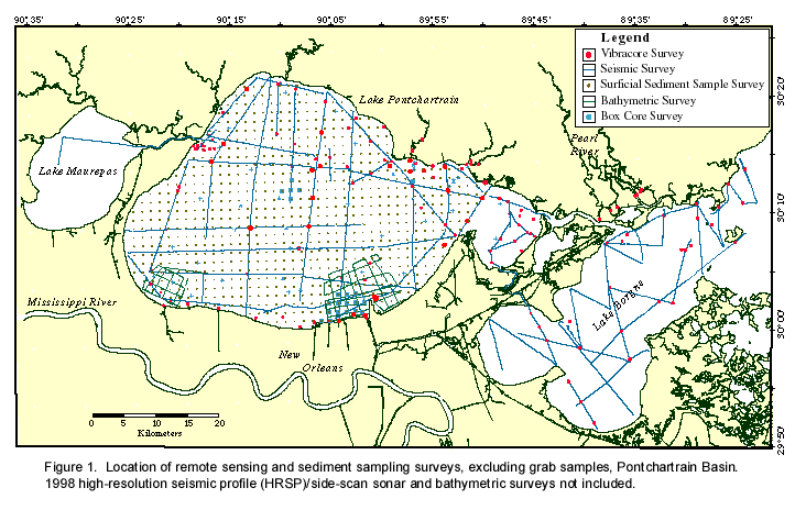
Table 1. Field investigations used in the Lake Pontchartrain Basin
study.
| Field Investigation | Technique | Task Objectives |
| Geophysical Surveys | ||
| Seismic
profiling (>650 line-km) |
Data interpretation for geologic framework; modeling | |
| Side-scan surveys | Geomorphology | |
| Bathymetric
surveys (3 surveys, >100 km) |
Geomorphology; Modeling temporal change |
|
| Sediment Sampling | Vibracores
(102) |
High resolution sedimentation patterns; post-Pleistocene geologic framework |
| Boreholes (>100) | Regional sedimentation patterns; Pleistocene geologic framework | |
| Box cores (>80) | Downcore geochronology; contaminant history; palynological studies | |
| Grab samples (>100) | Regional surficial contaminant survey | |
| Underway
surficial sediment sampling (2 surveys, 800 sites each) |
Regional surficial contaminant survey | |
| Others: Oceanographic and atmospheric flux and circulation measurements |
Wind measurements Current measurements Turbidity measurements Satellite imagery Tide gauge |
Circulation modeling; shoreline mapping |
Summary
To properly address the issues associated with sediment quality and shoreline dynamics of the Lake Pontchartrain Basin, it is necessary to understand the geologic evolution of the region as well as recent changes in the characteristics of the lake bottom and subsurface. To develop this understanding, a variety of field investigative techniques must be employed. Remote sensing provides a noninvasive, multi-dimensional survey of the lake bottom and subsurface that provides data for geologic framework interpretations, computer models of lake bottom and water column dynamics, and identification of features such as relic barriers, beach trends, fault lines and manmade structures. Subsurface sampling techniques such as vibracore, borehole drilling, and box cores provide a means to directly sample the sediments at depths and resolutions dependent on the type of investigation. Sediments obtained by these techniques yield information on Quaternary geologic framework, regional sedimentation patterns, downcore geochronology, palynology, and sediment contamination history. Finally, surficial sediment sampling such as grab samples and underway sampling are necessary to determine regional sedimentation and contaminant distribution and temporal changes in distribution during the length of the study.
References
Dunbar, J.B., Blaes, M.R., Dueitt, S.E., May, J.R., and Stroud, K.W., 1994, Geological investigation of the Mississippi River deltaic plain: U.S. Army Corps Technical Report GL-84-15; report 2 of a series.
Dunbar, J.B., Blaes, M.R., Dueitt, S.E., and May, J.R., 1995, Geological investigation of the Mississippi River deltaic plain: U.S. Army Corps Technical Report GL-84-15; report 3 of a series.
Flowers, G.C., and Isphording, W.C., 1990, Environmental sedimentology of the Pontchartrain Estuary: Gulf Coast Association of Geological Societies Transactions, v. 40, p. 237-250.
Johnson, H. P., and Helferty, M., 1990, The geological interpretation of side-scan sonar: Reviews of Geophysics, v. 28, no. 4, p. 357-380.
Kenwood, C.M., Manheim, F.T., Williams, S.J., and Polloni, C.F., 1996, An environmental and geological bibliography for Lake Pontchartrain: U.S. Geological Survey Open-File Report 96-527.
Landrum, K.E., 1994, Environmental sedimentology and trace-metal geochemistry of the Barataria Basin and St. Bernard Delta Estuaries, Louisiana: Draft report to the Louisiana Department of Environmental Quality, 101 p. plus appendices.
Manheim, F.T., Flowers, G.C., McIntire, A.G., Marot, M.E., and Holmes, C.W., 1997, Environmental geochemistry and sediment quality in Lake Pontchartrain: Database development and review: Gulf Coast Association of Geological Societies Transactions, v. 47, p. 337-349.
Tarver, J.W., and Savoie, L.B., 1976, An inventory and study of the Lake Pontchartrain-Lake Maurepas estuarine complex: Louisiana Wild Life and Fisheries Commission; Oyster, Water Bottoms and Seafoods Division, Technical Bulletin 10, 159 p.