| Lake Pontchartrain Basin: Bottom Sediments and Related Environmental Resources |
Figure 5. Map showing areas in "AREA_CODE" field.
Below is a map of the areas used in the AREA_CODE field of the database (appendix D), along with a table showing both the codes and the descriptions. Available here are compressed (.zip) files containing either MapInfo's export files or an ArcView shapefile showing these delineated areas. To obtain free utilities to decompress these files, see Tip 3 in appendix D.
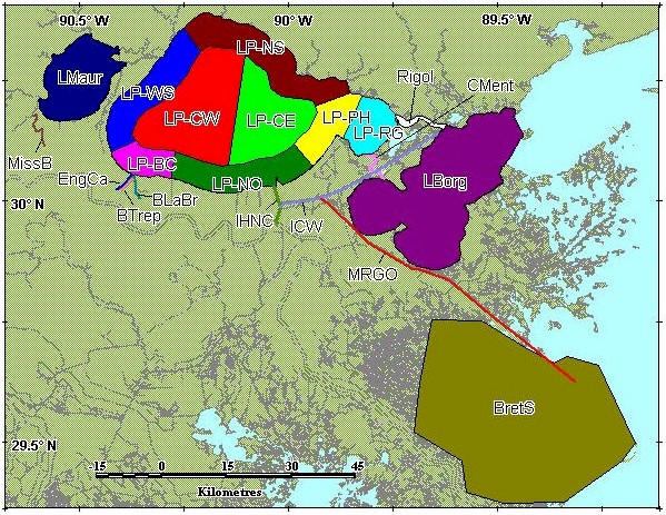
| AREA_CODE | AREA_DESCRIPTION |
| BLaBr | Bayou LaBranche |
| BretS | Breton Sound |
| BTrep | Bayou Trepagnier |
| CMent | Chef Menteur |
| EngCa | Engineers Canal |
| ICW | Intracoastal Waterway |
| IHNC | Inner Harbor Navigation Canal |
| LBorg | Lake Borgne |
| LMaur | Lake Maurepas |
| LP-BC | Lake Pontchartrain, Bonnet Carré region |
| LP-CE | Lake Pontchartrain, central region east of Causeway |
| LP-CW | Lake Pontchartrain, central region west of Causeway |
| LP-NO | Lake Pontchartrain, New Orleans region |
| LP-NS | Lake Pontchartrain, north shore region |
| LP-PH | Lake Pontchartrain, Pointe aux Herbes region |
| LP-RG | Lake Pontchartrain, Rigolets region |
| LP-WS | Lake Pontchartrain, west shore region |
| MissB | Mississippi Bayou |
| MRGO | Mississippi River Gulf Outlet |
| Rigol | Rigolets |
![]() Back to Data Sources and
Locations
Back to Data Sources and
Locations