
| Lake Pontchartrain Basin: Bottom Sediments and Related Environmental Resources |
Database Structure and Development (cont.)
Data Sources and Locations
The database in appendix D contains data from the sources and sponsoring agencies listed below in table 7. See table B4 for full references or source data.
Table 7. List of sediment data sources and sponsoring agencies.
| Source | Agency/Organization |
| Byrne and DeLeon, 1986 | University of New Orleans (UNO) / U.S. Army Corps of Engineers (USACE) |
| Byrne and DeLeon, 1987 | University of New Orleans (UNO) / Louisiana Department of Environmental Quality (LDEQ) |
| Childers, 1985 | Southeastern Louisiana University / Louisiana Department of Natural Resources- Coastal Zone Management Division (LDNR-CZMD) |
| Crocker, 1988 | University of New Orleans (UNO) |
| Demcheck and others, 1996 | U.S. Geological Survey (USGS) |
| Dunbar and others, 1995 | U.S. Army Corps of Engineers (USACE) |
| Ferrario and others, 1985 | University of New Orleans (UNO) / U.S. Army Corps of Engineers (USACE) |
| Flocks, 1998 | U.S. Geological Survey (USGS) |
| Flowers, G.C., 1987 (unpublished) | Tulane University Department of Geology |
| Landrum, 1994 (see also Landrum, 1995) | Louisiana Department of Environmental Quality (LDEQ) |
| LDEQ, 1989 | Louisiana Department of Environmental Quality- Office of Water Resources- Water Pollution Control Division (LDEQ-OWR-WPCD) |
| Macauley and Summers, 1998 | U.S. Environmental Protection Agency (USEPA) |
| Marot, M., and Holmes, C.W., in review | U.S. Geological Survey (USGS) |
| McFall and others, 1985 | University of New Orleans (UNO) / U.S. Army Corps of Engineers (USACE) |
| Roberts, 1981 | Louisiana State University (LSU) |
| Sarkar, 1995 | Tulane University Department of Geology |
| Schurtz and St. Pé, 1984 | Louisiana Department of Environmental Quality (LDEQ) |
| Sikora and Sikora, 1982 | U.S. Army Corps of Engineers (USACE) |
| Tarver and Dugas, 1973 | Louisiana Wildlife and Fisheries Commission |
| Tarver and Savoie, 1976 | Louisiana Wildlife and Fisheries Commission |
| Voyksner, 1985 | Louisiana Department of Environmental Quality (LDEQ) |
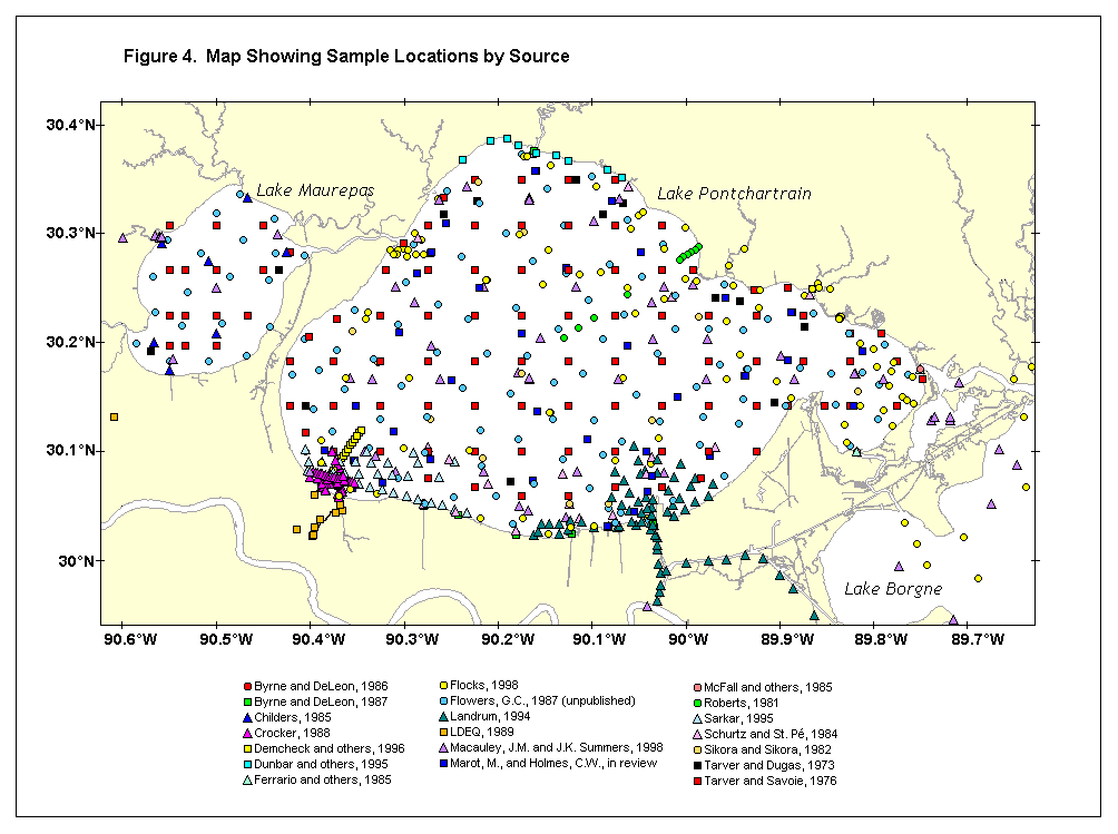
| Figure 4 gives the locations of sediment samples from the sources in the database (appendixes C and D). A few additional sources were identified in library searches but have not been entered into the database because of limited contributions to existing information or special problems like insufficient location data. | (click on image for a larger view) |
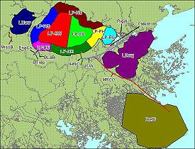
| The area code index map (fig. 5) provides geographical names for specific parts of Lake Pontchartrain and other waterways. | (click on image for a larger view, code descriptions, and
opportunity to download GIS layer) |
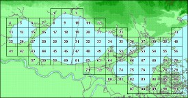
| A numerical index grid (fig. 6) is included in the database (appendixes C and D) for analysis purposes. This index provides a convenient way to search on data from specific localities covered by the database. Sorting of the sediment data in spreadsheet form by grid number and specific chemical parameters has been used to compare group data from independent sources for specific local areas as a part of data quality screening. Indexing may be helpful when the presently available sediment data are combined with other information, such as biological data or toxicity measurements. | (click on image for a larger view and opportunity to
download GIS layer) |
| Forward to Analytical
Methods and QC |
|
Table of Contents: Sediment Database and Geochemical Assessment |
|