| Lake Pontchartrain
Basin: Bottom Sediments and Related Environmental Resources |
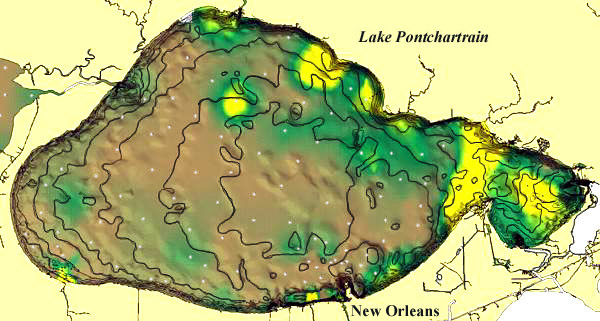
Figure 12. Grain size distribution draped over bathymetry, Lake Pontchartrain.
| Sand content is shown in colors with bathymetry overlaid in shading
and contour lines. The contour interval is 0.5 m, and a maximum depth of
4. 5 m occurs in the
middle of Lake Pontchartrain as well as in dredged areas near the New Orleans shore. Sand
content (2.0 to 0 .16 mm grain diameter) shows maximum concentrations in the narrow entry
channel to the east (Rigolets) and in trends in the northern and
eastern part of Lake Pontchartrain.
Local increases of coarse sediments also occur in nearshore areas adjacent to the Bonnet
Carré Spillway. Note that the percentage of "sand and gravel" based on
size analysis is influenced by the presence of clam shells (Rangia). The earlier
extensive dredging of the lakes for shell recovery means that dredged samples will be
finer grained than sediments that have never been dredged. |
 |
30.4°N |
| 30.0°N |
| 90.45°W |
|
89.72°W |
 Back to Sediment Texture and Bathymetry
 |