
| Lake Pontchartrain Basin: Bottom Sediments and Related Environmental Resources |
SUMMARY OF GEOLOGICAL AND CHEMICAL DATA
Sediment Texture and Bathymetry
| Grain
size distribution draped over bathymetry 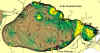 Figure 12 |
Grain
size distribution in New Orleans shore area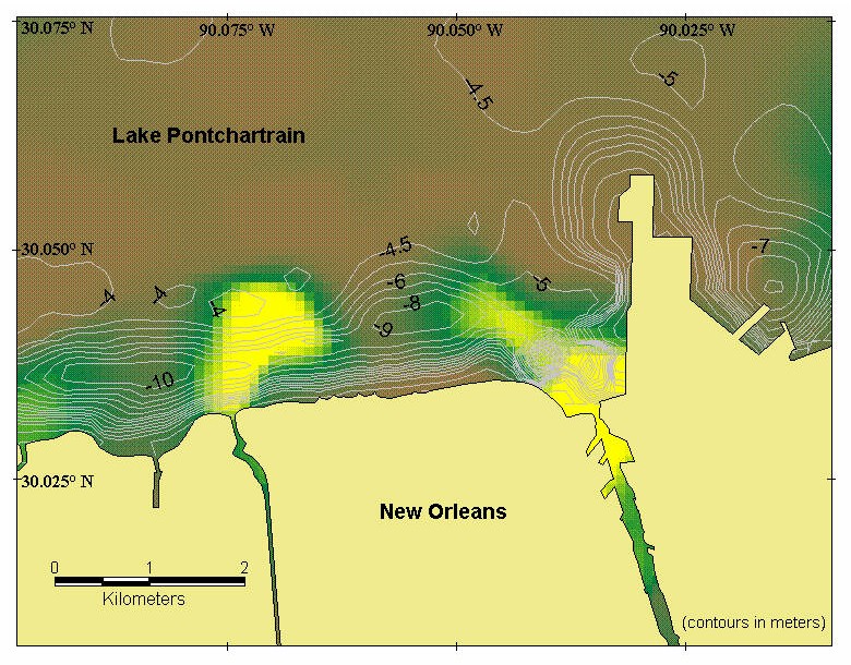 Figure 13 |
Physiography in the
vicinity of New Orleans, circa 1750 A.D.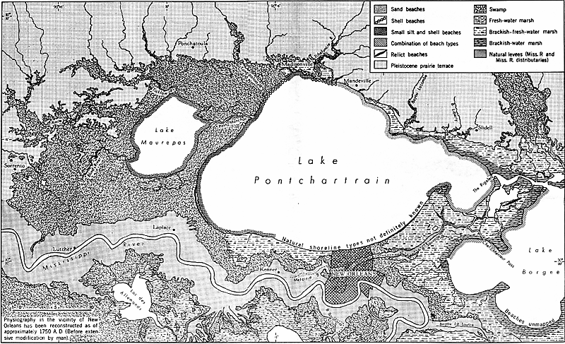 Figure 14 |
Lakes Pontchartrain and Maurepas are shallow. Maximum depth of about 5 m occurs in the middle of Lake Pontchartrain (figure 12) and localized pits near the New Orleans shore are up to 10 m in depth (fig. 13). The percentage of sand (defined as the grain size fraction between 2.0 and 0.16 mm diameter) compiled from all quantitative and specifically located sources (except recent EMAP data, Macauley and Summers, 1998) is depicted in color gradations in figures 12 and 13. Significant sand fractions are found only in trends in the northern and eastern part of Lake Pontchartrain. High concentrations of coarse sediments also occur in small, nearshore areas adjacent to the Bonnet Carré Spillway. In the remainder of the lake bottom, the sand content is usually less than 10%.
As pointed out by Flowers and Isphording (1990), Lake Pontchartrain and Maurepas sediments have the finest grain sizes of all major Gulf of Mexico estuaries. The reason for this fineness may be seen in the classical delineation of pre-European settlement environments surrounding the lake (Saucier, 1994; fig. 14). Much of the shoreline is swampy lowlands, which limit influx of coarser sediments. Strong currents through the narrow Rigolets channel transport a small amount of coarse material. A much larger amount of material of sand fraction size has been transported historically through "crevasses" or breakthrough channels from the Mississippi River during floods and high stages, as noted in the section on the Bonnet Carré Spillway. However, most of the coarse fraction is dropped within a few kilometers of the entry channel, leaving mostly silts and clay to be transported farther into the lake (Crocker, 1988).
Dredging effects
It should be noted that the texture distribution as shown in figure 12 (based on the data in appendix D) refers to surface sediments. These sediments were recovered mainly by Ponar and similar grab samplers and average about 5 cm thick per sample. Subsequent to the previous publication (Manheim, Hayes, and McIntire, 1998), a set of data from piston cores have been included (M.E. Marot, written commun., 1999). In undredged (undisturbed) areas, significant concentrations of Rangia clams make up most of the coarse fraction. A large part of the lake bottom, estimated at about two-thirds, has been dredged at various times in the past, until prohibition of dredging in 1990 (USACE, 1987). The sediment texture shown in figure 12 is, thus, influenced both by removal of most of the clam-shell debris in dredged sites and by mixing of deeper and surface layers down to a depth of 1 m or more. In a large part of the lake, disturbed surficial sediments may be similar in texture to naturally occurring sediments. However, in the isolated high-sand anomalies in figure 12 and perhaps other areas, dredging operations of 1 m or more may have mixed sands from buried deposits into surficial sediments.
The relict sand bodies have been covered by fine lacustrine/estuarine sediments, as shown by earlier USACE borings along the causeway (Dunbar, 1995). Fine sediment surficial layers are also confirmed by the more recent vibracores (>Kindinger, this volume; Flocks, this volume). However, in some areas the sand trends may come close enough to the surface to be reached during dredging operations. It should be noted that dredged areas are surrounded by a halo of fine-grained materials that become thinner with distance. The dredged deposits are themselves overlain by very recent fine sediments, whose thickness depends on the time since dredging. The texture map in figure 12, created by triangulation gridding of available sediment samples, thus depicts a combination of naturally occurring sediments and the results of human disturbance.
Modeling predictions: Expectations for sediment distributions are complicated by pre-existing structures
Modeling of wind- and tide-driven waves and currents suggests that coarser sediments like sands would be distributed around the periphery of Lake Pontchartrain (Signell and others, this volume). However, the constraints on sediments delivered to the lake strongly limit the input and availability of sands. The prevalence of sand in the northern and eastern parts of the lake, therefore, appears to be due to the occurrence of older barrier bars and beaches, exemplified by the Milton Island and Pine Island trends (Penland and others, 1988; Flowers and Isphording, 1990; Saucier, 1994). As indicated in the previous paragraphs on dredging effects, these relict sands were probably brought to the surface through clam-shell dredging operations, where they could be recovered by grab samplers.
| Forward to Organic
Carbon |
|
Table of Contents: Sediment Database and Geochemical Assessment |
|