 |
| Professional Paper 1643: FIGURE 31 |
Figure 31
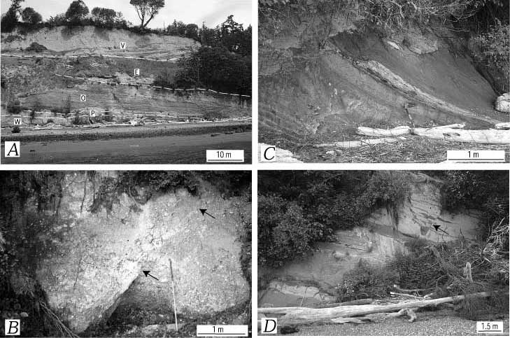
Deformation of upper Pleistocene strata at Strawberry Point. A, Gently dipping (shown by white dashed lines) Possession Drift (P) on the north flank of a gentle anticline exposed south of fault 1 at i, Strawberry Point (figure 27). Interbedded sand and mud at the base of the bluff are assigned to the Whidbey Formation (W); organic matter in these beds yielded an infinite radiocarbon date ( table 2, figure 27). These strata are overlain by a thin diamict assigned to the Possession Drift (P), in turn overlain by mud, sand, and gravel assigned to the nonglacial Olympia beds (O). Detrital peat at the base of the Olympia at this locality yielded a date of 37,190± 550 14C yr B.P. The Olympia is overlain by Esperance Sand Member (E) and main body of Vashon Drift (V). B, Gravel and sand assigned to the Possession Drift cut by a thrust fault (arrows) with displacement of 1-2 m, approximately 40 m south of m (figure 27). C, Whidbey Formation strata dipping ≈45° NW., locality m on Strawberry Point. Beds consist of mud, sand, and woody peat (white-weathering bed above shovel). Peat at this locality yielded an infinite radiocarbon date. Shovel handle is divided into 10 cm increments. D, Exposure of Whidbey(?) Formation sand and mud at locality o on Strawberry Point (figure 27). Beds strike north, dip 28° W., and are cut by subvertical fractures (see arrow in upper right). E, Exposure of highly fractured friable sand of the Whidbey(?) Formation at locality p on Strawberry Point (figure 27). Box shows approximate location of F. F, Close-up of outcrop at p (see E), showing highly fractured friable sand.
NEXT: Figure 31 E,F
Use BACK button to return
Contact: Susan Rhea
This page is brought to you by the Earthquake Hazards Program
