
The New Hampshire Bedrock Aquifer Assessment was designed to provide information that can be used by communities, industry, professional consultants, and other interests to evaluate the ground-water development potential of the fractured-bedrock aquifer in the State. The assessment was done at statewide, regional, and well field scales to identify relations that potentially could increase the success in locating high-yield water supplies in the fractured-bedrock aquifer. statewide, data were collected for well construction and yield information, bedrock lithology, surficial geology, lineaments, topography, and various derivatives of these basic data sets. Regionally, geologic, fracture, and lineament data were collected for the Pinardville and Windham quadrangles in New Hampshire. The regional scale of the study examined the degree to which predictive well-yield relations, developed as part of the statewide reconnaissance investigation, could be improved by use of quadrangle-scale geologic mapping.
Beginning in 1984, water-well contractors in the State were required to report detailed information on newly constructed wells to the New Hampshire Department of Environmental Services (NHDES). The reports contain basic data on well construction, including six characteristics used in this study—well yield, well depth, well use, method of construction, date drilled, and depth to bedrock (or length of casing). The NHDES has determined accurate georeferenced locations for more than 20,000 wells reported since 1984. The availability of this large data set provided an opportunity for a statistical analysis of bedrock-well yields. Well yields in the database ranged from zero to greater than 500 gallons per minute (gal/min).
Multivariate regression was used as the primary statistical method of analysis because it is the most efficient tool for predicting a single variable with many potentially independent variables. The dependent variable that was explored in this study was the natural logarithm (ln) of the reported well yield. One complication with using well yield as a dependent variable is that yield also is a function of demand. An innovative statistical technique that involves the use of instrumental variables was implemented to compensate for the effect of demand on well yield.
Results of the multivariate-regression model show that a variety of factors are either positively or negatively related to well yields. Using instrumental variables, well depth is positively related to total well yield. Other factors that were found to be positively related to well yield include (1) distance to the nearest waterbody; (2) size of the drainage area upgradient of a well; (3) well location in swales or valley bottoms in the Massabesic Gneiss Complex and Breakfast Hill Granite; (4) well proximity to lineaments, identified using high-altitude (1:80,000-scale) aerial photography, which are correlated with the primary fracture direction (regional analysis); (5) use of a cable tool rig for well drilling; and (6) wells drilled for commercial or public supply. Factors negatively related to well yields include sites underlain by foliated plutons, sites on steep slopes sites at high elevations, and sites on hilltops. Additionally, seven detailed geologic map units, identified during the detailed geologic mapping of the Pinardville and Windham quadrangles, were found to be positively or negatively related to well yields. Twenty-four geologic map units, depicted on the Bedrock Geologic Map of New Hampshire, also were found to be positively or negatively related to well yields.
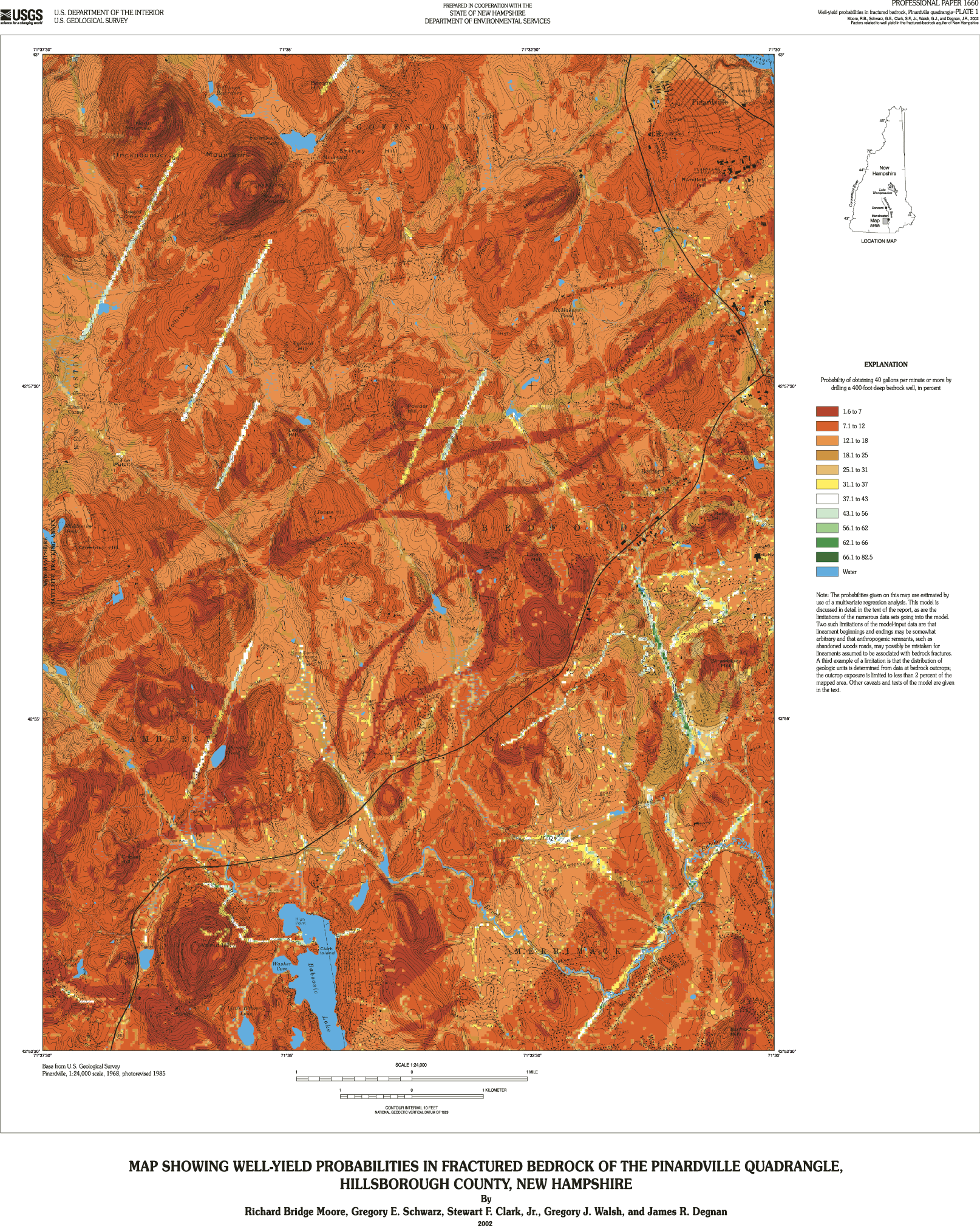
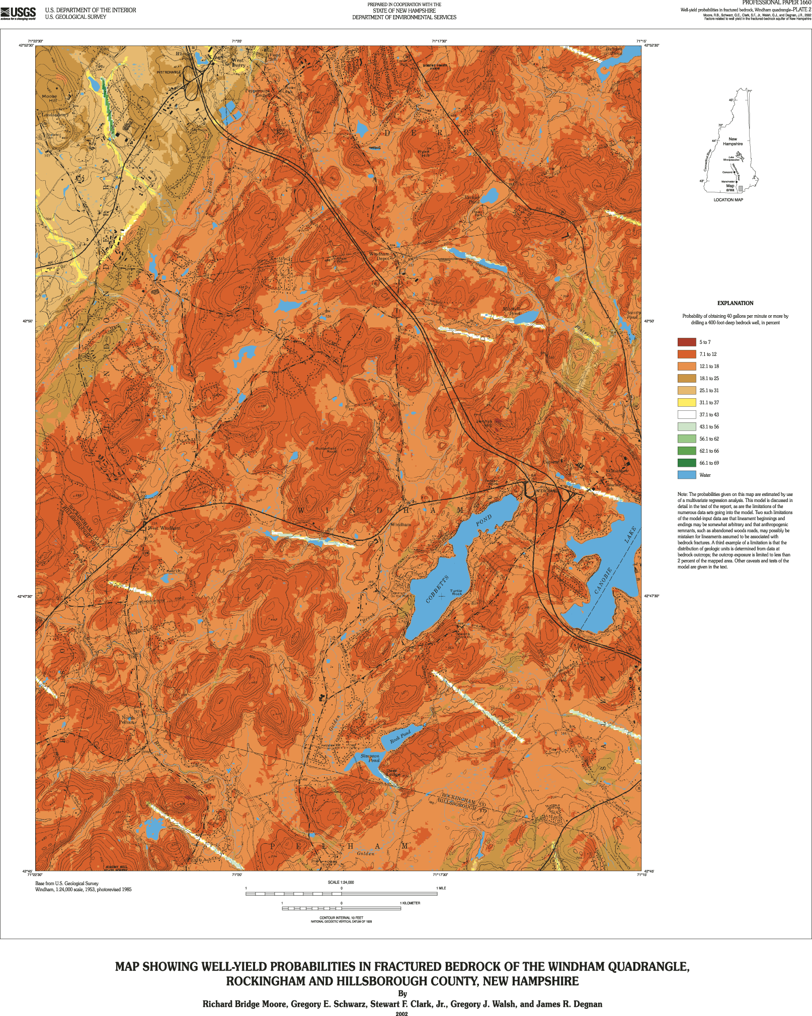
Maps or geographic information system (GIS) data sets identifying areas of various yield probabilities clearly display model results. Probability criteria developed in this investigation can be used to select areas where other techniques, such as geophysical techniques, can be applied to more closely identify potential drilling sites for high-yielding (greater than 40 gal/min) bedrock wells.
To measure the added value of field-based methods for well-yield-probability forecasting, the model was run with and without the variables developed from the detailed geologic mapping for the Pinardville and Windham quadrangles. Four probability maps were produced for the two quadrangles, one with and one without the added variables. These maps clearly demonstrate the advantage of detailed geologic mapping when prospecting for new ground-water supplies in the fractured-bedrock aquifer of New Hampshire.
Abstract
Introduction
Purpose and Scope
Previous Investigations
Acknowledgments
Hydrogeologic Setting
Methods and Approach
Descriptions and Sources of Data
Well Information
Bedrock Lithology
Lineaments
Surficial Material
Topographic Settings and Characteristics
Additional Variables Investigated at the Quadrangle Scale
Creation of a Verification Data Set
Development of the Statewide Regression Model
Factors Related to Well Yield
Regression Model Equation
Regression Model Testing
Yield-Probability Forecasting
Maps of Yield Probability
Comparison of Regional Variables with Statewide Variables
Summary and Conclusions
Selected References
Appendix A. Regression Model Construction
Appendix B. List of Variables Tested for the Regression Model
Reference Cited
Appendix C. Regression Model Tests
Test for an Endogenous Variable
Specification Test
Residual Statistical Distribution
Residual Spatial Distribution and Spatial Analysis
Comparison of Verification and Primary Data Sets
Finite Bias Test
Overall Statement
References Cited
The text and graphics are presented here in pdf format (print quality):
The full report is 5MB
For faster downloading of this report:
If you have Adobe Acrobat Reader installed on your computer, you may view and/or print the PDF version of this report. If you do not have Acrobat Reader, you may download it here.
For more information about USGS activities in New Hampshire, visit the USGS New Hampshire District home page.
| AccessibilityFOIAPrivacyPolicies and Notices | |
| |
|