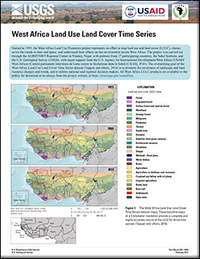
West Africa land use and land cover time series
Links
- Documents:
- Data Release: USGS data release - West Africa Land Use Land Cover Time Series
- Download citation as: RIS | Dublin Core
Abstract
Started in 1999, the West Africa Land Use Dynamics project represents an effort to map land use and land cover, characterize the trends in time and space, and understand their effects on the environment across West Africa. The outcome of the West Africa Land Use Dynamics project is the production of a three-time period (1975, 2000, and 2013) land use and land cover dataset for the Sub-Saharan region of West Africa, including the Cabo Verde archipelago. The West Africa Land Use Land Cover Time Series dataset offers a unique basis for characterizing and analyzing land changes across the region, systematically and at an unprecedented level of detail.
Suggested Citation
Cotillon, S.E., 2017, West Africa land use and land cover time series: U.S. Geological Survey Fact Sheet 2017–3004, 4 p., https://doi.org/10.3133/fs20173004.
ISSN: 2327-6932 (online)
Study Area
Table of Contents
- The West Africa Land Use Land Cover Time Series—1975, 2000, and 2013
- Approach to Mapping Land Use and Land Cover Through Time
- Main Trends of Land Cover Change
- Land Cover Applications
- References Cited
| Publication type | Report |
|---|---|
| Publication Subtype | USGS Numbered Series |
| Title | West Africa land use and land cover time series |
| Series title | Fact Sheet |
| Series number | 2017-3004 |
| DOI | 10.3133/fs20173004 |
| Publication Date | February 16, 2017 |
| Year Published | 2017 |
| Language | English, French |
| Publisher | U.S. Geological Survey |
| Publisher location | Reston, VA |
| Contributing office(s) | Earth Resources Observation and Science (EROS) Center |
| Description | Report: 4 p.; Data release |
| First page | 1 |
| Last page | 4 |
| Country | Benin, Burkina Faso, Chad, Cote d'Ivoire, The Gambia, Guinea, Guinea Bissau, Liberia, Mali, Mauritania, Niger, Nigeria, Senegal, Sierra Leone, Togo |
| Other Geospatial | West Africa |
| Online Only (Y/N) | Y |


