Assessment of Coalbed Gas Resources in the Raton Basin-Sierra Grande Uplift Province, Colorado and New Mexico, 2022
Links
- Document: Report (1.50 MB pdf) , HTML , XML
- Data Release: USGS data release - USGS National and Global Oil and Gas Assessment Project—Raton Basin-Sierra Grande Uplift Province: Assessment Unit Boundaries, Assessment Input Data, and Fact Sheet Data Tables
- Download citation as: RIS | Dublin Core
Abstract
Using a geology-based assessment methodology, the U.S. Geological Survey estimated a mean of 5.2 trillion cubic feet of coalbed gas in the Vermejo Formation and Raton Formation of the Raton Basin-Sierra Grande Uplift Province.
Introduction
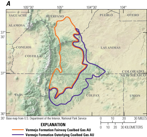
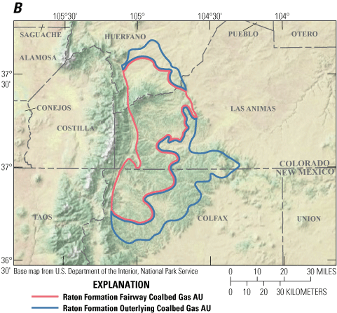
The U.S. Geological Survey (USGS) assessed the potential for coalbed gas resources in the Vermejo and Raton Formations in the Raton Basin-Sierra Grande Uplift Province of Colorado and New Mexico (fig. 1A and B). In the early 1990s a major pipeline and associated infrastructure became available in the Raton Basin, which led to the drilling of more than 4,300 coalbed gas wells (Osterhout and others, 2015). These wells clearly defined the most productive coalbed gas producing areas or fairways of the basin (Flores and others, 1985; Higley, 2007; Osterhout and others, 2015). The purpose of this report is to present the assessment results of the remaining potential for coalbed gas resources in fairways and outlying coal-bearing areas of the Vermejo and Raton Formations following an evaluation of available geologic and production data.


Maps showing location of four coalbed gas assessment units (AUs) in the Raton Basin-Sierra Grande Uplift Province of Colorado and New Mexico. A, Vermejo Formation coalbed gas AUs, B, Raton Formation coalbed gas AUs.
The present tectonic configuration of the Raton Basin is an intermontane basin, a consequence of latest Cretaceous–Paleogene Laramide contractional deformation (Higley, 2007). Prior to Laramide deformation, the Raton Basin was part of the Sevier foreland basin and was situated along the eastern part of the Cretaceous Western Interior Seaway (Tremain, 1980). The Vermejo and Raton Formations are included within two tectonostratigraphic units that span the tectonic transition from the Jurassic–Cretaceous Sevier foreland basin to the Late Cretaceous–Paleogene Laramide intermontane Raton Basin. The Vermejo Formation and the underlying Trinidad Sandstone represent a prograding wave-dominated deltaic and barrier system developed along the eastern side of the Western Interior Seaway (Flores and others, 1985; Tyler and others, 1995). The Vermejo Formation represents back-barrier peat swamps and delta-plain fluvial systems associated with deltaic and barrier systems of the Trinidad Sandstone (Flores and others, 1985). Coal beds in the Vermejo Formation are mainly back-barrier delta-plain deposits with good lateral continuity parallel to the coastline (Carlton, 2006). Beginning in the Maastrichtian, Laramide contractional deformation led to uplift, erosion, and the formation of an unconformity at the top of the Vermejo Formation, although the unconformity is not recognized regionally. The basal unit of the Raton Formation is a laterally discontinuous conglomerate of a regional eastward flowing fluvial system representing the initial pulse of orogenic clastics related to Laramide deformation. The basal conglomerate was followed by a fluvial system with proximal coarse-grained low-sinuousity channels systems of the Poison Canyon Formation that graded downdip to high-sinuousity channel systems with extensive floodplains of the Raton Formation (Flores and others, 1985). Interdistributary peat swamps associated with high-sinuosity fluvial channel systems resulted in the deposition of coal beds with less lateral continuity than the coals of the Vermejo Formation (Jurich and Adams, 1984; Carlton, 2006).
Total Petroleum System and Assessment Units
The USGS defined the Upper Paleozoic–Cenozoic Total Petroleum System (TPS) that includes the Vermejo Formation Fairway Coalbed Gas Assessment Unit (AU), Vermejo Formation Outerlying Coalbed Gas AU, the Raton Formation Fairway Coalbed Gas AU, and the Raton Formation Outerlying Coalbed Gas AU (fig. 1A and B). The Vermejo Formation Fairway Coalbed Gas AU and the Raton Formation Fairway Coalbed Gas AU are those areas with greater than 20-foot net coal thickness (Tyler and others, 1995), and by the Sangre de Cristo thrust belt that defines the western basin margin. The Vermejo Formation Outerlying Coalbed Gas AU and the Raton Formation Outerlying Coalbed Gas AU are those areas with less than 20-foot net coal thickness (Tyler and others, 1995), and by the boundary defined as the “0” gas presence line (Seidel, 2002). The 0 gas line closely approximates the outcrop belt of the Trinidad Sandstone (Hoffman and Brister, 2003).
The Vermejo Formation Fairway AU and the Vermejo Formation Outerlying AU include coals of the Vermejo Formation and Cretaceous coals in the lower part of the Raton Formation. The Raton Formation Fairway AU and Raton Formation Outerlying AU contain coals within the upper part of the Raton Formation. All four AUs include the possibility for gas that could be produced from adjacent fluvial channel sandstones along with coalbed gas, given the standard vertical well perforation and hydraulic fracturing processes commonly employed in the coalbed gas wells in the Raton Basin (Woodward, 1983; Hoffman and Brister, 2003; Carlton, 2006; Higley, 2007). The assessment also includes the possibility of gas sourced from fractured organic-rich shales, including gas from the Graneros Shale, Niobrara Formation, and the Sharon Springs Member of the Pierre Shale (Woodward, 1997) that might have migrated vertically and augmented the gas content of Vermejo Formation and Raton Formation coals. The assessment input data for four coalbed gas AUs are summarized in table 1 and in Schenk (2023).
Table 1.
Key input data for four coalbed gas AUs in the Raton Basin-Sierra Grande Uplift Province of Colorado and New Mexico.[The average EUR input is the minimum, median, maximum, and calculated mean. Gray shading indicates not applicable. AU, assessment unit; %, percent; EUR, estimated ultimate recovery; MMBO, million barrels of oil; BCFG, billion cubic feet of gas]
Undiscovered Resources Summary
The USGS quantitatively assessed remaining coalbed gas resources within four continuous assessment units in the Raton Basin-Sierra Grande Uplift Province (table 2). The estimated mean for coalbed gas resources is 5,210 billion cubic feet of gas (BCFG), or 5.2 trillion cubic feet of gas, with an F95–F5 range from 1,560 to 9,253 BCFG.
Table 2.
Results for four continuous coalbed gas assessment units in the Raton Basin-Sierra Grande Uplift Province.[Results shown are fully risked estimates. F95 represents a 95-percent chance of at least the amount tabulated; other fractiles are defined similarly. Gray shading indicates not applicable. MMBO, million barrels of oil; BCFG, billion cubic feet of gas; NGL, natural gas liquids; MMBNGL, million barrels of natural gas liquids]
For More Information
Assessment results are also available at the USGS Energy website, https://www.usgs.gov/energy-and-minerals/energy-resources-program/.
Raton Basin-Sierra Grande Uplift Province Assessment Team
Christopher J. Schenk, Thomas M. Finn, Tracey J. Mercier, Cheryl A. Woodall, Phuong A. Le, Andrea D. Cicero, Ronald M. Drake II, Geoffrey S. Ellis, Michael H. Gardner, Sarah E. Gelman, Jane S. Hearon, Benjamin G. Johnson, Jenny H. Lagesse, Heidi M. Leathers-Miller, Kristen R. Marra, Kira K. Timm, and Scott S. Young.
References Cited
Carlton, D.R., 2006, Discovery and development of a giant coalbed methane resource, Raton Basin, Las Animas County, southeast Colorado: The Mountain Geologist, v. 43, no. 3, p. 231–236, accessed October 17, 2022, at https://archives.datapages.com/data/rmag/GasAbs2006/Carlton.htm.
Flores, R.M., Pilmore, C.L., and Merewether, E.A., 1985, Overview of depositional systems and energy potential of Raton Basin, Colorado and New Mexico in Macke, D.L., and Maughan, E.K., eds., Many ways to future plays—Rocky Mountain section field trip guide 1985: American Association of Petroleum Geologists, Society of Economic Paleontologists and Mineralogists, and National Energy Minerals Division, p. 41–74, accessed October 17, 2022, at https://archives-datapages-com.usgslibrary.idm.oclc.org/data/rocky_sepm/data/013/013001/41_rocky_mount130041.htm.
Higley, D.K., 2007, Petroleum systems and assessment of undiscovered oil and gas in the Raton Basin-Sierra Grande Uplift Province, Colorado and New Mexico, chap. 2 of Higley, D.K., compiler, Petroleum systems and assessment of undiscovered oil and gas in the Raton Basin–Sierra Grande Uplift Province, Colorado and New Mexico—USGS Province 41: U.S. Geological Survey Digital Data Series DDS–69–N, 124 p., accessed October 17, 2022, at https://pubs.usgs.gov/dds/dds-069/dds-069-n/chapters.html.
Hoffman, G.K., and Brister, B.S., 2003, New Mexico’s Raton Basin coalbed methane play: New Mexico Geology, v. 25, no. 4, p. 95–110, accessed October 17, 2022, at https://geoinfo.nmt.edu/publications/periodicals/nmg/25/n4/nmg_v25_n4_p95.pdf.
Jurich, D., and Adams, M.A., 1984, Geologic overview, coal, and coalbed methane resources of the Raton Mesa Region–Colorado and New Mexico, in Coalbed methane resources of the United States—American Association of Petroleum Geologists Special Volume—Studies in Geology Series, v. 17, p. 163–184, accessed October 17, 2022, at https://doi.org/10.1306/St17437C7.
Osterhout, S.L., Rothkopf, B.W., and Soetrisno, H., 2015, Raton Basin–Raton Basin coal bed methane gas field, Colorado and New Mexico: Oil and Gas Fields of Colorado–2014, Rocky Mountain Association of Geologists, p. 267–292, accessed October 17, 2022, at https://archives-datapages-com.usgslibrary.idm.oclc.org/data/rocky-mtn-geologist-pubs/data/006/006001/267_rmag-bk0060267.htm?q=%2BtitleStrip%3Araton+% 2BauthorStrip%3Aosterhout+-isMeetingAbstract%3Amtgabsyes.
Schenk, C.J., 2023, USGS National and Global Oil and Gas Assessment Project—Raton Basin-Sierra Grande Uplift Province assessment unit boundaries, assessment input tables, and fact sheet data tables: U.S Geological Survey data release, https://doi.org/10.5066/P96I4K6F.
Tremain, C.M., 1980, The coalbed methane potential of the Raton Mesa coal region, Raton Basin, Colorado: Colorado Geological Survey Open–File Report 80–4, 48 p., accessed October 17, 2022, at https://coloradogeologicalsurvey.org/publications/coal-bed-methane-potential-raton-basin-colorado.
Tyler, R., Kaiser, W.R., Scott, A.R., Hamilton, D.S., and Ambrose, W.A., 1995, Geologic and hydrologic assessment of natural gas from coal—Greater Green River, Piceance, Powder River, and Raton Basins, western United States: Bureau of Economic Geology, University of Texas at Austin, Report of Investigations No. 228, 219 p., accessed October 17, 2022, at https://store.beg.utexas.edu/reports-of-investigations/2056-ri0228.html.
Woodward, L.A., 1983, Geology and hydrocarbon potential of the Raton Basin, New Mexico, in Oil and Gas Fields of the Four Corners Area, Volume III: Four Corners Geological Society, p. 789–798, accessed October 17, 2022, at https://archives-datapages-com.usgslibrary.idm.oclc.org/data/fcgs/data/016/016001/789_four-corners160789.htm?q=%2BtitleStrip%3Araton+%2BauthorStrip%3A woodward+-isMeetingAbstract%3Amtgabsyes.
Woodward, L.A., 1997, Role of regional tectonic analysis in exploration for fractured reservoirs in Cretaceous source rocks of the Raton Basin, New Mexico: The Mountain Geologist, v. 34, no. 2, p.73–80, accessed October 17, 2022, at https://archives-datapages-com.usgslibrary.idm.oclc.org/data/rmag/mg/1997/woodward.htm?q=%2BtitleStrip%3Araton+%2BauthorStrip%3Awoodward+-isMeetingAbs tract%3Amtgabsyes.
Disclaimers
Any use of trade, firm, or product names is for descriptive purposes only and does not imply endorsement by the U.S. Government.
Although this information product, for the most part, is in the public domain, it also may contain copyrighted materials as noted in the text. Permission to reproduce copyrighted items must be secured from the copyright owner.
Suggested Citation
Schenk, C.J., Finn, T.M., Mercier, T.J., Woodall, C.A., Le, P.A., Cicero, A.D., Drake, R.M., II, Ellis, G.S., Gardner, M.H., Gelman, S.E., Hearon, J.S., Johnson, B.G., Lagesse, J.H., Leathers-Miller, H.M., Marra, K.R., Timm, K.K., and Young, S.S., 2023, Assessment of coalbed gas resources in the Raton Basin-Sierra Grande Uplift Province, Colorado and New Mexico, 2022: U.S. Geological Survey Fact Sheet 2023–3020, 4 p., https://doi.org/10.3133/fs20233020.
ISSN: 2327-6932 (online)
Study Area
| Publication type | Report |
|---|---|
| Publication Subtype | USGS Numbered Series |
| Title | Assessment of coalbed gas resources in the Raton Basin-Sierra Grande Uplift Province, Colorado and New Mexico, 2022 |
| Series title | Fact Sheet |
| Series number | 2023-3020 |
| DOI | 10.3133/fs20233020 |
| Publication Date | July 06, 2023 |
| Year Published | 2023 |
| Language | English |
| Publisher | U.S. Geological Survey |
| Publisher location | Reston, VA |
| Contributing office(s) | Central Energy Resources Science Center |
| Description | Report: 4 p.; Data Release |
| Country | United States |
| State | Colorado, New Mexico |
| Other Geospatial | Raton Basin-Sierra Grande Uplift Province |
| Online Only (Y/N) | Y |


