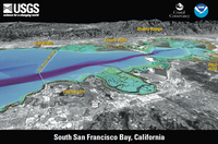
South San Francisco Bay, California
Links
- More information: USGS Index Page (html)
- Document: Report
- Download citation as: RIS | Dublin Core
Abstract
The U.S. Geological Survey, in cooperation with the California Coastal Conservancy and the National Oceanic and Atmospheric Administration, mapped the floor of south San Francisco Bay and adjoining land using single-beam sonar and airborne lidar (light detection and ranging). To learn more, visit http://pubs.usgs.gov/sim/2007/2987/.
View eastward. Elevations in mapped area color coded: purple (approx 15 m below sea level) to red-orange (approx 90 m above sea level). South San Francisco Bay is very shallow, with a mean water depth of 2.7 m (8.9 ft). Trapezoidal depression near San Mateo Bridge is where sediment has been extracted for use in cement production and as bay fill. Land from USGS digital orthophotographs (DOQs) overlaid on USGS digital elevation models (DEMs). Distance across bottom of image approx 11 km (7 mi); vertical exaggeration 1.5X.
Suggested Citation
Dartnell, P., Gibbons, H., 2007, South San Francisco Bay, California (Version 1.0): U.S. Geological Survey General Information Product 57, Postcard: 2 p., https://doi.org/10.3133/gip57.
ISSN: 2332-354X (online)
ISSN: 2332-3531 (print)
Study Area
| Publication type | Report |
|---|---|
| Publication Subtype | USGS Numbered Series |
| Title | South San Francisco Bay, California |
| Series title | General Information Product |
| Series number | 57 |
| DOI | 10.3133/gip57 |
| Edition | Version 1.0 |
| Year Published | 2007 |
| Language | English |
| Publisher | U.S. Geological Survey |
| Publisher location | Reston, VA |
| Contributing office(s) | Coastal and Marine Geology Program, San Francisco Bay-Delta |
| Description | Postcard: 2 p. |
| Country | United States |
| State | California |
| Other Geospatial | San Francisco Bay |
| Online Only (Y/N) | N |
| Additional Online Files (Y/N) | N |


