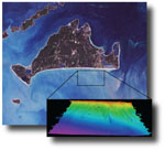
The U.S. Geological Survey Woods Hole Science Center conducted a nearshore geophysical survey offshore of the southern coast of Martha's Vineyard, in the vicinity of the Martha's Vineyard Coastal Observatory in 2007. This mapping program was part of a larger research effort supporting the Office of Naval Research Ripples Directed-Research Initiative studies at Martha's Vineyard Coastal Observatory designed to improve our understanding of coastal sediment-transport processes. The survey was conducted aboard the Megan T. Miller August 9-13, 2007. The study area covers 35 square kilometers from about 0.2 kilometers to 5 kilometers offshore of the south shore of Martha's Vineyard, and ranges in depth from ~6 to 24 meters. The geophysical mapping utilized the following suite of high-resolution instrumentation to map the surficial sediment distribution, bathymetry, and sub-surface geology: a dual-frequency 100/500 kilohertz sidescan-sonar system, 234 kilohertz interferometric sonar, and 500 hertz -12 kilohertz chirp subbottom profiler. These geophysical data will be used to provide initial conditions for wave and circulation modeling within the study area.


