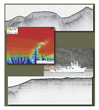
Chirp seismic-reflection data from the Baltimore, Washington, and Norfolk Canyons, U.S. mid-Atlantic margin

Open-File Report 2014-1118
Prepared in cooperation with the U.S. Nuclear Regulatory Commission and the Bureau of Ocean and Energy Management
By: , and 

Links

Abstract

A large number of high-resolution geophysical surveys between Cape Hatteras and Georges Bank have been conducted by federal, state, and academic institutions since the turn of the century. A major goal of these surveys is providing a continuous view of bathymetry and shallow stratigraphy at the shelf edge in order to assess levels of geological activity during the current sea level highstand. In 2012, chirp seismic-reflection data was collected by the U.S. Geologial Survey aboard the motor vessel Tiki XIV near three United States mid-Atlantic margin submarine canyons. These data can be used to further our understanding of passive continental margin processes during the Holocene, as well as providing valuable information regarding potential submarine geohazards.

Study Area

Publication type Report
Publication Subtype USGS Numbered Series
Title Chirp seismic-reflection data from the Baltimore, Washington, and Norfolk Canyons, U.S. mid-Atlantic margin
Series title Open-File Report
Series number 2014-1118
DOI 10.3133/ofr20141118
Year Published 2014
Language English
Publisher U.S. Geological Survey
Publisher location Reston, VA
Contributing office(s) Woods Hole Coastal and Marine Science Center
Description HTML Document
Country United States
Other Geospatial Mid-atlantic Margin
Online Only (Y/N) Y
Google Analytic Metrics Metrics page
Additional publication details