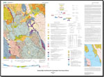
The Weaverville 15' quadrangle spans parts of five generally north-northwest-trending accreted terranes. From east to west, these are the Eastern Klamath, Central Metamorphic, North Fork, Eastern Hayfork, and Western Hayfork terranes. The Eastern Klamath terrane was thrust westward over the Central Metamorphic terrane during early Paleozoic (Devonian?) time and, in Early Cretaceous time (approx. 136 Ma), was intruded along its length by the massive Shasta Bally batholith. Remnants of overlap assemblages of the Early Cretaceous (Hauterivian) Great Valley sequence and the Tertiary Weaverville Formation cover nearly 10 percent of the quadrangle.
The base of the Eastern Klamath terrane in the Weaverville quadrangle is a peridotite-gabbro complex that probably is correlative to the Trinity ophiolite (Ordovician), which is widely exposed farther north beyond the quadrangle. In the northeast part of the Weaverville quadrangle, the peridotite-gabbro complex is overlain by the Devonian Copley Greenstone and the Mississippian Bragdon Formation. Where these formations were intruded by the Shasta Bally batholith, they formed an aureole of gneissic and other metamorphic rocks around the batholith. Westward thrusting of the Eastern Klamath terrane over an adjacent body of mafic volcanic and overlying quartzose sedimentary rocks during Devonian time formed the Salmon Hornblende Schist and the Abrams Mica Schist of the Central Metamorphic terrane. Substantial beds of limestone in the quartzose sedimentary unit, generally found near the underlying volcanic rock, are too metamorphosed for fossils to have survived. Rb-Sr analysis of the Abrams Mica Schist indicates a metamorphic age of approx. 380 Ma. West of Weavervillle, the Oregon Mountain outlier of the Eastern Klamath terrane consists mainly of Bragdon Formation(?) and is largely separated from the underlying Central Metamorphic terrane by serpentinized peridotite that may be a remnant of the Trinity ophiolite.
The North Fork terrane is faulted against the west edge of the Central Metamorphic terrane, and its northerly trend is disrupted by major left-lateral offsets along generally west-northwest-trending faults. The serpentinized peridotite-gabbro complex that forms the western base of the terrane is the Permian North Fork ophiolite, which to the east is overlain by broken formation of mafic-volcanic rocks, red chert, siliceous tuff, argillite, minor limestone, and clastic sedimentary rocks. The chert and siliceous tuff contain radiolarians of Permian and Mesozoic ages, and some are as young as Early Jurassic (Pliensbachian). Similar Pliensbachian radiolarians are found in Franciscan rocks of the Coast Ranges.
The Eastern Hayfork terrane is broken formation and melange of mainly chert, sandstone, argillite, and various exotic blocks. The cherts yield radiolarians of Permian and Triassic ages but none of clearly Jurassic age. Limestone bodies of the Eastern Hayfork terrane contain Permian microfaunas of Tethyan affinity.
The Western Hayfork terrane, exposed only in a small area in the southwestern part of the quadrangle, consists dominantly of mafic tuff and dark slaty argillite. Sparse paleontologic data indicate a Mesozoic age for the strata. The terrane includes small bodies of diorite that are related to the nearby Wildwood pluton of Middle Jurassic age and probably are related genetically to the stratified rocks. The terrane is interpreted to be the accreted remnants of a Middle Jurassic volcanic arc.
Shortly after intrusion by Shasta Bally batholith (approx. 136 Ma), much of the southern half of the Weaverville quadrangle was overlapped by Lower Cretaceous, dominantly Hauterivian, marine strata of the Great Valley sequence, and to a lesser extent later during Oligocene and (or) Miocene time by fluvial and lacustrine deposits of the Weaverville Formation.
This map of the Weaverville Quadrangle is a digital rendition of U.S. Geological Survey Miscellaneous Field


