
Bedrock geologic map of the Montpelier and Barre West quadrangles, Washington and Orange Counties, Vermont
Scientific Investigations Map
3111
Prepared in cooperation with the Vermont Geological Survey
Links
- More information: USGS Index Page (html)
- NGMDB Index Page: National Geologic Map Database Index Page
- Download citation as: RIS | Dublin Core
Abstract
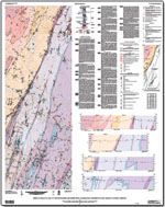
The bedrock geology of the Montpelier and Barre West quadrangles consists of Silurian and Devonian metasedimentary rocks of the Connecticut Valley-Gaspe synclinorium (CVGS) and metasedimentary, metavolcanic, and metaintrusive rocks of the Cambrian and Ordovician Moretown and Cram Hill Formations. Devonian granite dikes occur throughout the two quadrangles but are more abundant in the Silurian and Devonian rocks. The pre-Silurian rocks are separated from the rocks of the CVGS by the informally named 'Richardson Memorial Contact,' historically interpreted as either an unconformity or a fault.
The results of this report represent mapping by G.J. Walsh, Jonathan Kim, and M.H. Gale from 2002 to 2005. S.M. King assisted Kim and Gale from 2002 to 2003. A.M. Satkoski (Indiana University) assisted Walsh, and L.R. Pascale (University of Vermont) and C.M. Orsi (Middlebury College) assisted Kim and Gale as summer interns in 2003. This study was designed to map the bedrock geology in the area. This map supersedes a preliminary map of the Montpelier quadrangle (Kim, Gale, and others, 2003). A companion study in the Barre West quadrangle (Walsh and Satkoski, 2005) determined the levels of naturally occurring radioactivity in the bedrock from surface measurements at outcrops during the course of 1:24,000-scale geologic mapping to identify which rock types were potential sources of radionuclides. Results of that study indicate that the carbonaceous phyllites in the CVGS have the highest levels of natural radioactivity.
Suggested Citation
Walsh, G.J., Kim, J., Gale, M.H., and King, S.M., 2010, Bedrock geologic map of the Montpelier and Barre West quadrangles, Washington and Orange Counties, Vermont: U.S. Geological Survey Scientific Investigations Map 3111, Pamphlet: ii, 36 p.; 1 Plate: 40.05 inches x 50.67 inches, https://doi.org/10.3133/sim3111.
ISSN: 2329-132X (online)
Study Area
| Publication type | Report |
|---|---|
| Publication Subtype | USGS Numbered Series |
| Title | Bedrock geologic map of the Montpelier and Barre West quadrangles, Washington and Orange Counties, Vermont |
| Series title | Scientific Investigations Map |
| Series number | 3111 |
| DOI | 10.3133/sim3111 |
| Year Published | 2010 |
| Language | English |
| Publisher | U.S. Geological Survey |
| Contributing office(s) | U.S. Geological Survey |
| Description | Pamphlet: ii, 36 p.; 1 Plate: 40.05 inches x 50.67 inches |
| Country | United States |
| State | Vermont |
| Other Geospatial | Montpelier and Barre West quadrangles |
| Scale | 24000 |