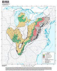
Much of the oil and gas in the Illinois, Michigan, and Appalachian basins of eastern North America is thought to be derived from Devonian shale that is within these basins (for example, Milici and others, 2003; Swezey, 2002, 2008, 2009; Swezey and others, 2005, 2007). As the Devonian strata were buried by younger sediments, the Devonian shale was subjected to great temperature and pressure, and in some areas the shale crossed a thermal maturity threshold and began to generate oil. With increasing burial (increasing temperature and pressure), some of this oil-generating shale crossed another thermal maturity threshold and began to generate natural gas. Knowledge of the thermal maturity of the Devonian shale is therefore useful for predicting the occurrence and the spatial distribution of oil and gas within these three basins. This publication presents a thermal maturity map of Devonian shale in the Illinois, Michigan, and Appalachian basins. The map shows outlines of the three basins (dashed black lines) and an outline of Devonian shale (solid black lines). The basin outlines are compiled from Thomas and others (1989) and Swezey (2008, 2009). The outline of Devonian shale is a compilation from Freeman (1978), Thomas and others (1989), de Witt and others (1993), Dart (1995), Nicholson and others (2004), Dicken and others (2005a,b), and Stoeser and others (2005).


