| Scientific Investigations Map 2859 |
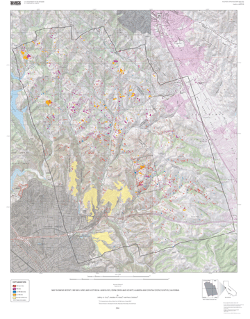
Map showing recent (1997-98 El Niño) and historical landslides, Crow Creek and vicinity, Alameda and Contra Costa Counties, California |
By Jeffrey A. Coe,1 Jonathan W. Godt,1 and Pierre Tachker2 |
1 U.S. Geological Survey, Denver Federal Center, MS 966, Denver, CO 80225 |
 |
| Version 1.0 |
| Published 2004 |
| The online edition of this publication consists of a digital database, metadata, and PDF files for the map sheet and accompanying pamphlet. A high-quality on-demand printed edition of this publication is for sale by Information Services, U.S. Geological Survey (1-888-ASK-USGS). |
| The text of this report is presented here in Portable Document Format. The latest version of Adobe Acrobat Reader® or similar software is required to view it. If you wish to download the latest version of Acrobat Reader® free of charge, click here. |
| Map for printing and viewing | |
| Pamphlet to accompany Map for printing and viewing (This version of the report is accessible as defined in Section 508.) |
SIM 2859 metadata files |
| Slides that occurred in 1998 (winter season of 1997-98) | |
Slides that occurred before 1998 |
|
| Debris flows that occurred in 1998 (winter season of 1997-98) | |
| Debris flows that occurred before 1998 |
| ZIPPED archive of ArcInfo export, metadata, and readme files | |
| TARRED and GZIPPED archive of ArcInfo export, metadata, and readme files |
| AccessibilityFOIAPrivacyPolicies and Notices | |
| |
|